
Ribnitz-Damgarten district
| Basic data (as of 1994) | |
|---|---|
| Existing period: | 1952-1994 |
| District : | Rostock |
| Administrative headquarters : | Ribnitz-Damgarten |
| Area : | 942 km² |
| Residents: | 66,400 (1985) |
| Population density: | 70 inhabitants per km² |
| License plate : | AF, AG (1974–1990)
RDG (1991-1994) |
| Circle structure: | 41 municipalities, including 4 cities |
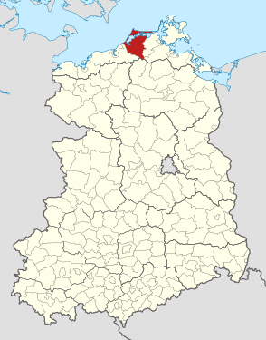
| Location of the district in the GDR | |
  |
|


The Ribnitz-Damgarten district was a district in the Rostock district in the GDR . From May 17, 1990, it continued as the Ribnitz-Damgarten district . Today his area belongs to the district of Vorpommern-Rügen in Mecklenburg-Western Pomerania . The seat of the district administration was in Ribnitz-Damgarten .
geography
location
The Ribnitz-Damgarten district with an outer coast of the Baltic Sea of approx. 60 kilometers in length encompassed the areas on the lower reaches of the Recknitz and Barthe rivers , the Fischland-Darß-Zingst peninsula chain and the Bodden waters between the peninsulas and the mainland, which are mostly flat or only slightly hilly terrain existed (highest point: 55 m above sea level in the south-west of the district).
Size and population
The district had an area of 942 km². That was 13.3% of the area of the Rostock district.
In 1985 there were around 66,400 inhabitants in the district. That was 7.4% of the district's population. Its population density was 70 inhabitants per km².
Neighboring areas
The Ribnitz-Damgarten district in the center of the Rostock district bordered the Rostock-Land district in the south-west, the Teterow district in the south, the Grimmen district in the southeast and the Stralsund district in the east .
history
The district consisting of Western Pomerania and Mecklenburg areas was created on July 25, 1952 from parts of the old districts of Rostock to the west and Franzburg-Barth (referred to as the district of Stralsund since 1946) to the east of the Recknitz , and after the dissolution of the states belonged to the newly formed district of Rostock . The district came to the newly founded state of Mecklenburg-Western Pomerania on October 3, 1990 within the accession area to the Federal Republic of Germany . On June 12, 1994, the district (referred to as the district since May 17, 1990) was dissolved and since then, together with the districts of Stralsund and Grimmen, which were also dissolved, until the district reform in 2011, the district of North Western Pomerania was formed .
Economy and Infrastructure
In the Ribnitz-Damgarten district, tourism dominated, especially in the summer season on the beaches of the Baltic Sea and the Bodden waters. The agricultural products of the "hinterland" were largely processed in the towns of the district, the catches of the fishing cooperatives in Barth and Ribnitz-Damgarten. The fiberboard factory in the district town of Ribnitz-Damgarten was the largest industrial company in the district . In the area of the district was also the socialist "model village" Trinwillershagen with its LPG "Red Banner".
The main traffic axis in the district was trunk road 105 ( Rostock - Stralsund ) and the parallel railway line. The roads connecting the seaside resorts, including the Meiningen Bridge, were of great importance for tourism . The Velgast-Barth and Velgast-Tribsees branch lines were of minor or seasonal importance.
cities and communes
On October 3, 1990, the Ribnitz-Damgarten district had 41 municipalities, including four cities:
- Ahrenshagen
- Ahrenshoop
- Allerstorf
- Bad Sülze , city
- Bartelshagen I b. Ribnitz-D.
- Bartelshagen II b. Barth
- Barth , city
- Böhlendorf
- Born a. Darß
- Breesen
- Brünkendorf
- Carlsruhe
- Daskow
- Dettmannsdorf
- Dierhagen
- Divitz
- Dudendorf
- Eixen
- Fuhlendorf
- Gresenhorst
- Kavelsdorf
- Kenz
- Cooling wheel
- Küstrow
- Langsdorf
- Löbnitz
- Ludershagen
- Marlow , town
- Prerow
- Pruchten
- Ravenhorst
- Ribnitz-Damgarten , city
- room
- Schlemmin
- Schuleberg
- Semlow
- Spoldershagen
- Trinwillershagen
- Wieck a. Darß
- Wustrow
- Zingst
License Plate
Motor vehicles (with the exception of motorcycles) and trailers were assigned three-letter distinguishing signs starting with the letter pairs AF and AG from around 1974 to the end of 1990 . The last number plate series used for motorcycles was AX 50-01 to AX 99-99 .
At the beginning of 1991 the district received the distinctive sign RDG . It was issued until June 11, 1994. It has been available in the Vorpommern-Rügen district since March 15, 2013 .


Individual evidence
- ↑ a b Federal Statistical Office (ed.): Municipalities 1994 and their changes since 01.01.1948 in the new federal states . Metzler-Poeschel, Stuttgart 1995, ISBN 3-8246-0321-7 .
- ↑ Law on the self-administration of municipalities and districts in the GDR (municipal constitution) of May 17, 1990
- ↑ Andreas Herzfeld: The history of the German license plate . 4th edition. German Flag Society V., Berlin 2010, ISBN 978-3-935131-11-7 , pp. 301 .
- ↑ Andreas Herzfeld: The history of the German license plate . 4th edition. German Flag Society V., Berlin 2010, ISBN 978-3-935131-11-7 , pp. 547 .