Long Island, Massachusetts
| long Island | ||
|---|---|---|
| Aerial view of the island | ||
| Waters | Quincy Bay , Boston Harbor , Atlantic Ocean | |
| Geographical location | 42 ° 19 '13 " N , 70 ° 57' 56" W | |
|
|
||
| length | 2.82 km | |
| surface | 90 ha | |
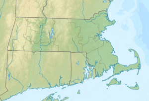
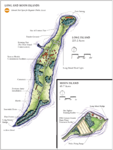
| Outline map of Long Island and Moon Island | ||
Long Island is an island in Boston Harbor . It is 7.33 mi (11.8 km ) from downtown Boston in the state of Massachusetts in the United States . It is administered by the City of Boston and is part of the Boston Harbor Islands National Recreation Area .
geography
geology
The island consists of three drumlins that reach heights of up to 95 ft (29 m ). The northeast end is known as Long Island Head , the southwest as West Head and a small area in the southeast as Bass Point . On the west side of the island there is marshland with drinking water . There are extensive mudflats around the island .
Flora and fauna
A great abundance of cultivated and natural plants grow on Long Island. The oldest trees, including shade trees and the remains of a garden with apple trees , are on the Long Island Campus , and there are many ornamental and perennial plants .
Long Island Head was free of trees until Fort Strong was closed , but is now increasingly populated by Rhus and poplars . There is an extensive grove of pine trees on the east side of the island , which was most likely planted by the Civilian Conservation Corps in the 1930s . The marshland in the southwest provides habitat for a number of different plants. A community garden and the nursery of the Friends of the Boston Harbor Islands Revegetation Project also contribute to the island's botanical diversity .
The island's wildlife is still the subject of scientific research.
history
The island was probably used by the Indians long before European colonization . During the colonial days , ownership passed to the city of Boston , which in turn leased it to farmers. During the King Philip's War , Christian Indians were relocated from Deer Island to alleviate overpopulation and famine. At the time of the American Revolution , the patriots were building defenses on Long Island .
A first lighthouse was installed in 1794 , which was replaced by a new building in 1819. Later it had to be moved to make way for fortifications. Even during the Civil War , the island was used for military purposes and equipped with extensive armament. In the late 19th century, the city of Boston established welfare facilities on the island, including an almshouse , a home for single mothers, a chronic disease hospital, and a nursing school .
The lighthouse Long Iceland Head Light was in the 1987 National Register of Historic Places entered.
Attractions
The towering water tower on the island's central drumlin provides water and water pressure for fire hydrants in the area. The tower, painted with a red and white checkerboard pattern, is used by the FAA as a navigation point when approaching Logan International Airport . Fort Strong's aqueducts remain to be explored.
The island is only partially accessible to the public. At the tip of the Squantum Peninsula in Quincy is a guardhouse and access gate to the 3,050 ft (929.6 m ) long, two-lane steel bridge that connects Long Island with Moon Island . There is a 1.2 mi (1.9 km ) long paved road on the island that extends from the dam to the hospital grounds and about 2 mi (3.2 km) total other roads.
The gun batteries at the northern end of the island harbor various hazards, including open sacking sites, eroded steps, and destroyed ladders and handrails. Vacant and crumbling buildings on Fort Strong's grounds also pose security risks. The viaduct has no sidewalk .
building
The following buildings are located on the island:
- Missile silo for Nike missiles (empty)
- Boston Environmental Protection Agency air quality monitoring station
- farm
- Greenhouses
- Laundry building
- Workshop
- Fire station
- Laboratory and morgue (vacant)
- Incinerator (empty)
- power plant
- Administration building
- Wastewater treatment plant
- Long Island Head Light
Fortifications
- Fort Strong
- Gun battery Ward
- Hitchcock gun battery
- Gun battery Drum
- Bassinger gun battery
- Smyth gun battery
- Gun battery Taylor
- Stevens gun battery
Other structures
- Viaduct (not open to the public)
- Pier (not open to the public)
- Civil War Memorial and Cemetery
- Hospital cemetery
- Water tower
- Unmarked cemetery
- Massachusetts Water Resources Authority valve stem
- Bank reinforcement made of granite blocks
literature
- Anthony Mitchell Sammarco: Boston's Harbor Islands (= Images of America ). Arcadia, Charleston, SC 1998, ISBN 978-0-7524-0900-9 .
Individual evidence
- ↑ a b c d e Island Facts: Long Island. National Park Service , accessed June 7, 2013 .


