Lovčica-Trubín
| Lovčica-Trubín | ||
|---|---|---|
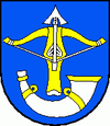
| coat of arms | map | |

|
|
|
| Basic data | ||
| State : | Slovakia | |
| Kraj : | Banskobystrický kraj | |
| Okres : | Žiar nad Hronom | |
| Region : | Pohrony | |
| Area : | 34.58 km² | |
| Residents : | 1,590 (Dec. 31, 2019) | |
| Population density : | 46 inhabitants per km² | |
| Height : | 344 m nm | |
| Postal code : | 966 23 | |
| Telephone code : | 0 45 | |
| Geographic location : | 48 ° 37 ' N , 18 ° 48' E | |
| License plate : | ZH | |
| Kód obce : | 517038 | |
| structure | ||
| Community type : | local community | |
| Administration (as of November 2018) | ||
| Mayor : | Štefan Horvát | |
| Address: | Obecný úrad Lovčica-Trubín 116 96623 Lovčica-Trubín |
|
| Website: | www.lovcica-trubin.sk | |
| Statistics information on statistics.sk | ||
Lovčica-Trubín is a municipality in central Slovakia, northwest of the town of Žiar nad Hronom .
geography
The municipality is located in the north-western parts of the Heiligenkreuz Basin ( Žiarská kotlina ) in the valley of the Trubín brook . A so-called Sauerbrunnen rises in the hallways of the village .
history
The community was created on July 9, 1971 through the union of the places Lovčica (German Kleinlotza , Hungarian Kislócsa ) and Trubín (German Trubein , Hungarian Garamkürtos ). Lovčica is in the east and Trubín in the west of the twin town .
Attractions
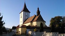
The originally Gothic church of Maria Madalena from 1487 and the chapel of the Most Holy Trinity from 1723 are worth seeing in the Trubín district. In Lovčica there is a chapel from the 18th century.
traffic
In June 1947 the Sv. Kríž nad Hronom ( Holy Cross on the Garn ) - Lovčica - Chapel - Handlová ( Krickerhau ) - Prievidza ( Priwitz ) and back.
Personalities
- Karol Bielek (1857–1936) - educator and publicist
- Jozef Kačka (1865–1938) - publicist
Web links
- Website (German)

