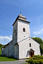
Janova Lehota
| Janova Lehota | ||
|---|---|---|
| coat of arms | map | |

|
|
|
| Basic data | ||
| State : | Slovakia | |
| Kraj : | Banskobystrický kraj | |
| Okres : | Žiar nad Hronom | |
| Region : | Pohrony | |
| Area : | 17.67 km² | |
| Residents : | 969 (Dec. 31, 2019) | |
| Population density : | 55 inhabitants per km² | |
| Height : | 425 m nm | |
| Postal code : | 966 24 | |
| Telephone code : | 0 45 | |
| Geographic location : | 48 ° 39 ' N , 18 ° 47' E | |
| License plate : | ZH | |
| Kód obce : | 516872 | |
| structure | ||
| Community type : | local community | |
| Administration (as of November 2018) | ||
| Mayor : | Božena Kováčová | |
| Address: | Obecný úrad Janova Lehota 96624 Janova Lehota |
|
| Website: | www.janovalehota.sk | |
| Statistics information on statistics.sk | ||
Janova Lehota (until 1927 "Janová Lehôta" in Slovak; German Drexlerhau , Hungarian Jánosgyarmat - until 1888 Janólehota ) is a municipality in central Slovakia.
It is located northwest of the town of Žiar nad Hronom in the foothills of the Bird Mountains ( Vtáčnik ).
The village was first mentioned in 1487 as a German settlement with the name Drexlerhau . It belonged to the so-called Hauerland .
At the last census in 2001, 93.76% of the population said they were Slovaks . There were also 2.35% Germans , 1.29% Ukrainians , 1.06% Czechs , 0.59% Roma and 0.12% Poles .
The majority of the population (80.47%) is Roman Catholic, there is also a Protestant (3.41%) and a Greek Orthodox (1.06%) minority. 11.29% of the population stated to be non-denominational.

