Prochot
| Prochot | ||
|---|---|---|
| coat of arms | map | |

|
|
|
| Basic data | ||
| State : | Slovakia | |
| Kraj : | Banskobystrický kraj | |
| Okres : | Žiar nad Hronom | |
| Region : | Pohrony | |
| Area : | 18.508 km² | |
| Residents : | 562 (Dec. 31, 2019) | |
| Population density : | 30 inhabitants per km² | |
| Height : | 497 m nm | |
| Postal code : | 966 04 (Post Office Horná Ždaňa ) | |
| Telephone code : | 0 45 | |
| Geographic location : | 48 ° 37 ' N , 18 ° 42' E | |
| License plate : | ZH | |
| Kód obce : | 517194 | |
| structure | ||
| Community type : | local community | |
| Administration (as of November 2018) | ||
| Mayor : | Martina Rozenbergová | |
| Address: | Obecný úrad Prochot č. 39 966 04 Horná Ždaňa |
|
| Website: | www.prochot.eu | |
| Statistics information on statistics.sk | ||
Prochot (until 1927 Slovak "Prochot" or "Prohod"; German Prochetzhau or Prochotzhau , Hungarian Kelo - to 1892 Prohot ) is a municipality in the middle of Slovakia with 562 inhabitants (December 31, 2019), which for Okres Žiar nad Hronom , part of the Banskobystrický kraj .
geography
The municipality is located on the eastern slope of the Vogelgebirge (Slovak Vtáčnik ) in the valley of the Prochotský potok in the catchment area of the Hron . The center of the village lies at an altitude of 497 m nm and is 19 kilometers from Žiar nad Hronom .
Neighboring municipalities are Handlová (district Nová Lehota) in the north, Lovčica-Trubín in the north-east, Prestavlky in the east, Horná Ždaňa in the south, Ostrý Grúň in the south-west, Kľak in the west and Podhradie in the north-west.
history
Bronze finds from the Late Bronze Age were found in today's municipality.
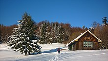
Prochot was first mentioned in writing in 1414 as Prehotha and belonged to the territory of the Šášov Castle . The originally German settlement can be recognized today in surnames and field names (e.g. Gronštolne in the picture above). In 1534 there were four porta . In 1601 there were 36 houses in the village, in 1715 the village had a mill and 27 taxpayers, including nine craftsmen. In 1828 there were 107 houses and 718 residents who were employed as lumberjacks, shepherds and farmers.
Until 1918, the place in Bars County belonged to the Kingdom of Hungary and then came to Czechoslovakia or now Slovakia. In 1945, shortly before the end of the Second World War, Prochot was ambushed and set on fire three times (January 4, January 21 and March 18) by Nazi German units after the partisan activity during the SNP was brisk.
population
According to the 2011 census, 598 inhabitants lived in Prochot, including 590 Slovaks and two Magyars and two Czechs . Four residents did not give any information about their ethnicity .
553 residents committed themselves to the Roman Catholic Church and one resident each to the Evangelical Church AB and the Orthodox Church. 36 inhabitants were without a denomination and the denomination was not determined for seven residents.
Buildings and monuments
- Roman Catholic St. Matthew's Church, rebuilt in classicist style from 1792, 1829 and 1850
Individual evidence
- ↑ Results of the 2011 census (Slovak)
- ↑ Prochot - Kostol sv. Matúša evanjelistu , pamiatkynaslovensku.sk, accessed on February 8, 2018
Web links
- Entry on e-obce.sk (Slovak)

