
Mello (Lombardy)
| Mello | ||
|---|---|---|

|
|
|
| Country | Italy | |
| region | Lombardy | |
| province | Sondrio (SO) | |
| Local name | Garbage | |
| Coordinates | 46 ° 9 ' N , 9 ° 33' E | |
| height | 681 m slm | |
| surface | 11 km² | |
| Residents | 940 (Dec. 31, 2019) | |
| Population density | 85 inhabitants / km² | |
| Post Code | 23010 | |
| prefix | 0342 | |
| ISTAT number | 014041 | |
| Popular name | Mellati | |
| Patron saint | Fedelis from Como ( October 28th ) | |
| Website | Mello | |

.svg)
Mello is a northern Italian municipality ( comune ) with 940 inhabitants (as of December 31, 2019) in the province of Sondrio in Lombardy .
geography
The municipality is located about 25 kilometers west of Sondrio in the Val di Mello of the same name . The neighboring municipalities are Civo , Novate Mezzola and Traona .
Attractions
- Parish church of San Fedele, in the interior three paintings and frescoes by Carlo Innocenzo Carloni from Rovio and squares by Giuseppe Coduri called il Vignoli (1763).
Picture gallery

Chiesa Parrocchiale di San Fedele, church tower

Chiesa Parrocchiale di San Fedele, front, nave

Street in Mello

Street in Mello
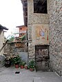
House in Mello with mural
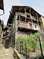
Building in Mello


literature
- Anna Ferrari-Bravo, Paola Colombini: Guida d'Italia. Lombardia (esclusa Milano). Milano 1987, p. 361.
- Lombardia - Touring club italiano, Touring Editore (1999), ISBN 88-365-1325-5 , Mello Online
- Mello on tuttitalia.it/lombardia
Web links
Individual evidence
- ↑ Statistiche demografiche ISTAT. Monthly population statistics of the Istituto Nazionale di Statistica , as of December 31 of 2019.

Albaredo per San Marco | Albosaggia | Andalo Valtellino | Aprica | Ardenno | Bema | Berbenno di Valtellina | Bianzone | Bormio | Buglio in Monte | Caiolo | Campodolcino | Caspoggio | Castello dell'Acqua | Castione Andevenno | Cedrasco | Cercino | Chiavenna | Chiesa in Valmalenco | Chiuro | Cino | Civo | Colorina | Cosio Valtellino | Dazio | Delebio | Dubino | Faedo Valtellino | Forcola | Fusine | Gerola Alta | Gordona | Grosio | Grosotto | Lanzada | Livigno | Lovero | Madesimo | Mantello | Mazzo di Valtellina | Mello | Mese | Montagna in Valtellina | Morbegno | Novate Mezzola | Pedesina | Piantedo | Piateda | Piuro | Poggiridenti | Ponte in Valtellina | Postalesio | Prata Camportaccio | Rasura | Rogolo | Samolaco | San Giacomo Filippo | Sernio | Sondalo | Sondrio | Spriana | Talamona | Tartano | Teglio | Tirano | Torre di Santa Maria | Tovo di Sant'Agata | Traona | Tresivio | Val Masino | Valdidentro | Valdisotto | Valfurva | Verceia | Vervio | Villa di Chiavenna | Villa di Tirano