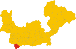
Gerola Alta
| Gerola Alta | ||
|---|---|---|

|
|
|
| Country | Italy | |
| region | Lombardy | |
| province | Sondrio (SO) | |
| Local name | Gerola | |
| Coordinates | 46 ° 4 ' N , 9 ° 33' E | |
| height | 1050 m slm | |
| surface | 38.3 km² | |
| Residents | 157 (Dec. 31, 2019) | |
| Population density | 4 inhabitants / km² | |
| Post Code | 23010 | |
| prefix | 0342 | |
| ISTAT number | 014031 | |
| Popular name | Gerolesi | |
| Patron saint | Bartholomew ( August 24 ) | |
| Website | Gerola Alta | |
Gerola Alta is a municipality ( comune ) in the Italian province ( Lombardy ) with 157 inhabitants (as of December 31, 2019) in Valtellina .
geography
The municipality is located about 27.5 kilometers west-southwest of Sondrio on the Parco delle Orobie Valtellinesi , belongs to the Comunità Montana Valtellina Di Morbegno and borders directly on the provinces of Bergamo and Lecco . The neighboring communities are Averara (BG), Bema , Cusio (BG), Introbio (LC), Ornica (BG), Pedesina , Premana (LC), Santa Brigida (BG) and Valtorta (BG).
Attractions
In the Pescegallo district there is a winter sports resort with two ski lifts for downhill skiing, but the area is best known for ski mountaineering.
literature
- Anna Ferrari-Bravo, Paola Colombini: Guida d'Italia. Lombardia (esclusa Milano). Milano 1987, p. 366.
- Lombardia - Touring club italiano, Touring Editore (1999), ISBN 88-365-1325-5 , Gerola Alta Online
- Gerola Alta on tuttitalia.it/lombardia
Web links
Commons : Gerola Alta - collection of images, videos and audio files
Individual evidence
- ↑ Statistiche demografiche ISTAT. Monthly population statistics of the Istituto Nazionale di Statistica , as of December 31 of 2019.


