Myrne (Melitopol)
| Myrn | ||
| Мирне | ||

|
|
|
| Basic data | ||
|---|---|---|
| Oblast : | Zaporizhia Oblast | |
| Rajon : | Melitopol district | |
| Height : | 214 m | |
| Area : | 1.02 km² | |
| Residents : | 3,086 (2014) | |
| Population density : | 3,025 inhabitants per km² | |
| Postcodes : | 72350 | |
| Area code : | +380 6192 | |
| Geographic location : | 46 ° 57 ' N , 35 ° 26' E | |
| KOATUU : | 2323055500 | |
| Administrative structure : | 1 urban-type settlement | |
| Address: | вул. Радянська 14 72350 смт. Мирне |
|
| Statistical information | ||
|
|
||
Myrne ( Ukrainian Мирне ; Russian Мирное Mirnoje ) is an urban-type settlement in the Ukrainian Oblast of Zaporizhia with around 3,000 inhabitants (2014).
Myrne is the only village in the settlement council of the same name and received urban-type settlement status in 1987.
The village is located on the bank of the Molochna in Melitopol district, 15 km north of the Melitopol district center . To the north, Myrne borders the village of Terpinnja . The M 18 trunk road runs west of the village .
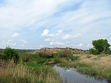
To the east of Mryne is the Kamjana Mohyla , a sandstone hill with petroglyphs that date back to the Mesolithic , and an attached museum .
Individual evidence
- ↑ Demographics of Ukrainian cities on pop-stat.mashke.org , accessed on March 18, 2015


