
Northland (New Zealand)
| Northland region | |
| Geographical location | |
  |
|
| Photo from Northland Region | |
 The lighthouse at Cape Reinga in the Far North District |
|
| Local authority | |
| Country | New Zealand |
| island | North island |
| Local authority | region |
| Council | Northland Region Council |
| Headquarters of the administration | Whangarei |
| founding | 1989 |
| Website | www.nrc.govt.nz |
| geography | |
| Region ISO | NZ-NTL |
| Coordinates | 35 ° 44 ′ S , 174 ° 19 ′ E |
| Highest elevation | 781 m |
| surface | 12 498 km 2 |
| Residents | 151 692 (2013) |
| Population density | 12.14 inhabitants per km 2 |
| Statistical data | |
| Public revenue | NZ $ 33.2 million (2015) |
| Public expenditure | NZ $ 29.4 million (2015) |
| Number of households | 74 337 (2013) |
| Ø income | NZ $ 23,400 (2013) |
| Māori population | 29.6% (2013) |
The Northland Region is the northernmost of New Zealand's seventeen administrative regions . The regional council, called Northland Regional Council , is based in Whangarei .
geography
Geographical location

The Northland Region is located in the northernmost part of the North Island of New Zealand and covers about 80% of the Northland Peninsula with 12,498 km² of pure land area . With 151,692 inhabitants counted in 2013, the region has a population density of 12.1 inhabitants per km². The Regional Council gives its land area with 13,286 km². This does, however, include the bodies of water that are not included in the general statistics of the Department of Internal Affairs . The highest point is the Te Raupua with 781 m , the largest lake is the Lake Ōmāpere and the longest river is the Wairoa River . The coast of the region extends for around 3200 km.
Northland is surrounded to the west by the Tasman Sea and to the north and east by the Pacific Ocean . In the south the region borders on the area of the Auckland Council .
With a few exceptions, the west coast of the region is straight, while the east coast is rugged and has numerous bays and natural harbors. The largest natural harbors include Hokianga Harbor and Kaipara Harbor on the west coast and Parengarenga Harbor , Rangaunu Harbor and Whāngārei Harbor on the east coast. The northernmost points on the coast of the region and thus at the same time the northernmost points of the main islands of New Zealand are Cape Reinga and North Cape .
Is by far the largest city in the region Whangarei with around 45,100 inhabitants Whangarei (as of 2013). It is also the seat of the administration of the region and the Whangarei District s . Other notable places are Dargaville in the Kaipara District and Kaikohe in the Far North District .
Northland has an overall rural character and the landscape can mostly be described as hilly. More than half of the area is used for agriculture or forestry. Only remnants of the originally extensive Kauri forests still exist, such as the Waipoua Forest , as the forests in the region were cut down mainly in the 19th century.
climate
The region's climate is described as subtropical, with mild winters and warm, humid summers. The summer temperatures are on average 15 to 25 ° C depending on the time of day and location, in winter between 8 and 15 ° C accordingly. Temperatures above 30 ° C are possible. Depending on the local conditions, the annual rainfall is between 1000 and 2000 mm and the duration of sunshine around 2000 hours over the year, on the east coast even around 2100 hours.
Since the region rarely experiences frost in the winter months, New Zealanders also call it "The Winterless North" . Occasionally, foothills of tropical cyclones reach Northland.
history
Northland is considered to be the “cradle” of their settlement history for both the Māori and the white European settlers . According to Māori legends , the Polynesian navigator Kupe landed in Hokianga about 1000 years ago and many tribes consider him their direct ancestor. Some of the oldest traces of human habitation in New Zealand have been found in Northland . The British navigator and explorer James Cook landed on the coast of Northland in 1769 . The first white settlers arrived mostly in Northland in the late 18th century and the first permanent European settlements arose here. In the village of Kerikeri is the Kemp House, the oldest preserved building in New Zealand. The Treaty of Waitangi , which was signed at Waitangi on February 6, 1840 and is considered to be the founding charter of modern New Zealand, has special historical significance for the whole of New Zealand.
population
Population development
In 2013, 44,928 of the 151,692 inhabitants of the region were of Māori origin (29.6%). This means that 7.5% of the country's Māori population lived in the Northland region . The median income for the population in 2013 was NZ $ 23,400 compared to NZ $ 28,500 national average.
Origin and languages
When asked about ethnic group membership in the 2013 census, 75.7% said they were European, 32.4% said they had Māori roots, 3.2% came from the islands of the Pacific region and 2.8% were from from Asia (multiple answers were possible). 15.6% of the population said they were born overseas and 9.1% of the population spoke Māori , of the Māori 26.2%.
politics
administration
The Northland Region has a board of directors called the Regional Council , which is led by a chairman . The council has nine elected councilors representing seven constituencies , Te Hiku , Hokianga-Kaihohe , Kaipara , Costal North , Costal Central , Costal South and Whāngārei Urban . The council members, who choose the chairman from their ranks, are re-elected every three years.
Furthermore, the region is divided into three districts:
While the regional administration is responsible for the inland and coastal waters, for the ports, for land, air, erosion, disaster control, transport planning and regional development, the administrations of the districts are responsible for all other concerns of the citizens and for all matters which are in a municipality must be regulated.
economy
The main industries in Northland are agriculture and forestry , especially cattle breeding, fishing and the cultivation of citrus fruits . After most of the native forests were cleared in the late 19th century, not only agricultural land but also forests were created that are used to produce wood. Because of this, wood-processing factories came into being, especially for paper production.
The third pillar of the regional economy is tourism . The Bay of Islands and the historically important town of Kerikeri play a particularly important role here .
New Zealand's only oil refinery is located near Whangarei . The crude oil comes partly from New Zealand's most important oil field in the Taranaki region and partly from the Middle East .
Infrastructure
traffic
The region is accessible by the New Zealand State Highway 1 , which runs from north to south and connects with Auckland , and the State Highways 10 , 11 , 12 , 14 and 1F , all of which connect parts of the country within the region.

Ripiro Beach on the west coast
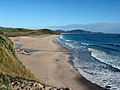
Ocean Beach on the east coast

Wairoa River , the longest river in the region

The Kemp House (right) is the oldest surviving building in the country
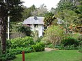
Pompallier House in Russel


Web links
- Homepage . Northland Regional Council,accessed June 8, 2016.
- Homepage . Northland Regional Council,accessed June 8, 2016(Tourism website for the region).
Individual evidence
- ↑ a b 2013 Census QuickStats about a place : Northland Region - Population and dwellings . Statistics New Zealand , accessed June 8, 2016 .
- ↑ a b Northland Regional Council . In: Local Councils . Department of Internal Affairs , accessed June 8, 2016 .
- ↑ a b About our region . Northland Regional Council , accessed June 8, 2016 .
- ↑ Topo250 maps . Land Information New Zealand , accessed June 7, 2016 .
- ↑ Local Governance Statement . (PDF 393 kB) Whangarei District Council , November 2013, accessed on June 7, 2016 .
- ^ PR Chappell : The Climate and Weather of Northland . In: NIWA Science and Technologies Series . 3. Edition. Number 59 . National Institute of Water and Atmospheric Research , 2013, ISSN 1173-0382 , p. 17, 24, 28 (English, online PDF 2.4 MB [accessed June 8, 2016]).
- ↑ 2013 Census QuickStats about a place : Northland Region - Cultural diversity . Statistics New Zealand , accessed June 8, 2016 .
- ^ Your Councilors . Northland Regional Council , accessed June 8, 2016 .
- ↑ Glossary . In: Local Councils . Department of Internal Affairs , accessed June 8, 2016 .
North Island : Northland | Auckland * | Waikato | Bay of Plenty | Gisborne * | Hawke's Bay | Taranaki | Manawatu-Wanganui | Wellington
South Island : Tasman * | Marlborough * | Nelson * | West Coast | Canterbury | Otago | Southland
Other islands: Chatham Islands *