
Payrac
| Payrac | ||
|---|---|---|
.svg)
|
|
|
| region | Occitania | |
| Department | Lot | |
| Arrondissement | Gourdon | |
| Canton | Souillac | |
| Community association | Causses et Vallée de la Dordogne | |
| Coordinates | 44 ° 48 ′ N , 1 ° 28 ′ E | |
| height | 125-364 m | |
| surface | 19.5 km 2 | |
| Residents | 620 (January 1, 2017) | |
| Population density | 32 inhabitants / km 2 | |
| Post Code | 46350 | |
| INSEE code | 46215 | |

|
||

Payrac is a French commune with 620 inhabitants (as of January 1, 2017) in the Lot department in the Occitanie region . It belongs to the Arrondissement of Gourdon and Canton Souillac . The inhabitants are called "Payracois" or "Payracoises".
geography
The municipality is located in the Bouriane countryside on the D820 departmental road between Cahors (49 km - southwest) and Souillac (15 km - north) and the D673 departmental road.
Payrac is surrounded by the neighboring communities Loupiac in the north, Calès in the northeast, Reilhaguet in the southeast, Le Vigan in the south, Anglars-Nozac in the southwest, Rouffilhac in the west and Lamothe-Fénelon in the northwest.
Population development
| year | 1962 | 1968 | 1975 | 1982 | 1990 | 1999 | 2007 | 2012 |
| Residents | 523 | 512 | 456 | 448 | 492 | 564 | 672 | 639 |
Attractions
- The castle, a 16th century castle with a tower that was inhabited from 1856 to 1957 by the Sisters of Saint Vincent de Paul (Sœurs de Saint Vincent de Paul) .
- Church of St. Peter (Église Saint-Pierre)
- Town Hall (L'hôtel de ville) , built in 1911
- Town houses from the 18th and 19th centuries
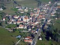
Payrac, aerial photo
winter 2009
Tower of the castle
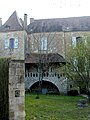
Balcony of the castle

St. Peter's Church

Church window

Interior view of St. Peter

Town hall from 1911

Houses near the castle


