
Montcléra
| Montcléra | ||
|---|---|---|
|
||
| region | Occitania | |
| Department | Lot | |
| Arrondissement | Gourdon | |
| Canton | Puy-l'Évêque | |
| Community association | Communauté de communes Cazals-Salviac | |
| Coordinates | 44 ° 37 ′ N , 1 ° 13 ′ E | |
| height | 154-311 m | |
| surface | 20.91 km 2 | |
| Residents | 271 (January 1, 2017) | |
| Population density | 13 inhabitants / km 2 | |
| Post Code | 46250 | |
| INSEE code | 46200 | |

Montcléra is a French commune with 271 inhabitants (as of January 1, 2017) in the Lot department in the Occitanie region . It belongs to the canton of Puy-l'Évêque and the Arrondissement of Gourdon .
Neighboring municipalities are Marminiac in the northwest, Cazals in the north, Gindou in the northeast, Les Arques in the southeast, Goujounac in the south, Frayssinet-le-Gélat in the southwest and Saint-Caprais in the west.
Population development
| year | 1962 | 1968 | 1975 | 1982 | 1990 | 1999 | 2008 | 2015 |
|---|---|---|---|---|---|---|---|---|
| Residents | 380 | 360 | 335 | 291 | 317 | 291 | 275 | 281 |
Attractions
- Montcléra Castle
- Saint-Caprais church

Montcléra Castle

Saint-Caprais church
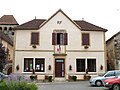
Mairie from Montcléra


Web links
Commons : Montcléra - collection of images, videos and audio files