
Thégra
| Thégra | ||
|---|---|---|
|
||
| region | Occitania | |
| Department | Lot | |
| Arrondissement | Gourdon | |
| Canton | Gramat | |
| Community association | Communauté de communes Causses et Vallée de la Dordogne | |
| Coordinates | 44 ° 49 ′ N , 1 ° 45 ′ E | |
| height | 319-426 m | |
| surface | 12.82 km 2 | |
| Residents | 472 (January 1, 2017) | |
| Population density | 37 inhabitants / km 2 | |
| Post Code | 46500 | |
| INSEE code | 46317 | |

Thégra is a French commune with 472 inhabitants (as of January 1, 2017) in the Lot department in the Occitania region . It belongs to the canton of Gramat and the Arrondissement of Gourdon .
Neighboring municipalities are Miers in the northwest, Padirac in the north, Loubressac in the northeast, Mayrinhac-Lentour in the east, Lavergne in the southeast, Gramat in the south, Rignac in the southwest and Alvignac in the west.
Population development
| year | 1962 | 1968 | 1975 | 1982 | 1990 | 1999 | 2008 | 2015 |
|---|---|---|---|---|---|---|---|---|
| Residents | 414 | 387 | 387 | 408 | 432 | 416 | 495 | 473 |
Attractions
- Thégra Castle, monument historique since 1960
- Cemetery, Monument historique since 1923
- Romanesque church of Saint-Barthélemy, monument historique since 1923

Castle and church next door in the municipality of Thégra

Cemetery cross
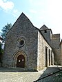
Saint Barthélemy Church

Mairie Thégra


Web links
Commons : Thégra - collection of images, videos and audio files