
Padirac
| Padirac | ||
|---|---|---|
|
||
| region | Occitania | |
| Department | Lot | |
| Arrondissement | Gourdon | |
| Canton | Gramat | |
| Community association | Causses et Vallée de la Dordogne | |
| Coordinates | 44 ° 51 ′ N , 1 ° 45 ′ E | |
| height | 318-426 m | |
| surface | 8.86 km 2 | |
| Residents | 158 (January 1, 2017) | |
| Population density | 18 inhabitants / km 2 | |
| Post Code | 46500 | |
| INSEE code | 46213 | |
 Mairie Padirac |
||

Padirac is a French municipality with 158 inhabitants (at January 1, 2017) in the department of Lot in the Région Okzitanien (2015 Midi-Pyrenees ). It belongs to the Arrondissement of Gourdon and to the community association Causses et Vallée de la Dordogne, founded in 2016 . The inhabitants are called Padiracois .
geography
The municipality is located in the Causse de Gramat , part of the Haut Quercy landscape in the Causses du Quercy Regional Nature Park . The calcareous soil does not allow any surface running water. The landscape is characterized by wide dry grass areas and smaller forest areas. In the higher northeast of the municipality there are several dolmens and five shaft caves, of which the Gouffre de Padirac (Gorge of Padirac) is known nationwide. Padirac is surrounded by the neighboring communities of Gintrac in the north, Loubressac in the east, Thégra in the south and Miers in the west. The largest districts of the municipality of Padirac are Le Ratier, Latreille, Bord, Rigal, Lacoste, Bagou, Panot, Bascoul, Calcas, Le Salvage, Mathieu, Teilié and Sayssac .
history
The place name Padirac is based on the Latin anthroponym Palerius . The ending -ac is a typical Gallic suffix. The municipality of Padirac was founded in 1828 by separating out parts of the municipality of Miers.
Population development
| year | 1962 | 1968 | 1975 | 1982 | 1990 | 1999 | 2006 | 2016 |
| Residents | 224 | 177 | 162 | 148 | 160 | 168 | 185 | 159 |
| Sources: Annuaire-mairie and INSEE | ||||||||
Attractions
- Gouffre de Padirac cave
- Saint-Julien church
- Château de Padirac
- several hall crosses
- Barns
- Insectopia , an insect museum
- 13 stone tables , compiled and researched by Armand Viré in 1930; the biggest of them:
- Dolmen d'Andrieu appelé, also called Dolmen du Champ de Monsieur
- Dolmen d'Escurettes
- Dolmen de Bougoulat
- Dolmen des Calcas appelé, also called Dolmen de Penot
- Dolmen des Claouzelles
- Dolmens of the Pendus: (2 dolmens)
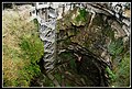
Entry shaft to the cave

Entrance to the cave

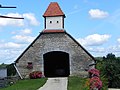
Saint-Julien church

Château de Padirac
old barn

Hotel and restaurant "La Charmille"


.jpg)

.jpg)

Economy and Infrastructure
In the municipality of Padirac there is a bakery, a butcher and a hairdresser as well as small craft shops. In addition to tourism, agriculture also plays an important role in the municipality. 15 farms are located in Padirac (cereal and vegetable growing, dairy farming, horse, goat, sheep, cattle and poultry breeding).
The D673 road from Rocamadour to Saint-Céré runs through the municipality of Padirac . In Souillac , 18 kilometers to the north-west, there is a connection to the ( Autoroute A20 ). The Rocamadour-Padirac station, eight kilometers to the west, is on the railway line from Brive-la-Gaillarde via Capdenac to Toulouse ( Ligne de Brive-la-Gaillarde à Toulouse-Matabiau via Capdenac ).
supporting documents
- ↑ Gaston Bazalgues, Les noms des communes du Parc , Les cahiers scientifiques du Parc naturel régional des Causses du Quercy, Volume 1, 2014, p. 115 (PDF file, French)
- ↑ Padirac on annuaire-mairie.fr
- ↑ Padirac on insee.fr
- ↑ Farmers in Padirac on annuaire-mairie.fr (French)
Web links
- Website of the municipality (French)