Marminiac
| Marminiac | ||
|---|---|---|
|
|
||
| region | Occitania | |
| Department | Lot | |
| Arrondissement | Gourdon | |
| Canton | Gourdon | |
| Community association | Cazals-Salviac | |
| Coordinates | 44 ° 40 ′ N , 1 ° 12 ′ E | |
| height | 177–343 m | |
| surface | 22.88 km 2 | |
| Residents | 361 (January 1, 2017) | |
| Population density | 16 inhabitants / km 2 | |
| Post Code | 46250 | |
| INSEE code | 46184 | |
| Website | http://www.marminiac.fr/ | |
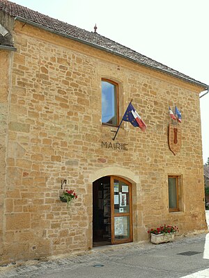
 City Hall (Mairie) of Marminiac |
||
Marminiac is a southern French municipality with 361 inhabitants (as of January 1, 2017) in the Lot department in the Occitanie region (before 2016: Midi-Pyrénées ). The municipality belongs to the Arrondissement of Gourdon (until 2017: Arrondissement Cahors ) and the canton of Gourdon (until 2015: Canton of Cazals ).
location
Marminiac is located about 31 kilometers northwest of Cahors in the Quercy region - or more precisely the Bouriane - in the heart of the Périgord noir . Marminiac is surrounded by the neighboring communities of Campagnac-lès-Quercy in the north, Salviac in the east, Cazals in the south and south-east, Montcléra in the south, Saint-Caprais in the south-west, Villefranche-du-Périgord in the west and south-west and Besse in the west.
Population development
| year | 1962 | 1968 | 1975 | 1982 | 1990 | 1999 | 2006 | 2013 |
| Residents | 530 | 460 | 385 | 368 | 307 | 318 | 358 | 371 |
| Source: Cassini and INSEE | ||||||||
Attractions
- 13th century Saint Vincent church
- So-called English tower from the 13th century, partially destroyed in the Hundred Years War, later rebuilt
- Roquecave Castle from the 17th century
- Bonafous castle from the 15th century


