Port Louis
| Port Louis | ||
|---|---|---|

|
||
| Basic data | ||
| Region: | Port Louis | |
| Coordinates: | 20 ° 10 ′ S , 57 ° 30 ′ E | |
| Height: | 5 ü. d. M. | |
| Founding year: | 1638/1735 | |
| Surface: | 46.7 km² | |
| Residents: | 148,147 (2017) | |
| Time zone: | UTC +4 | |
| Telephone code: | N / A | |
| Website: | http://www.mccpl.mu/ | |
| Geographical location in Mauritius | ||
|
|
||
Port Louis ( French Port-Louis ) is the capital of the island state of Mauritius in the Indian Ocean, east of Africa .
With around 150,000 inhabitants, it is the largest city in the country and represents the economic and cultural center of the island. There is a ferry connection to Le Port , the port city of the Mascarene island of Réunion, about 180 km away . Air traffic to and from Mauritius is handled via Sir Seewoosagur Ramgoolam International Airport at Plaine-Magnien , near Mahébourg , 30 km southeast of Port Louis. The city's industrial companies manufacture sugar, wood and paper products, among other things.
In a ranking of cities according to their quality of life, Port Louis ranked 83rd out of 231 cities worldwide in 2018. The city achieved the best placement in all of Africa.
geography
location
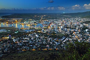
Port Louis is on the northwest coast of the island. Mountain ridges in the hinterland protect the city from the southeastern trade winds . Towards the sea there are smaller hills, which offer a good panoramic view of the generally quite lively city.
climate
|
Average monthly temperatures and rainfall for Port Louis
Source: World Meteorological Organization The climatological data are based on the monthly averages from 1971 to 2000;
|
||||||||||||||||||||||||||||||||||||||||||||||||||||||||||||||||||||||||||||||||||||||||||||||||||||||||||||||||||||||||||||||||||||||||||||||||||||||||||||||||||||||||||||||||||||||||||||||||||||||||||||||||||||||||||||||||||||||||||||||||
history
When the Republic of the Seven United Netherlands took Mauritius in 1638, Port Louis (under the Dutch name of Noord-Wester Haven at the time , later taken over by the French under the name Port Nord-Ouest , which was still in use in the 18th century ) was one of them both port places. The French East India Company established a settlement here in 1731 after the failure of its colonization efforts on Madagascar made a new supply station in the western Indian Ocean necessary. Under Governor Mahé de La Bourdonnais , the Port Louis company developed into its strategic center in this maritime area from 1735 onwards.
When the French colonial policy in South India also failed in 1754 ( Second Carnatic War ), Port Louis advanced to become the most important port for French shipping in the Indian Ocean. In the course of the intensification of the plantation economy in the interior of Mauritius, the company had tens of thousands of slaves from South Asia and East Africa brought to the island via the port. In the mid-1770s, about 75 percent of the city's population was enslaved.
In 1767, Governor Pierre Poivre withdrew the company's trade monopoly and declared Port Louis a free port for French citizens . As a result, trade increased substantially because French merchants used the city as a hub for goods from Asia. At the same time, France expanded the port into a naval base. During the American War of Independence and the Napoleonic Wars , French corsairs used the port as a base for pirate trips against British merchant ships. To capitalize on the booty, France opened Port Louis to foreign ships.
In view of the military and economic importance of the port, in order not to risk a conflict of secession with the powerful merchants and planters, after the French Revolution the government decided not to enforce the abolition of slavery in Mauritius, which had been decided by parliament. Around 1800 the authorities divided the city into six districts and segregated the population according to status, class, region of origin and religion.
In 1810 Great Britain conquered Mauritius in order to eliminate the corsairs operating from Port Louis as a threat to British shipping. With the Paris Peace of 1814, the British incorporated the island permanently into their colonial empire for reasons of security strategy.
Under British rule, the city lost its status as a free port and initially suffered a slump in shipping traffic. In 1816 a fire destroyed much of Port Louis. In 1818 a cholera epidemic decimated the urban population considerably. The authorities used the decline in population to restructure the urban space. In the absence of paved drinking water canals, drains for sewage and waste disposal, the epidemic spread of infectious diseases remained a major problem for the city throughout the 19th century. In the course of the development of a sugar cane monoculture in the interior of Mauritius, Port Louis advanced to one of the most important sugar ports of the 19th century from 1826 and shipping increased again. After the abolition of slavery in 1835, the British administration had hundreds of thousands of contract workers from South Asia and East Africa brought to the island via the port.
In the second half of the 19th century, the port experienced a decline in importance because its infrastructure was not designed for the now increasingly used steamships and because trade in the Indian Ocean shifted north after the opening of the Suez Canal in 1869. At the same time, however, British and French shipping companies now integrated Port Louis into passenger traffic. From 1866 to 1868 the worst cholera epidemic in the history of Port Louis occurred. The generally high death rate in the city prompted the colonial administration at the end of the 19th century to evacuate the troops stationed in Port Louis inland. After the Spanish flu also raged exceptionally devastatingly in the city in 1919 , the British colonial administration took measures to improve the sanitary infrastructure.
In 1968 Mauritius became independent and Port Louis was declared the capital.
Population development
The following overview shows the population by area since the 1983 census.
| year | Residents |
|---|---|
| 1983 (census) | 139,300 |
| 2000 (census) | 154.257 |
| 2011 (census) | 149.226 |
| 2017 (estimate) | 148.147 |
traffic
There are several city bus routes in Port Louis.
The 26 km long Metro Express line connects Port Louis with four other cities in Mauritius: Curepipe , Vacoas, Rose Hill and Quatre Bornes . It serves 19 stops with a total travel time of 40 minutes. The first sales are expected in 2021. Most of the route will be aligned to the standard gauge of the Mauritius government railroad Midland Line , which closed in 1964. It is planned to extend the route by a further 11 km in the future.
The Road Development Authority is responsible for the entire project management. The estimated project cost of US $ 600 million is partially covered by a US $ 300 million grant from the Indian government.
The Spanish CAF is the supplier of the rail vehicles. This project includes the delivery of 18 Urbos units , the signaling technology , the automatic vehicle localization, the right of way signaling technology at level crossings and the equipment for the tram depot and a driving simulator.
Attractions
- Citadel (Citadel, Fort Adelaïde) - with a good view of the city
- Aapravasi Ghat - UNESCO World Heritage Site, remains of a warehouse for contract workers of Indian origin from the 19th century
- Blue Penny Museum - one of four unstamped Blue Mauritius stamps is on display here
- Mauritius Postal Museum , a listed former main post office, now the Postal Museum
- Champs de Mars - oldest horse racing track in the southern hemisphere
- Le Caudan Waterfront - shopping street by the harbor, also shown on the back of the 50 rupee banknote
- small Chinatown with archway
- Garden of the East India Company
- Jewish cemetery Saint Martin (124 graves, see Atlantic Drift )
- Mauritius Institute (Natural History Museum)
- Minakshi Temple - South Indian Hindu temple from 1854 of the Tamil population group
- Place d'Armes - a palm-planted, busy square
- State bank building - a modern " skyscraper "
- Theater, well-preserved historical building from 1822 with 600 seats, used for amateur theater performances and for weddings
Town twinning
Port Louis has partnered with the following cities:
|
sons and daughters of the town
- Charles Baissac (1831-1892), British Romanist and Creole artist
- Léon Carvalho (1825–1897), French singer and opera director
- Amanda Courtaux (1856–1941), French music teacher and composer
- Charles Favez (1885–1960), Swiss classical philologist
- Henri Le Sidaner (1862–1939), French painter
- Elodie Li Yuk Lo (* 1982), beach volleyball player
- Tom von Prince (1866–1914), German colonial officer
- Francis Thomé (1850–1909), French composer
literature
- Breejan Burrun: Port Louis, Mauritius. Christian le Comte, Pereybere 2009, ISBN 978-9-994-93000-5 .
- Felix Schürmann: The gray undercurrent. Whalers and coastal societies on the deep beaches of Africa (1770–1920) . Campus Verlag, Frankfurt am Main / New York City 2017, ISBN 978-3-593-50675-3 .
- Auguste Toussaint: Port Louis: A Tropical City. Allen & Unwin, London 1973, ISBN 978-0-049-69001-1 .
Web links
Individual evidence
- ↑ Mauritius: Districts, Cities & Towns - Population Statistics, Maps, Charts, Weather and Web Information. Retrieved April 5, 2018 .
- ↑ Mercer's 2018 Quality of Living Rankings. Retrieved August 18, 2018 .
- ↑ To the general history section : Felix Schürmann: The gray undercurrent. Whalers and coastal societies on the deep beaches of Africa (1770–1920) . Campus Verlag, Frankfurt am Main / New York City 2017, pp. 346–370.
- ↑ Mauritius: Regions, Cities & Urban Settlements - Population Statistics, Maps, Charts, Weather and Web Information. Retrieved January 7, 2019 .
- ↑ Mauritius: Work on the construction of the light rail begins. Retrieved January 12, 2020 .
- ↑ CAF. Accessed January 12, 2020 (German).
- ↑ Marion Meisig: Tamil Hinduism in Mauritius. The Mīnāk · ī Temple in Port Louis. ( Memento from June 7, 2007 in the Internet Archive ) In: Mitteilungen für Anthropologie und Religionsgeschichte, Vol. 14, Ugarit-Verlag, Münster 2001, pp. 251-274
- ^ Website Port Louis - international links , accessed on January 22, 2019


