
Prague 16
| Prague 16 Radotín |
|||
|---|---|---|---|
|
|||
| Basic data | |||
| State : |
|
||
| Region : | Hlavní město Praha | ||
| Municipality : | Praha | ||
| Area : | 931 ha | ||
| Geographic location : | 49 ° 59 ' N , 14 ° 22' E | ||
| Residents : | 8,320 (December 31, 2015) | ||
| Postal code : | 153 00 | ||
| structure | |||
| Status: | District ( městská část ) | ||
| administration | |||
| Mayor : | Karel Hanzlík (as of 2016) | ||
| Address: | Václava Balého 23 153 00 Praha 5 - Radotín |
||
| Website : | www.praha16.eu | ||


Prague 16 or Radotín is an administrative district and a district of the Czech capital Prague . The administrative district Prague 16 is located in the southwest of the city and includes the Prague 16 district and the cadastral municipalities of Lipence , Lochkov , Velká Chuchle and Zbraslav . The Prague 16 district is identical to the Radotín cadastral municipality.
history
Radotín was first mentioned in writing as a ford on the Berounka in a document of the Bohemian King Vladislav II , which was written between 1156 and 1168.
In 1967 Radotín was granted town charter, in 1974 it was annexed to Prague and in 1990 it became an independent district.
traffic
The Praha-Radotín station is on the Praha – Plzeň (171) line on which the S7 express train runs. Shortly before the confluence with the Vltava, there is a cargo port on the Berounka . Along the Berounka there is a cycle path that branches off to Zbraslav.

Praha-Radotín railway station
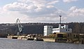
Radotín harbor
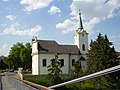
Parish church Peter and Paul on the Berounka

The Radotín Valley in 1914


Prague 1 | Prague 2 | Prague 3 | Prague 4 (Prague 4, Kunratice ) | Prague 5 (Prague 5, Slivenec ) | Prague 6 (Prague 6, Lysolaje , Nebušice , Přední Kopanina , Suchdol ) | Prague 7 (Prague 7, Troja ) | Prague 8 (Prague 8, Březiněves , Ďáblice , Dolní Chabry ) | Prague 9 | Prague 10 | Prague 11 (Prague 11, Křeslice , Šeberov , Újezd ) | Prague 12 (Prague 12, Libuš ) | Prague 13 (Prague 13, Řeporyje ) | Prague 14 (Prague 14, Dolní Počernice ) | Prague 15 (Prague 15, Dolní Měcholupy , Dubeč , Petrovice , Štěrboholy ) | Prague 16 ( Radotín , Lipence , Lochkov , Velká Chuchle , Zbraslav ) | Prague 17 ( Řepy , Zličín ) | Prague 18 ( Letňany , Čakovice ) | Prague 19 ( Kbely , Satalice , Vinoř ) | Prague 20 (Horní Počernice) | Prague 21 ( Újezd nad Lesy , Běchovice , Klánovice , Koloděje ) | Prague 22 (Prague 22, Benice , Kolovraty , Královice , Nedvězí )