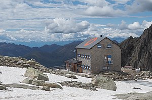
Rifugio Cima d'Asta - Ottone Brentari
| Rifugio Cima d'Asta - Ottone Brentari SAT refuge category D |
||
|---|---|---|
| location | Cima d'Asta ; Trentino , Italy ; Valley location: Pieve Tesino | |
| Mountain range | Lagorai , Fiemme Valley Alps | |
| Geographical location: | 46 ° 10 '12.7 " N , 11 ° 36' 15.8" E | |
| Altitude | 2473 m slm | |
|
|
||
| builder | SAT | |
| owner | SAT section Pieve Tesino | |
| Built | 1908 | |
| Construction type | Refuge | |
| Usual opening times | from June 20th to September 20th | |
| accommodation | 60 beds, 0 camps | |
| Winter room | 4 beds | |
| Web link | www.rifugio-cimadasta.it | |
The Rifugio Cima d'Asta - Ottone Brentari or just Rifugio Cima d'Asta or Rifugio Brentari (German Cima d'Asta hut ) is a refuge of the Pieve Tesino section of the Trentino Alpine Association (SAT).
Location and surroundings
The Rifugio Cima d'Asta is located in the municipality of Pieve Tesino in the province of Trento at 2476 m slm. It is located at the end of the Val Sorgazza valley directly below the south face of the Cima d'Asta on a small moraine hill just a few meters from Lake Cima d'Asta away.
The Sentiero Italia and Alta Via del Granito pass the hut .
history
Shortly after the turn of the century there were the first suggestions to build a refuge below the Cima d'Asta. In 1907, construction began on the hut, which was inaugurated a year later on August 24, 1908. At that time it still had a compact, cube-like shape, like many other huts in Trentino, and for a long time it was the only rifugio in the largest mountain group in Trentino, the Lagorai.
It was badly damaged in the First World War, but was able to reopen in 1922. The hut was named after the journalist and geographer Ottone Brentari from Trentino who died a year earlier.
During the Second World War, the refuge was broken into and looted several times. In August 1952, it reopened for the second time in 30 years. It retained its original shape from 1908 and only had 18 beds. In 1982 the SAT decided to increase the rifugio and with it the number of sleeping places. Work began in 1984 and on September 1, 1985, the three times larger hut was inaugurated.
Accesses
- From Malga Sorgazza, 1450 m ⊙ on path 327 (3 hours)
- From Malga Sorgazza, 1450 m ⊙ via Campagnassa on path 386 (4 hours 30 minutes)
- From Caoria, 817 m ⊙ on path 338, 387 (5 hours 30 minutes)
- From Maléne, 1100 m ⊙ on path 338, 387 (5 hours)
Neighboring huts and crossings
- To Rifugio Malga Consèria, 1848 m ⊙ on path 327, 326 in 3 hours 30 minutes
- To Rifugio Malga Caldenave, 1792 m on paths 327, 326, 373, 360 in 6 hours
- To Pront (Val Cia), 1056 m ⊙ on path 364, 363 in 4 hours
- To Passo Brocon , 1616 m ⊙ on path 386, 387, 396 in 7 hours
- To Capanna Giuseppe Cavinato , 2840 m ⊙ on path 364 in 1 hour 15 minutes
Mountaineering
- Cima d'Asta, 2847 m ⊙ 1 hour 15 minutes
- Col del Vento, m 2634 ⊙ 2 hours
- Cima dei Diavoli, m 2806 ⊙ 2 hours 15 minutes
literature
- Achille Gadler, Mario Corradini: Rifugi e bivacchi nel Trentino. Panorama, Trento 2003, ISBN 978-88-87118-40-7 .
- Società degli Alpinisti Tridentini - Sezione del CAI - Commissione Sentieri: … per sentieri e luoghi. Sui monti del Trentino. 2 Lagorai, Cima d'Asta, Calisio, Monti di Cembra. Euroedit, Trento 2013, ISBN 978-88-86147-96-5 .
Web links
- Rifugio Cima d'Asta - O. Brentari , website of the Società degli Alpinisti Tridentini
References and comments
- ↑ This old construction can still be seen at the Rifugio Monzoni in the Valle dei Monzoni
- ↑ Brentari was the author of numerous area guides on Trentino and is one of the pioneers in this field.
- ^ Società degli Alpinisti Tridentini - Sezione del CAI - Commissione Sentieri: … per sentieri e luoghi. Sui monti del Trentino. 2 Lagorai, Cima d'Asta, Calisio, Monti di Cembra. P. 293 f
- ^ Achille Gadler, Mario Corradini: Rifugi e bivacchi nel Trentino. P. 314


