
Saga prefecture
|
Saga-ken 佐賀 県 |
|
|---|---|
  |
|
| Basic data | |
| Administrative headquarters : | saga |
| Region : | Kyushu |
| Main island : | Kyushu |
| Area : | 2,440.7 km² |
| Water content: | 1.7 % |
| Residents : | 814.211 (October 1, 2019) |
| Population density : | 334 inhabitants per km² |
| Counties : | 6th |
| Municipalities : | 20th |
| ISO 3166-2 : | JP-41 |
| Governor : | Yoshinori Yamaguchi |
| Website: | www.pref.saga.lg.jp |
| Symbols | |
| Prefecture flag : |
 |
| Prefecture tree : | Camphor tree |
| Prefecture flower : | Camphor tree blossom |
| Vogel prefecture : | magpie |
| Prefecture song : |
Saga-kenmin no uta ("Song of the Citizens of Saga") |
The Saga Prefecture ( Jap. 佐賀県 Saga-ken ) is a prefecture in Japan . It is located in the Kyūshū region on the island of the same name and originated in the eastern part of the historical Hizen Province . It has existed continuously since 1883, when it finally became independent from Nagasaki after several territorial rearrangements in the early Meiji period.
The seat of the prefecture administration is the city of the same name Saga .
geography
Saga Prefecture is located between Fukuoka Prefectures in the east and Nagasaki in the south and southwest. The border between Saga and Fukuoka runs along the ridge of the Sefuri Mountains ( 脊 振 山地 , Sefuri-sanchi ).
Administrative division
In the table below, the districts (郡) are shown in italics, with the small towns (町) below them (indented). The first three digits of the code (1st column) also show a relationship between the district and the small town. At the beginning of the table are the independent cities (市).
| code | Surname | Area (in km²) | population | Population density (inh / km²) |
||
|---|---|---|---|---|---|---|
| Rōmaji | Kanji | 01.10.2017 1 | 01.10.2018 2 | 01/10/2015 3 | ||
| 41201 | Saga- shi | 佐賀 市 | 431.84 | 234,342 | 236.372 | 547.36 |
| 41202 | Karatsu- shi | 唐 津市 | 487.59 | 119.208 | 122,785 | 251.82 |
| 41203 | Tosu- shi | 鳥 栖 市 | 71.72 | 74,137 | 72.902 | 1,016.48 |
| 41204 | Taku- shi | 多久 市 | 96.96 | 1,888 | 19,749 | 203.68 |
| 41205 | Imari- shi | 伊万 里 市 | 255.25 | 53,955 | 55,238 | 216.41 |
| 41206 | Takeo- shi | 武雄 市 | 195.40 | 48.261 | 49,062 | 251.08 |
| 41207 | Kashima- shi | 鹿島 市 | 112.12 | 28,561 | 29,684 | 264.75 |
| 41208 | Ogi- shi | 小 城市 | 95.81 | 43,717 | 44,259 | 461.95 |
| 41209 | Ureshino- shi | 嬉 野 市 | 126.41 | 26,349 | 27,336 | 216.25 |
| 41210 | Kanzaki- shi | 神 埼 市 | 125.13 | 31,306 | 31,842 | 254.47 |
| 41320 | Kanzaki gun | 神 埼 郡 | 43.99 | 16,338 | 16,411 | 373.06 |
| 41327 | Yoshinogari-chō | 吉野 ヶ 里 町 | 43.99 | 16,338 | 16,411 | 373.06 |
| 41340 | Miyaki-gun | 三 養 基 郡 | 86.86 | 51,964 | 52,062 | 599.38 |
| 41341 | Kiyama-cho | 基 山 町 | 22.15 | 17,371 | 17,501 | 790.11 |
| 41345 | Chimney-cho | 上 峰 町 | 12.80 | 9,364 | 9,283 | 725.23 |
| 41346 | Miyaki-cho | み や き 町 | 51.92 | 25,229 | 25,278 | 486.86 |
| 41380 | Higashimatsuura gun | 東 松浦 郡 | 35.92 | 5,518 | 5,902 | 164.31 |
| 41387 | Genkai-cho | 玄 海 町 | 35.92 | 5,518 | 5,902 | 164.31 |
| 41400 | Nishimatsuura gun | 西松 浦 郡 | 65.85 | 19,563 | 20,148 | 305.97 |
| 41401 | Arita- cho | 有 田 町 | 65.85 | 19,563 | 20,148 | 305.97 |
| 41420 | Kishima-gun | 杵 島 郡 | 135.54 | 38,718 | 40,301 | 297.34 |
| 41423 | Ōmachi-chō | 大 町 町 | 11.50 | 6,397 | 6,777 | 589.30 |
| 41424 | Kōhoku-machi | 江北 町 | 24.49 | 9,519 | 9,583 | 391.30 |
| 41425 | Shiroishi-cho | 白石 町 | 99.56 | 22.802 | 23,941 | 240.47 |
| 41440 | Fujitsu-gun | 藤 津 郡 | 74.30 | 8,293 | 8,779 | 118.16 |
| 41441 | Tara-cho | 太 良 町 | 74.30 | 8,293 | 8,779 | 118.16 |
| Saga prefecture | 佐賀 県 | 2,440.68 | 819.110 | 832.832 | 341.23 | |
swell
1 Area data from 2017
2 Estimated population 2018
3 Results of the 2015 census
Biggest places
| Census year | Residents | |||
|---|---|---|---|---|
| 2015 | 2010 | 2005 | 2000 | |
| saga | 236.372 | 237.506 | 206.967 | 167.955 |
| Karatsu | 122,785 | 126,926 | 128,564 | 78,945 |
| Tosu | 72.902 | 69,074 | 64,723 | 60,726 |
| Taku | 19,749 | 21,404 | 22,739 | 23,949 |
| Imari | 55,238 | 57.161 | 58,190 | 59,143 |
| Takeo | 49,062 | 50,699 | 33,697 | 34,603 |
| Kashima | 29,684 | 30,720 | 32,117 | 33,215 |
| Ogi | 44,259 | 45.133 | 45,852 | —— |
| Ureshino | 27,336 | 28,984 | —— | —— |
| Kanzaki | 31,842 | 32,899 | —— | —— |
The independent city of Ogi was founded in 2005,
the independent cities of Ureshino and Kanzaki were founded in 2006. .
Population development in the prefecture
| Census year |
Total population |
male population |
female population |
Gender ratio men to 1000 women |
Area in km 2 |
Population density per km 2 |
|---|---|---|---|---|---|---|
| 1920 | 673.895 | 329,962 | 343.933 | 959 | 2443.59 | 275.8 |
| 1925 | 684.831 | 336.223 | 348,608 | 965 | 2443.90 | 280.2 |
| 1930 | 691,565 | 337.996 | 353,569 | 956 | 2443.90 | 283.0 |
| 1935 | 686.117 | 332.764 | 353.353 | 942 | 2449.03 | 280.2 |
| 1940 | 701.517 | 343.047 | 358,470 | 957 | 2449.03 | 286.5 |
| 1945 | 830.431 | 379.361 | 451.070 | 841 | 2449.03 | 339.1 |
| 1950 | 945.082 | 455.824 | 489.258 | 932 | 2403.74 | 393.2 |
| 1955 | 973.749 | 470,437 | 503.312 | 935 | 2403.50 | 405.1 |
| 1960 | 942,874 | 448,797 | 494.077 | 908 | 2403.50 | 392.3 |
| 1965 | 871.885 | 410.937 | 460,948 | 892 | 2406.17 | 362.4 |
| 1970 | 838.468 | 393,631 | 444,837 | 885 | 2410.91 | 347.8 |
| 1975 | 837.674 | 394,661 | 443.013 | 891 | 2417.87 | 346.5 |
| 1980 | 865,574 | 410.912 | 454,662 | 904 | 2432.71 | 355.8 |
| 1985 | 880.013 | 417,308 | 462.705 | 902 | 2433.39 | 361.6 |
| 1990 | 877.851 | 414.673 | 463.178 | 895 | 2438.76 | 360.0 |
| 1995 | 884.316 | 418,666 | 465,650 | 899 | 2438.99 | 362.6 |
| 2000 | 876.654 | 414.377 | 462.277 | 896 | 2439.23 | 359.4 |
| 2005 | 866.369 | 408.230 | 458.139 | 891 | 2439.58 | 355.1 |
| 2010 | 849,788 | 400.136 | 449,652 | 890 | 2439.65 | 348.3 |
| 2015 | 832.832 | 393.073 | 439,759 | 894 | 2440.68 | 341.2 |
history
After the Meiji Restoration , the principalities (-han) Saga , Hasunoike , Ogi , Kashima , Karatsu , Izuhara were temporarily named prefectures (-ken) in 1871 , which were merged into the prefecture Imari ( 伊万 里 県 , Imari-ken ) in the same year were. This was renamed Saga in 1872, the former Izuhara (also Tsushima- Fuchū ; Tsushima Province ) was transferred to Nagasaki . Saga Prefecture was incorporated into Mizuma in 1876, which was dissolved in 1876 and divided between Fukuoka and Nagasaki. In 1883 Saga was separated from Nagasaki again.
politics
Yasushi Furukawa , then Saga’s third term governor, resigned in November 2014 for a change in national politics. In the January 2015 gubernatorial election , former central government official Yoshinori Yamaguchi was elected as his successor. In December 2018, he was re-elected against a communist challenger, and voter turnout fell by almost 20 points to a new record low of 35.3%. The 38-member parliament was re-elected in the uniform regional elections in April 2019 , the LDP remained by far the strongest force. The number of women in parliament doubled to two.
In the national parliament Saga since 2014 only by two directly elected members in Shugiin and an ever election in Sangiin represented. After the elections of 2016 and 2019, the Liberal Democrats Takamaro Fukuoka (2nd term of office, until 2022) and Yūhei Yamashita (2nd term of office, until 2025) sit in the Sangiin for the prefecture , while Saga elected the Minshintō independent Kazuhiro Haraguchi (8th ) to the Shūgiin in 2017 Term of office, constituency 1), who later joined the DVP , and Hiroshi Ōgushi ( Kibō no Tō , 5th term, constituency 2, later non-party to the KDP faction), who narrowly prevailed against ex-governor Furukawa.
Saga is one of the financially weaker prefectures in the country.
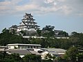
Karatsu Castle
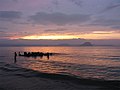
Beach in Hamatama
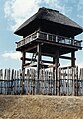
Reconstruction of the Yoshinogari site

Road signs in Saga prefecture


Web links
Individual evidence
- ↑ Kokudo Chiriin (GSI - Geospatial Information Authority of Japan), 平 成 29 年 全国 都 道 府 県 市区 町 村 別 面積 調 (Nationwide survey of all prefectures and municipalities 2017) , p. 89: 41 Saga-ken (Japanese), accessed on 16 December 2018
- ↑ 簡 単 検 索 ・ 詳細 検 索 ・ 検 索 サ ン プ ル , accessed December 16, 2018 (Japanese)
- ↑ e-stat (English), accessed on December 16, 2018
- ↑ e-Stat database , accessed on December 16, 2018 (English)
- ↑ "Sagāsha" (from Saga and Ākāsha ; pages of the prefecture administration for children): 佐賀 県 の あ ゆ み 江 戸 時代 ~ 明治 ・ 大 正
- ↑ Saga Prefectural Parliament : MPs (by constituency) , accessed on June 9, 2019.
- ↑ 佐賀 県 知事 選 は 現 職 山口 氏 が 再 選 投票 率 は 過去 最低 を 大 大 き く 下回 る . In: Mainichi Shimbun . December 16, 2018, accessed June 9, 2019 .
- ↑ 統一 地方 選 2019 佐賀 県 議 選 各 党 議席 . In: NHK Senkyo Web. April 7, 2019, Retrieved June 9, 2019 (Japanese).
Aichi | Akita | Aomori | Chiba | Ehime | Fukui | Fukuoka | Fukushima | Gifu | Gunma | Hiroshima | Hokkaidō | Hyōgo | Ibaraki | Ishikawa | Iwate | Kagawa | Kagoshima | Kanagawa | Kochi | Kumamoto | Kyoto | Mie | Miyagi | Miyazaki | Nagano | Nagasaki | Nara | Niigata | Ōita | Okayama | Okinawa | Osaka | Saga | Saitama | Shiga | Shimane | Shizuoka | Tochigi | Tokyo | Tokushima | Tottori | Toyama | Wakayama | Yamagata | Yamaguchi | Yamanashi
Coordinates: 33 ° 17 ' N , 130 ° 10' E