San Antonio de Cachi District
| San Antonio de Cachi District | |
|---|---|
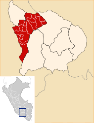
 The district of San Antonio de Cachi is located in the far west of the Andahuaylas province (marked in red) |
|
| Basic data | |
| Country | Peru |
| region | Apurímac |
| province | Andahuaylas |
| Seat | San Antonio de Cachi |
| surface | 179 km² |
| Residents | 3047 (2017) |
| density | 17 inhabitants per km² |
| founding | June 8, 1936 |
| ISO 3166-2 | PE-APU |
| politics | |
| Alcalde District | Samuel Mallma Salazar (2019-2022) |
Coordinates: 13 ° 46 ′ S , 73 ° 36 ′ W
The district of San Antonio de Cachi is located in the Andahuaylas province in the Apurímac region in central southern Peru . The district was founded on June 8, 1936. It has an area of 179 km². The 2017 census counted 3,047 inhabitants. In 1993 the population was 3577, in 2007 it was 3186. The district administration is located in the 3250 m high town of San Antonio de Cachi with 198 inhabitants (as of 2017). San Antonio de Cachi is located 26 km west-southwest of the provincial capital Andahuaylas .
Geographical location
The district of San Antonio de Cachi is located in the Andean highlands in the far west of the Andahuaylas province. The rivers Río Chicha (also Río Soras), Río Pampas and Río Huarcanay limit the district to the west and north.
The district of San Antonio de Cachi is bordered to the west by the districts of Chilcayoc , Chalcos and Belén (all three in the province of Sucre ), to the northwest by the districts of Carhuanca and Saurama (both in the province of Vilcas Huamán ), to the north by the district of Uranmarca ( Chincheros Province ), in the northeast to the Santa María de Chicmo district , in the east to the Huancaray district and to the south to the Chiara district .
Localities
In addition to the main town, the district has the following localities:
- Campanayoc
- Cachihuancaray
- Cachiyaurecc
- Ccapcca (215 inhabitants)
- Chullisana (369 inhabitants)
- Huantana (269 inhabitants)
- San Juan Bautista (391 inhabitants)
- San Juan de Kula (397 inhabitants)
Web links
- Peru: Region Apurímac (provinces and districts) at www.citypopulation.de
- INEI Perú