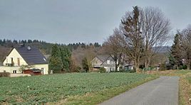
Schieten (Solingen)
|
Schießen
City of Solingen
Coordinates: 51 ° 13 ′ 0 ″ N , 7 ° 5 ′ 30 ″ E
|
||
|---|---|---|
| Height : | about 250 m | |
| Postal code : | 42653 | |
| Area code : | 0212 | |
|
Location of Schieten in Solingen |
||
|
Schießen
|
||
The location of Schieten in the Solingen district of Gräfrath goes back to an old place name.
location
Schieten is located northeast of the center of Gräfrath.
Neighboring locations are Steinbeck , Flockertsholz and Flockertsberg , Oben zum Holz and Haus Grünewald . In the municipal area of Wuppertal , the locations Roßkamp , Boltenheide and Schieten (Wuppertal) are in the immediate vicinity.
etymology
The origin of the name Schieten is not exactly known. A connection can probably be traced back to 'divide', 'divide' = border. In addition to the district boundary, a watershed can also be meant.
history
In the map series Topographia Ducatus Montani by Erich Philipp Ploennies from 1715, the place with the name Schieten is drawn (the one further north, in what is now the Wuppertal area, is labeled by Ploennies as a. Scheidt ). The topographical survey of the Rhineland from 1824 lists the place as a. Scheit and the Prussian premiere from 1844 as Schieten .
After the Mairien and later mayor's offices were founded at the beginning of the 19th century, Heide belonged to the Gräfrath mayor's office . In 1815/16 76 people lived in the village. In 1830 90 people lived in the village. In 1832 the place was still part of the Honschaft (Ketz-) Berg within the mayor's office of Gräfrath. The place, which was categorized as a Hofstadt according to the statistics and topography of the Düsseldorf administrative district , had ten residential buildings, a factory or mill and eight agricultural buildings at that time. At that time, 98 residents lived in the village, all of whom were evangelicals. The municipality and estate district statistics of the Rhine Province list the place in 1871 with 14 houses and 97 inhabitants. In the municipality lexicon for the province of Rhineland from 1888, eleven houses with 71 inhabitants are given for the place named Schiete at the time . In 1895 the district had 13 houses with 81 inhabitants, in 1905 twelve houses and 72 inhabitants are given.
The houses Schieten 7 and Schieten 8 are protected as an architectural monument.
Web links
Individual evidence
- ↑ a b Wolfgang Stock: Wuppertal street names . Thales Verlag, Essen-Werden 2002, ISBN 3-88908-481-8
- ^ Wilfried Heimes : The beginnings of the district Sonnborn in the Bergisches Land and their development, 1961
- ^ A b Friedrich von Restorff : Topographical-statistical description of the Royal Prussian Rhine Province , Nicolai, Berlin and Stettin 1830
- ↑ a b Johann Georg von Viebahn : Statistics and Topography of the Administrative District of Düsseldorf , 1836
- ↑ Royal Statistical Bureau Prussia (ed.): The communities and manor districts of the Prussian state and their population . The Rhine Province, No. XI . Berlin 1874.
- ↑ Königliches Statistisches Bureau (Prussia) (Ed.): Community encyclopedia for the Rhineland Province, based on the materials of the census of December 1, 1885 and other official sources, (Community encyclopedia for the Kingdom of Prussia, Volume XII), Berlin 1888.
- ↑ Königliches Statistisches Bureau (Prussia) (Ed.): Community encyclopedia for the Rhineland Province, based on the materials of the census of December 1, 1895 and other official sources, (Community encyclopedia for the Kingdom of Prussia, Volume XII), Berlin 1897.
- ↑ Königliches Statistisches Bureau (Prussia) (Ed.): Community encyclopedia for the Rhineland Province, based on the materials of the census of December 1, 1905 and other official sources, (Community encyclopedia for the Kingdom of Prussia, Volume XII), Berlin 1909.


