
Shanshang (Tainan)
| Shanshang | |||
.svg) Location of Shanshang in Tainan |
|||
| State : |
|
||
| Coordinates : | 23 ° 5 ' N , 120 ° 22' E | ||
| Area : | 27.8780 km² | ||
| Residents : | 7,300 (Feb 2019) | ||
| Population density : | 262 inhabitants per km² | ||
| Time zone : | UTC + 8 (Chungyuan time) | ||
| Telephone code : | (+886) (0) 6 | ||
| Postal code : | 743 | ||
| ISO 3166-2 : | TW-TNN | ||
| Community type : | Municipality of Tainan | ||
| Structure : | 7 districts ( 里 , Lǐ ) | ||
| Website : | |||
|
|||

Shanshang ( Chinese 山上 區 , Pinyin Shānshàng Qū , Pe̍h-ōe-jī San-siōng-khu ) is a district of the government -direct city of Tainan in the southwest of the Republic of China in Taiwan .
Location and description
The district is located a little south of the center of the urban area of Tainan and has an approximately crescent shape with an east-west extension of about 8.8 kilometers and a north-south extension of 7.1 kilometers. The neighboring districts are Danei in the north, Shanhua and Xinshi in the west, Xinhua and Zuozhen in the south, and Yujing in the east. With an area of almost 27.8 km², Shanshang is the sixth smallest of the 37 districts of Tainan.
Over a larger (western) section, the Zengwen River ( 曾文溪 , Zéngwén Xī ) forms the northern border of the district. About two thirds of the district is occupied by plains, the remaining third by mountainous areas. The altitude increases to the east. Geologically, the Shanshang area is essentially an alluvial plain .
history
Historically, the area was populated by indigenous Austronesian ethnic groups ( Pingpu ) from the Siraya tribe. The first settlements of Han Chinese immigrants were on a hill from which the plain could be seen. This gave rise to the name Shanziding ( 山 仔 頂 , Shān zǐ dǐng - "settlement on the mountain top"). During the Japanese colonial rule (1895–1945), the region was administratively reorganized on October 1, 1920 and became the village of Shanshang ( 山上 庄 ; Japanese Shanshang Shō , Chinese Shanshang Zhuāng ) in the Xinhua district ( 新化 郡 ; Japanese Xīnhuà Gun , Chinese Xīnhuà Jùn ) in the prefecture of Tainan ( Tainan Shū , 臺南 州 ) summarized. After the Republic of China took over the island of Taiwan in 1945, the Japanese administrative units were largely retained and only renamed. The village of Shanshang became the rural community ( 鄉 , Xiāng ) Shanshang in the newly established Tainan County . A border adjustment took place on July 1, 1946, when the two villages of Neitanding and Dashe were ceded to the neighboring community of Xinshi. For this purpose, the village of Pinghe was annexed to Shanshang by the neighboring community of Zuozhen and renamed 'Pingyang'.
On December 25, 2010, Tainan County was dissolved and fully incorporated into the city of Tainan. Shanshang thus received the status of a city district ( 區 , Qū ).
population
With a population of around 7,300, Shanshang was third from last among the 37 districts of Tainan in 2019. The population has been falling for years. Members of indigenous peoples only make up about 0.3% of the population.
| Outline of Shanshang |

|
Administrative division

Shanshang is divided into 7 districts ( 里 , Lǐ ).
1 Minghe ( 明 和 里 )
2 Nanzhou ( 南 洲 里 )
3 Shanshang ( 山上 里 )
4 Xinzhuang ( 新 莊里 )
5 Fengde ( 豐 德里 )
6 Pingyang ( 平陽 里 )
7 Yufeng ( 玉峯 里 )
traffic
National Road 3 runs in a north-south direction directly on the western edge of the district (in the neighboring districts of Shanhua and Xinshi) . Shanshang is traversed by County Road 178, which runs from northwest to southeast. The latter joins Provincial Road 20, which runs through a small section of Shanshang, in the far south.
Agriculture
Agriculture is the most important industry. In 2013, 1,462 hectares were farmed. The traditional crops in earlier times were (wet) rice, sweet potatoes and sugar cane . More recently, these have been replaced by commercially profitable products, in particular papaya (79 ha), pineapple (293 ha) or ornamental plants (eg. B. peace lily , philodendron , epipremnum , gold fruit palm , Polyscias guilfoylei , Croton and Dieffenbachia ).
Special features and tourist destinations
So far, tourism has not played a major role in Shanshang. One of the attractions is the orchid garden ( 蘭科 植物園 , Lán kē Zhíwùyuán , ) in Yufeng, which is considered to be the largest of its kind in Taiwan. The Taoist Tian Hou Temple ( 天 后宮 ) in the village of Shanshang is worth seeing due to its rich design. In the village of Shanshang, water treatment plants from the Japanese era can also be viewed, which are classified as “national historical monuments” ( 國 定 古蹟 , Guódìng gǔjī ). The systems were built in 1912–1922 for Tainan's water supply.
![]()
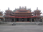
Tian Hou Temple

_01.jpg)
Web links
Individual evidence
- ↑ Natural environment. Old (?) Website of Shanshang, October 28, 2013, accessed on March 22, 2019 (English).
- ↑ a b Local history. Old (?) Website of Shanshang, October 28, 2013, accessed on March 22, 2019 (English).
- ↑ 原住民 戶數 及 人數 Households and Persons of Indigenous People. (xls) Taiwan Ministry of the Interior, accessed May 5, 2018 (Traditional Chinese, English).
- ^ Administrative district. Old (?) Website of Shanshang, October 28, 2013, accessed on March 23, 2019 (English).
- ^ Industries. Old (?) Website of Shanshang, October 28, 2013, accessed on March 23, 2019 (English).
- ↑ Famous Tourist. New (?) Shanshang District website, January 2, 2019, accessed March 23, 2019 .
- ^ Orchid Botanical Garden. Old (?) Shanshang District website, April 14, 2015, accessed March 23, 2019 .
- ↑ 山上 天 后宮 ("Shanshang Tian Hou Temple"). Temple website, accessed March 23, 2019 (Traditional Chinese).
- ↑ Historical Landmark - Tainan Shuidao. Old (?) Shanshang District website, April 14, 2015, accessed March 23, 2019 .
Core city: center-west | Eastern District | South District | Northern District | Anping | Annan
Outer city: Anding | Baihe | Trimmings | Danei | Dongshan | Guanmiao | Guantian | Guiren | Houbi | Jiali | Jiangjun | Liujia | Liuying | Longqi | Madou | Nanhua | Nanxi | Qigu | Rende | Shanhua | Shanshang | Xiaying | Xigang | Xinhua | Xinshi | Xinying | Xuejia | Yanshui | Yongkang | Yujing | Zuozhen