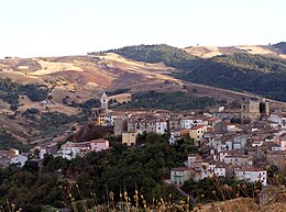
Tufara
| Tufara | ||
|---|---|---|

|
|
|
| Country | Italy | |
| region | Molise | |
| province | Campobasso (CB) | |
| Coordinates | 41 ° 29 ′ N , 14 ° 57 ′ E | |
| height | 420 m slm | |
| surface | 35.2 km² | |
| Residents | 832 (Dec. 31, 2019) | |
| Population density | 24 inhabitants / km² | |
| Post Code | 86010 | |
| prefix | 0874 | |
| ISTAT number | 070082 | |
| Popular name | Tufaroli | |
| Patron saint | John the Hermit (August 28) | |
| Website | Tufara | |
Tufara is an Italian commune ( comune ) with 832 inhabitants (as of December 31, 2019) in the province of Campobasso in Molise . The municipality is located about 25 kilometers east-southeast of Campobasso and borders directly on the provinces of Benevento ( Campania ) and Foggia ( Apulia ). The Fortore flows through Tufara .
Web links
Commons : Tufara - collection of images, videos and audio files
Individual evidence
- ↑ Statistiche demografiche ISTAT. Monthly population statistics of the Istituto Nazionale di Statistica , as of December 31 of 2019.


