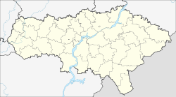
Turki (Saratov)
| Urban-type settlement
Turki
Турки
|
||||||||||||||||||||||||||||||||
|
||||||||||||||||||||||||||||||||
|
||||||||||||||||||||||||||||||||
Turki ( Russian Турки́ ) is an urban-type settlement in the Saratov Oblast in Russia with 6122 inhabitants (as of October 14, 2010).
geography
The place is about 200 km as the crow flies west-northwest of the Saratov Oblast Administrative Center on the right, high bank of the Chopjor .
Turki is the administrative center of the Turkovsky Rajon and the seat of the municipality of Turkovskoye gorodskoje posselenije, which also includes the village of Chapayevka, 6 km south-east.
history
The place was first mentioned in 1723 as a village with the name Ryssja , then already in the 1730s under the current name. As a result, he belonged to the Ujesd Balaschow of the Saratov governorate , developed into a regionally important trading village in the 19th century and became the seat of a Volost . Alternatively, the name Bogorodskoje after the name of the church was in use (from Russian Bogorodiza for " Mother of God ").
On July 23, 1928, Turki became the administrative seat of a newly created Rajons named after him. Since January 1966 the place has had the status of an urban-type settlement.
Population development
| year | Residents |
|---|---|
| 1897 | 7349 |
| 1939 | 7724 |
| 1959 | 6906 |
| 1970 | 7737 |
| 1979 | 7324 |
| 1989 | 7418 |
| 2002 | 6872 |
| 2010 | 6122 |
Note: census data
traffic
A 13 km long railway line, opened in 1896, leads to Turki, which branches off in Letjaschewka from the Waluiki - Balaschow - Rtishchewo - Penza line.
A road runs along the railway line into the settlement and reaches the regional road Balashov - Rtishchevo in the small town of Arkadak, 15 km to the south-east .
Sons and daughters of the place
- Vladimir Alatorzew (1909–1987), chess player and official
Web links
Individual evidence
- ↑ a b Itogi Vserossijskoj perepisi naselenija 2010 goda. Tom 1. Čislennostʹ i razmeščenie naselenija (Results of the All-Russian Census 2010. Volume 1. Number and distribution of the population). Tables 5 , pp. 12-209; 11 , pp. 312–979 (download from the website of the Federal Service for State Statistics of the Russian Federation)

