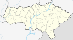
Rovnoje (Saratov)
| Urban-type settlement
Rovnoje Rovno
|
||||||||||||||||||||||||||||||||||
|
||||||||||||||||||||||||||||||||||
|
||||||||||||||||||||||||||||||||||
Rownoje ( Russian Ро́вное ; former German name "Seelmann" ) is an urban-type settlement in the Saratov Oblast in Russia with 4538 inhabitants (as of October 14, 2010).
geography
The place is a good 80 km as the crow flies south of the Saratov Oblast Administrative Center and about 10 km from the border with Volgograd Oblast on the left bank of the almost 10 km wide Volgograd reservoir of the Volga .
Rovnoje is the administrative center of Rowensky Rajons and the seat of the township of Rowenskoje gorodskoje posselenije, which also includes the villages of Alexandrowka (16 km southeast), Beregovoe (5 km southwest) and Novoprivolnoje (to the northeast) and the settlement Limanny (9 km south).
history
The place was founded on July 15, 1767 as a Volga German colony by Catholic settlers and was named Seelmann (Russian Зельманн , later also Зельман ) after one of the settlers . Catholics lived in Rovnoye. In the year the colony was founded, its population was only 251, in 1912 it was 8089. The colony was one of the largest and most important settlements on the left bank of the Volga.
The official Russian alternative name was Rownaja (Russian for "even", in relation to the location on the flat eastern, so-called meadow bank of the Volga). The colony belonged to the Ujesd Saratow of the Saratov governorate , from 1835 to the outsourced Ujesd Nowousensk , which was transferred to the newly formed Samara governorate in 1851 . From the end of the 19th century, only the Russian name was official.
On October 19, 1918, Rovnoje became the administrative seat of a Ujesd of the same name of the newly founded labor commune of the Volga Germans and remained so even after various administrative reorganizations and transformations of the Ujesde, first in cantons and later in Rajons of the Autonomous Republic (ASSR) of the Volga Germans . In 1927/1928 the canton and town were given the original German name Seelmann as the official name. In 1926 almost 90% of the population were ethnic Germans, compared to almost 75% in 1897. After the anti-Bolshevik uprising in the famine years and the "German" operation of 1937–1938, the German population suffered very high losses. In September 1941, on the orders of the Soviet Interior Ministry (NKVD), the Germans were deported to the Krasnoyarsk and Altaj regions and to the Omsk, Novosibirsk, Kustanaj, Pavlodar, Akmola and northern Kazakhstan regions. After the abolition of autonomy, the place was renamed again in 1942 . Since 1972 the place has had the status of an urban-type settlement.
Population development
| year | Residents |
|---|---|
| 1897 | 6816 |
| 1926 | 6218 |
| 1939 | 7363 |
| 1959 | 4431 |
| 1979 | 4448 |
| 1989 | 5559 |
| 2002 | 5267 |
| 2010 | 4538 |
Note: census data
Personalities
- Aloysius Kappes (1885–1937), pastor
- Jakow Jakowlewitsch Weber (1870–1958), artist
- Andrei Petrowitsch Dulson (1900–1973), linguist and linguist
- Viktor Klein (1909–1975), poet and writer
traffic
To the east, Rovnoje is bypassed by the Samara - Engels - Volgograd regional road, which bears the number 36R-00002 on the territory of Saratov Oblast. Via this road, the closest train station Anissovka can be reached, about 70 km north in Privolschski on the Saratov - Yershov - Oral ( Kazakhstan ) - Sol-Ilezk route . About the same distance is the east-northeast located Krasny Kut on the route (Saratow -) Puschkino ( Urbach station ) - Astrakhan , but only a largely unpaved runway leads to it (initially as 63K-00668).
Web links
Individual evidence
- ↑ a b Itogi Vserossijskoj perepisi naselenija 2010 goda. Tom 1. Čislennostʹ i razmeščenie naselenija (Results of the All-Russian Census 2010. Volume 1. Number and distribution of the population). Tables 5 , pp. 12-209; 11 , pp. 312–979 (download from the website of the Federal Service for State Statistics of the Russian Federation)


