Alexandrov Gai
| Village
Alexandrov Gai
Александров Гай
|
||||||||||||||||||||||||||||
|
||||||||||||||||||||||||||||
|
||||||||||||||||||||||||||||
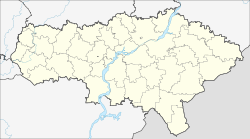
Alexandrow Gai ( Russian Алекса́ндров Гай ) is a village (selo) in the Saratov Oblast in Russia with 9728 inhabitants (as of October 14, 2010).
geography
The place is about 240 km as the crow flies southeast of the Saratov Oblast Administrative Center and about 15 km from the state border with Kazakhstan in the steppe landscape on the northern edge of the Caspian Depression , on both sides of the river Great Usen (Bolshoi Usen).
Alexandrov Gai is the administrative center of the Rajons Alexandrowo-Gaiski and seat of the 2016 six former municipalities resulting "municipal entity" Alexandrowo-Gaiskoje munizipalnoje obrasowanije with the status of a rural community (selskoje posselenije), among the total of 54 places. The largest towns besides Alexandrow Gai, each with over 500 inhabitants, are Kamyshki (20 km northwest), Kanawka (27 km north), Lukow Kordon (30 km northwest), Priusenski (13 km southeast) and Warfolomejewka (30 km southwest); 8 others have more than 100 inhabitants, 15 more than 10 inhabitants, 10 under 10 inhabitants and 15 no permanent residents (as of 2010).
history
The place was built from the late 17th century, as in the above by only a few nomadic living Kazakhs (until the 20th century as "Kyrgyz") is inhabited area from the serfdom settled fled Russian farmers. After the territories east of the Lower Volga were released for the settlement of Old Believers in 1762, Alexandrov Gai became one of their centers in the region and developed into an important trading point between Russians and steppe inhabitants. The village initially belonged to the Ujesd Saratow, from 1835 to the newly formed Ujesd Nowousensk of the Saratov governorate , which was transferred to the newly founded Samara governorate in 1851 .
The place experienced a further economic boom from 1895 after the introduction of an initially narrow-gauge railway line ( gauge 1000 mm) from Urbach (today Puschkino) - on the previously opened line from Pokrovsk (today Engels) to Uralsk (today Oral in Kazakhstan) - via Krasny Kut and Novousensk by the private Ryazan-Uralsker railway (converted to broad gauge 1906 to Krasny Kut, on the remainder until 1919, according to other information not until after 1922).
During the Russian Civil War between 1919 and 1921, starting from Alexandrow Gai, an extension of the railway line to the oil fields on the Emba River northeast of the Caspian Sea and a parallel pipeline were built. The project known as Algemba (by Al exandrow G ai and Emba ) was never ended and was abandoned because of its loss of importance after the end of the war.
In 1935 Alexandrow Gai became the administrative seat of a new Rajons spun off from the Nowousenski rajon . In 1960, the Rajon was temporarily back in the Nowousenski rajon; However, the place Alexandrow Gai received 1967 the status of an urban-type settlement . In 1973 the Rajon was restored. The place itself has been a village again since 1996.
Population development
| year | Residents |
|---|---|
| 1897 | 8449 |
| 1939 | 5454 |
| 1959 | 4763 |
| 1970 | 8088 |
| 1979 | 8779 |
| 1989 | 9611 |
| 2002 | 9993 |
| 2010 | 9728 |
Note: census data
traffic
Alexandrow Gai is the end of a railway line that branches off the main line (Saratov -) Urbach - Astrakhan in Krasny Kut, 152 km away . The route is mainly used for freight traffic, but after several years of cessation of passenger traffic, since 2015 there has been a connection to the Saratov Oblast Center again twice a week (as of November 2017).
On the last section from Nowousensk, the railway line to Alexandrow Gai is followed by the regional road 63K-00006, which branches off east of Pushkino from the regional road Engels - Yershov - border with Kazakhstan (formerly R236, part of European route 38 ).
Web links
Individual evidence
- ↑ a b Itogi Vserossijskoj perepisi naselenija 2010 goda. Tom 1. Čislennostʹ i razmeščenie naselenija (Results of the All-Russian Census 2010. Volume 1. Number and distribution of the population). Tables 5 , pp. 12-209; 11 , pp. 312–979 (download from the website of the Federal Service for State Statistics of the Russian Federation)

