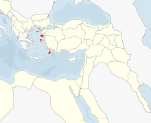
Vilayet Cezayir

Vilâyet Cezâyir-i Bahr-i Sefîd ("Province of the Islands of the White Sea"), briefly sometimes called Vilayet Dschesair , was the name of a province ( Vilâyet ) of the Ottoman Empire from 1864 to 1913, which essentially comprised the islands in the eastern part Half of the Aegean Sea and at times Cyprus . The name means "Islands of the White Sea". The “White Sea” means the Aegean Sea . The word Cezâyir (Arabic: Dschazāʾir ) means "islands" and is, for example, al-Jazāʾir, the original Arabic form of the city name Algiers . The Vilayet Cezayir must not be confused with the current Turkish name for Algeria ( Turkish Cezayir ). The Ottoman name for the Algerian province was Cezâyir-i Garp (Western Cezayir). The term West was no longer needed after the loss of the Aegean Islands and the sinking of the Vilayet Cezayir and was dropped.
Prehistory and Territorial Development
The forerunner of the Vilâyet was the eponymous Eyâlet Cezâyir-i Bahr-i Sefîd , the province of the Commander-in-Chief of the Ottoman Navy, the Kapudan Pasha . Originally, the position of commander-in-chief of the Ottoman Navy was linked to the position of governor of the sanjak Gelibolu . When the corsair Khair ad-Din Barbarossa was appointed Kaptan-i Derya , commander-in-chief of the fleet and given the rank of Beylerbeyi in 1533 , this area of dominion was given over to areas near Istanbul (Sanjak Kocaeli ), Aegean islands and areas in Greek Mainland From this then the Eyâlet developed. At the time of its greatest expansion, it included all the islands of the Aegean Sea except Crete with the sanjaks Andıra ( Andros ), Nakşa ( Naxos ), Midillü ( Mytilene ), Sakız ( Chios ) and Rhodes , the areas on both sides of the Dardanelles with the Troas , where there is with Gelibolu was the administrative center of Eyâlets, in Asia Minor, the Sanjak Kocaeli and Suğla (to Izmir ), in mainland Greece, the Sanjak Kavalla , Eğriboz ( Evia ), İnebahtı ( Nafpaktos , Lepanto) Karlıeli ( Akarnania ) and Mizistre ( Mistra ), continue in Egypt the cities of Alexandria , Damiette and Rosette and finally in Tunisia the cities of Mahdia and Monastir . Algeria, called Cezâyir-i Garp, was also part of it, but it increasingly slipped away from the authority of Kapudan Pasha and the Ottoman central government. In addition to the more and more nominal rule over the Eyâlets Tunis and Tripoli, the Kapudan Pascha's domain also temporarily included the Eyâlet Kıbrıs, which in addition to the island of Cyprus also included the Sanjaks Alanya , Silifke , Tarsus and Sis on the Anatolian mainland.
Through administrative measures up to the time of the Tanzimat and the independence of Greece gained in the Greek War of Independence as well as through the establishment of the autonomous principality of Samos , the provincial area was reduced . In 1849 Cyprus was added as a sanjak. Eventually the governorship was separated from the office of Kapudan Pasha.
When it was reorganized as Vilâyet in 1864, the province comprised the Sanjaks Biga , where the administrative center of the province was located with Kale-i Sultaniye, today's Çanakkale , Limni ( Lemnos ), Midilli (Mytilene), Sakız (Chios), Rhodes and Kıbrıs ( Cyprus). The province was further reduced: Semendirek ( Samothrace ) came to the Vilâyet Edirne , in 1870 Cyprus was separated as a separate province and in 1876 the Sanjak Biga was transferred to the Vilâyet Hüdavendigâr . The provincial capital was moved from Kale-i Sultaniye to Chios and later to Rhodes. In the 19th century there was a sharp increase in the population of the islands. Since the islands did not provide a sufficient basis for feeding the surplus population, there was a strong emigration to western Asia Minor.
After the Italian armed forces occupied the islands of the Dodecanese in the Italo-Turkish War and the other Aegean islands fell to Greece in the First Balkan War , the province came to an end on the eve of the First World War in 1913 . Today only the islands of Gökçeada (İmroz) and Bozcaada (formerly part of the Sanjak Limni) and the islands of the Ayvalık archipelago with the main island of Alibey (formerly parts of the Sanjak Midilli) belong to Turkey.
Statistical
In 1908 the province had an area of 6,900 km². Their population was 322,300.
The province was divided into 4 sanjaks and further into 16 kazas:
- Sanjak Rodos (Rhodes)
- Kaza Rodos
- Kaza Kaşot ( Kasos )
- Kaza Meis ( Kastelorizo )
- Kaza Sömbeki ( Symi )
- Kaza Kerpe ( Karpathos )
- Kaza İstanköy ( Kos )
- Sanjak Midilli ( Mytilene )
- Sanjak Sakız (Chios)
- Sanjak Limni (Lemnos)
- Kaza Limni
- Kaza Imroz
- Kaza Bozcaada
literature
- CE Beckingham: Ḏjazāʾir-i Baḥr-i Safīd. In: Encyclopaedia of Islam . Second Edition, Online Edition
- Halil İnalcık: Eyalet. In: Encyclopaedia of Islam . Second Edition, Online Edition
- S. Ozbaran: Ḳapudan Pasha. In: Encyclopaedia of Islam . Second Edition, Online Edition
Individual evidence
- ↑ Andreas Birken and Robert Meyer: Tübinger Atlas des Vorderen Orients (TAVO), Part B: History, The Ottoman period until 1918, sheet 8: Ottoman Empire. Provincial administration in the 17th and 18th centuries. Ludwig Reichert, Wiesbaden 1979, ISBN 978-3-88226625-2
- ↑ Mehmet Nasrullah et al. : Osmanlı Atlası. XX. Yüzyıl Başları. Hazırlayanlar: Rahmi Tekin / Yaşar Baş. Osmanlı Araştırmaları Vakfı, İstanbul 2003, ISBN 978-975-726834-5 (new publication of the Memâlik-i Mahrûse-i Şâhâneye Mahsus Mükemmel ve Mufassaâl Atlas, İstanbul, 1325/1907, in Latin script., Maps with original writing)
