
Villeta (Colombia)
| Villeta | ||
|---|---|---|
|
Coordinates: 5 ° 1 ′ N , 74 ° 28 ′ W Villeta on the map of Colombia
|
||
 Location of the municipality of Villeta on the map of Cundinamarca
|
||
| Basic data | ||
| Country | Colombia | |
| Department | Cundinamarca | |
| City foundation | 1551 | |
| Residents | 25,617 (2019) | |
| City insignia | ||
.svg) |
.svg) |
|
| Detailed data | ||
| surface | 140 km 2 | |
| Population density | 183 people / km 2 | |
| height | 850 m | |
| Waters | Río Villeta | |
| Time zone | UTC -5 | |
| City Presidency | Jhon Alexander Morera Gutiérrez (2016-2019) | |
| Website | ||
 |
||
 |
||
 |
||

Villeta is a municipality ( municipio ) in the department of Cundinamarca in Colombia .
geography
Villeta is located in the west of Cundinamarca and is the capital of the province of Gualivá . Villeta is located on the Río Villeta at an altitude of 850 meters in the Colombian Andes , 84 km from Bogotá . Adjacent to the church in the north Quebradanegra and Nimaima , east Nocaima and Sasaima , south Albán and Viani and west Guaduas . Villeta is divided into 38 quarters ( barrios ) in the urban part and 22 veredas (rural administrative units) in the rural part and the inspección Bagazal.
population
The municipality of Villeta has 25,617 inhabitants, of which 16,623 live in the urban part (cabecera municipal) of the municipality (as of 2019).
history
Villeta was founded in 1551 on the road between the Río Magdalena and Bogotá as Villa de San Miguel . The settlement was officially moved in 1644 as San Miguel de Guaduas in place of today's Guaduas . The original settlement was never completely abandoned. Villeta received villa (town) status in 1856 . The place was partially destroyed in a fire in 1888. In 1891 a bridge was inaugurated over the Río Villeta.
economy
The main industries of Villeta are agriculture (especially Panela is produced), grain trade , poultry production and tourism .
Worth seeing
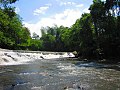
- Waterfalls Salto del Mico , Bocatoma de Bagazal and Salto Caiquero
- Plaza de la Panela , Panela center of the municipality
- Parque Principal , main square of Villeta
- Camino Real , historical route between Villeta and Guaduas
- Laguna Larga , lagoon

Salto del Mico
Bocatoma

Salto Caiquero

Plaza de la Panela


Web links
- Alcaldía de Villeta - Cundinamarca. Alcaldía de Villeta - Cundinamarca, accessed February 19, 2019 (Spanish, municipality website).
Individual evidence
- ^ Información del municipio. Alcaldía de Villeta - Cundinamarca, accessed February 19, 2019 (Spanish, information on the municipality).
- ↑ ESTIMACIONES DE POBLACIÓN 1985 - 2005 Y PROYECCIONES DE POBLACIÓN 2005 - 2020 TOTAL DEPARTAMENTAL POR ÁREA. (Excel; 1.72 MB) DANE, May 11, 2011, accessed on February 19, 2019 (Spanish, extrapolation of the population of Colombia).
- ↑ Pasado, presente y futuro. Alcaldía de Villeta - Cundinamarca, accessed February 19, 2019 (Spanish, information on the history of the municipality).
- ↑ Economía. Alcaldía de Villeta - Cundinamarca, accessed February 19, 2019 (Spanish, information on the municipality's economy).
- ↑ Sitios de interés. Alcaldía de Villeta - Cundinamarca, accessed on February 19, 2019 (Spanish, information on places of interest in the municipality).
Agua de Dios | Albán | Anapoima | Anolaima | Apulo | Arbeláez | Beltrán | Bituima | Bojacá | Cabrera | Cachipay | Cajicá | Caparrapí | Cáqueza | Carmen de Carupa | Chaguaní | Chía | Chipaque | Choachí | Chocontá | Cogua | Cota | Cucunubá | El Colegio | El Peñón | El Rosal | Facatativá | Fómeque | Fosca | Funza | Fúquene | Fusagasugá | Gachalá | Gachancipá | Gachetá | Gama | Girardot | Granada | Guachetá | Guaduas | Guasca | Guataquí | Guatavita | Guayabal de Síquima | Guaya Valley | Gutiérrez | Jerusalem | Junín | La Calera | La Mesa | La Palma | La Peña | La Vega | Lenguazaque | Machetá | Madrid | Manta | Medina | Mosquera | Nariño | Nemocón | Nilo | Nimaima | Nocaima | Pacho | Paime | Pandi | Paratebueno | Pasca | Puerto Salgar | Pulí | Quebradanegra | Quetame | Quipile | Ricaurte | San Antonio del Tequendama | San Bernardo | San Cayetano | San Francisco | San Juan de Río Seco | Sasaima | Sesquilé | Sibate | Silvania | Simijaca | Soacha | Sopó | Subachoque | Suesca | Supatá | Susa | Sutatausa | Tabio | Tausa | Tena | Tenjo | Tibacuy | Tibirita | Tocaima | Tocancipá | Topaipí | Ubalá | Ubaque | Ubaté | Une | Útica | Venecia | Vergara | Vianí | Villagómez | Villapinzón | Villeta | Viotá | Yacopí | Zipacón | Zipaquirá