Wagrain market
|
Wagrain ( capital of a market town ) village Wagrain market cadastral Wagrain |
||
|---|---|---|
|
|
||
| Basic data | ||
| Pole. District , state | St. Johann im Pongau (JO), Salzburg | |
| Judicial district | Sankt Johann im Pongau | |
| Pole. local community | Wagrain | |
| Coordinates | 47 ° 19 '57 " N , 13 ° 17' 51" E | |
| height | 838 m above sea level A. | |
| Residents of the village | 364 (January 1, 2020) | |
| Building status | 159 (2001) | |
| Area d. KG | 0.03044 | |
| Post Code | 5602 Wagrain | |
| Statistical identification | ||
| Locality code | 14066 | |
| Cadastral parish number | 55135 | |
| Counting district / district | Wagrain market center (50 423 000) | |
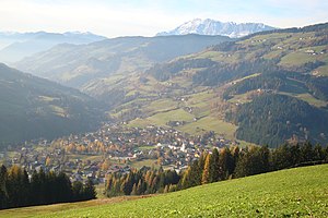
 Wagrain, core area around the market with the church floor in front, view in north-west direction towards the Hochkönig |
||
| Ortschaft as well as KG and ZSP Wagrain-Marktzentrum (1235 inhabitants, 373 buildings, status 2001) and addresses Markt (137, status 11/2014) also include (each different) shares in Hof and Hofmarkt Source: STAT : Ortverzeichnis ; BEV : GEONAM ; SAGIS |
||
Wagrain , as is customary in the area, market is a place in the Pongau in the state of Salzburg as well as Wagrain Markt, capital , locality and cadastral municipality of the municipality of Wagrain in the St. Johann district (Pongau) .
geography
The place is located about 7 kilometers east of St. Johann im Pongau . It is located in the Salzachpongau between the Hochgründeck -Stock of the Fritztaler Mountains ( Salzburg Slate Alps ) in the north and the Mosermandl group of the Radstädter Tauern ( Niedere Tauern ) in the south, in a valley widening of the Kleinarlbach to around 840 m above sea level. A. Height. The lower Kleinarlbach, from here also called Wagrainer Ache, flows westwards, towards the Salzach from the right at St. Johann . The valley of the Schwaighofbach goes north-west to Wagrainer Höhe ( 961 m above sea level ) and then eastwards towards Flachau and Altenmarkter Becken in Ennspongau . A small side valley , the Weberland, extends eastward . The actual Kleinarltal then leads south to the main Alpine ridge .
The B153 Wagrainer Straße Altenmarkt ( A8 in Flachau-Feuersang - St. Johann B311 ) leads through Wagrain , in the village the L214 branches off to Kleinarl .
The village of Wagrain Markt itself comprises almost 160 buildings with around 500 inhabitants (as of 2001), that is the center of the village and the Haid settlement to the south (belongs to the Hofmarkt KG).
The cadastral municipality Wagrain with 30.44 hectares, on the other hand, extends eastward from the core town and includes the areas between the B153 and the Wagrain parish church on the Kirchboden.
In addition to the market, the much more populous Kirchboden south-east and the location Goldanger on the north-east edge of the town are included in the counting district Wagrain market center , which with almost 400 buildings and more than 1200 inhabitants (as of 2001) represents the entire central town of the community, although some of them are already included the villages of Hofmarkt and Hof , respectively.
|
|
Hof (O & KG)
|
|

|
||
|
Vorderkleinarl (O and KG)
|
Hofmarkt
(O & KG) |
- ∗ Both also cadastral communities of St. Johann, but they do not border Wagrain, Hof and Vorderkleinarl slide between Tiefenbach and Schralehen west of the village.
History, infrastructure and sights
It is assumed that a Roman road ran here, even if not the main route of the Roman road Virunum - Iuvavum ( Zollfeld in Carinthia - Salzburg ), which seems secured in the Fritztal, but an important secondary or alternative route. The ruins and the parish church are probably built on the foundations of Roman watchtowers. The castle was around 1200 by the Gold Eggern built the place in 1243 as Wakrein first mentioned in a document, dated 1250 and today Wagrainer parish whose Rupert - patronage speaks for old age. The castle was already in 1322 to the throne between the succession dispute between Ludwig the Bavarian and Friedrich von Habsburg, the Fair destroyed the Goledegger were bayern friendly, the Salzburg Archbishop Friedrich but on the Austrian side. The latter pillaged the fortress, it was no longer built.
The place flourished in the early modern period, so it has been documented as a market town since 1592 , and in 1616 it got its own market church (St. Francis) . Iron ore mining then became important in the 18th century . The Counter-Reformation hit the place hard, however, over 80% of the inhabitants were expelled in 1731 ( exiles ).
Today Wagrain is one of the tourist centers of the Salzburger Sportwelt and Ski amadé , to which the former three-valley ski swing Flachau – Wagrain – St. Johann belongs as a regular area.
Web links
proof
- 50423 - Wagrain. Community data, Statistics Austria .
-
↑ a b c d e The Austrian map gives Wagrain (also the entry in Geonam Austria / AMAP online); SAGIS gives Wagrain market for the name property (the place); the addresses are mostly in market ;
Local, cadastral and counting district boundaries according to SAGIS. - ↑ cf. Michael Ellmer: Ortschronik Wagrain , Marktgemeinde Wagrain, 1993, p. 275 f.
- ↑ Ortschronik Wagrain , wagrain.salzburg.at (to the book)


