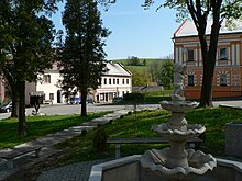
Ryžoviště
| Ryžoviště | ||||
|---|---|---|---|---|
|
||||
| Basic data | ||||
| State : |
|
|||
| Region : | Moravskoslezský kraj | |||
| District : | Bruntál | |||
| Area : | 1878 ha | |||
| Geographic location : | 49 ° 53 ' N , 17 ° 22' E | |||
| Height: | 595 m nm | |||
| Residents : | 599 (Jan. 1, 2019) | |||
| Postal code : | 793 56 | |||
| License plate : | T | |||
| structure | ||||
| Status: | local community | |||
| Districts: | 1 | |||
| administration | ||||
| Mayor : | Eva Lašáková (status: 2009) | |||
| Address: | nám. Míru 105 793 56 Ryžoviště |
|||
| Municipality number: | 597791 | |||
| Website : | www.ryzoviste.cz | |||
Ryžoviště , until 1947 Brunzeif (German: Braunseifen ) is a municipality in the Czech district of Bruntál ( Freudenthal district ).
Geographical location
Ryžoviště is located in the Sudetes , about 15 kilometers southwest of Bruntál ( Freudenthal ).
history
The place was founded in 1190 by miners looking for precious metals. The word soaps in the place name indicates the existence of deposits of minerals on the surface in the area where the place was founded. From 1295 the place had a hospital. 1318 Brunciv was raised to the city. After the decline of mining, weaving became the most important source of income in Braunseifen.
Through the Munich Agreement , Braunseifen was awarded to the German Reich in 1938 together with the Sudetenland ; in 1945 brown soap belonged to the district of Römerstadt in the administrative district of Troppau in the Reichsgau Sudetenland .
After the end of the Second World War and the expulsion of the Germans , the name was changed to Rýžoviště . The former city has now sunk to the status of a village.
Demographics
| year | Residents | Remarks |
|---|---|---|
| 1834 | 2,062 | |
| 1930 | 1,604 | |
| 1939 | 1,586 |
In 2006, 673 people lived in Ryžoviště.
Personalities
- Norbert Johann Klein (1866–1933), Bishop of Brno and Grand Master of the Teutonic Order
- Robert Schälzky (1882–1948), Grand Master of the Teutonic Order
literature
- Gregor Wolny : The Margraviate of Moravia. Described topographically, statistically and historically . Volume 5: Ölmützer Kreis . 2nd edition, Brno 1846, pp. 315-316, paragraph 3.
- Josef Schmid-Braunfels: History of the city of Braunseifen. Self-published by Braunseifen in 1910 (reprint and supplement. Heimatkreis Römerstadt (Altvater), Giessen 1979).
Individual evidence
- ↑ Český statistický úřad - The population of the Czech municipalities as of January 1, 2019 (PDF; 7.4 MiB)
- ↑ http://www.lexdata.cz/lexdata/sb_free.nsf/c12571d20046a0b20000000000000000/c12571d20046a0b2c12566d400718041?OpenDocument ( page no longer available , search in web archives ) Info: The link was automatically marked as defective. Please check the link according to the instructions and then remove this notice.
- ↑ Georg Schreiber, Mining in History, Ethos and Sacred Culture (Wiesbaden 1962), p. 102.
- ^ Gregor Wolny: The Margraviate of Moravia. Described topographically, statistically and historically . Volume 5: Ölmützer Kreis . 2nd edition, Brno 1846, pp. 315-316, paragraph 3.
- ^ A b Michael Rademacher: German administrative history from the unification of the empire in 1871 to the reunification in 1990. District Römerstadt (Czech. Rymarov). (Online material for the dissertation, Osnabrück 2006).


