
Burgstall Saufelsen
| Burgstall Saufelsen | ||
|---|---|---|
 Burgstall Saufelsen - View of the rock head with the castle site from the east (August 2010) |
||
| Creation time : | probably 12th century | |
| Castle type : | One-piece hilltop castle on the edge of the valley | |
| Conservation status: | Burgstall | |
| Standing position : | Ministeriale | |
| Place: | Kinding - Unteremmendorf - "Saufelsen" | |
| Geographical location | 48 ° 59 '18.3 " N , 11 ° 26' 13.7" E | |
| Height: | 492.4 m above sea level NN | |
|
||

The Burgstall Saufelsen is a former high medieval aristocratic castle at the upper edge of the Altmühltal above the village of Unteremmendorf in the municipality of Kinding in the Upper Bavarian district of Eichstätt in Bavaria , Germany . The Ministerialenburg has almost completely disappeared , only a ring moat and another moat have survived from the hilltop castle . The site is protected as a ground monument.
Geographical location
The former castle is located at 492.4 m above sea level. NN in the southern part of the Franconian Alb in the Altmühltal Nature Park . It is located about 100 meters above the Altmühl valley on a north-facing foothill of the Kühberg on the southern edge of the middle Altmühltal, about 285 meters south-east of the St. Nikolaus church in Unteremmendorf and about 3150 meters south-east of Kinding.
In the vicinity of the Saufelsen castle stable there are other former medieval castles, about 165 meters west of the Torfelsen castle stable with its impressive rock gate and another 1000 meters west of the Hubertusfelsen castle stable ; all three were probably castles of the same noble family. A few kilometers to the northeast, near the village of Paulushofen , is another castle stable, to the north is Hirschberg Castle , to the west is the Rumburg castle ruins near Enkering and to the south-southwest is Kipfenberg Castle above the market of the same name.
History of the castle
No precise information is yet available about the builder and when the castle on the Saufelsen was built. Like the two neighboring castles on the Torfelsen and the one on the Hubertusfelsen, it was probably built by the Emmendorfer family of ministers, first mentioned in 1119 . They were ministerials of the Hochstift Eichstätt . The village of Emmendorf, after which they were named, is located in the immediate vicinity of the former castle complex.
Since the Emmendorfer had several coats of arms , all three castles were probably in their possession, on each of which a side line of the family sat. The castles were probably abandoned after the family died out after 1506.
The place of the abandoned castle is densely forested, only the moat and small remains of the wall above the curtain wall have survived.
The Burgstall can be reached via a hiking trail. An information board about the Burgstall Saufelsen is also located on the neighboring Burgstall Torfelsen to the west.
The ground monument registered by the Bavarian State Office for the Preservation of Monuments as "Medieval Castle Stables" has the monument number D-1-7034-0153.
description
The former hilltop castle is located on the edge of the valley just a few meters below the plateau on a striking rock plateau protruding from the edge of the valley to the north into the valley of the Altmühl. This plateau drops a few meters vertically to the north and east (cover picture) and then, like the entire north side of Burgplatz, merges into a steep slope that descends to the valley floor. On the south side the plateau to the Kühberg rises slightly, so that a wide and deep ditch had to be dug there to protect the castle . The area of this relatively small spur castle is about 22 meters in length and 17 meters in width.
A few meters in front of the main trench is a 60 meter long section trench with an outer wall (Fig. 2). The slightly curved moat begins at the edge of the slope to the west of the castle stable and runs in an easterly direction. It ends at a dry small spring basin, this ditch probably served to secure this water point.
The actual castle on a rock head rising a few meters was secured by a U-shaped ring trench in the south of the complex (Fig. 3). A transverse wall at the eastern end of the trench shows that the trench was closed on this side by a trench wall. There are hardly any traces of buildings left on the castle grounds; on the eastern edge of the castle plateau there are remains of the foundation wall, presumably of the castle's ring wall .
Images of the castle stables

Photo 2: View into the section trench with the outer wall on the left (August 2010)
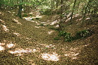
Image 3: View into the ring moat, on the left the castle hill of the castle site (August 2010)


literature
- Ingrid Burger-Segl: Archaeological Hikes, Volume 2: Middle Altmühltal . Verlag Walter E. Keller, Treuchtlingen 1993, ISBN 3-924828-57-1 , pp. 122-124.
- Brun Appel, Rudolf Böhm: Castles and palaces - Eichstätt district in the Altmühltal nature park . Published by the district of Eichstätt, Hercynia Verlag, Kipfenberg 1981, pp. 40–41.
Web links
- The Burgstall at Naturpark-Altmuehltal.de
Individual evidence
- ^ Location of the Burgstall in the Bavaria Atlas
- ↑ The Burgstall on the website of the Bavarian State Office for Monument Preservation (PDF; 183 kB)
- ↑ Ingrid Burger-Segl 1993, p. 124.
- ↑ List of monuments for kinding (PDF) at the Bavarian State Office for Monument Preservation (PDF; 145 kB)

Castles: Eibwang Castle | Eichstätt Residence | Summer residence Eichstätt | Hepberg Castle | Hexenagger Castle | Hirschberg Castle | Hofstetten Palace | Inching Castle | Kösching Castle | Lenting Castle | Neuenhinzenhausen Castle | Oberdolling Castle | Offendorf Castle | Pfünz Castle | Prandershof (Rablbauernhof) | Sandersdorf Castle | Schönbrunn Palace | Titting Castle | Wackerstein Castle | Westerhofen Castle
Castles and ruins: Adlerstein castle ruins | Altmannstein castle ruins | Arnsberg castle ruins | Brunneck castle ruins | Dollnstein castle ruins | Erlhof Castle | Ettling Castle Ruins (Burg Oettling) | Hagenhill Castle ruins | Kipfenberg Castle | Konstein castle ruins | Burg Krugsburg (Burg Krußburg) (dismissed) | Mörnsheim castle ruins | Morsbach Castle (exited) | Nassenfels Castle | Neuenstein Castle (exited) | Pfalzpaint castle ruins | Rauenwörth Castle (exited) | Rieshofen castle ruins | Rumburg castle ruins | Rundeck castle ruins (Stossenberg Castle) | Wellheim castle ruins | Wielandstein castle ruins | Willibaldsburg
Fortresses: Fort Prince Karl
Tower hill castles: Gensberg castle ruins | Rothenberg Tower Hill
Manor houses: Domherrensitz Späthscher Hof
Castle stables (lost unknown castles): Burgstall Althexenagger | Section fortification Arzberg | Section fortification Auf der Römerburg | Section fortification fire | Burgstall Bruckhof | Section fortification Burgstall (Altmannstein) | Section fortification The Kuchel | Burgstall Ettling | Burgstall Harlanden | Castle stable Hubertusfelsen | Section fortification Hünenring | Section fastening hat stones | Lime kiln section fixing | Section fortification Kesselberg | Section fortification Kirchberg | Section fortification Kottingwörth | Burgstall Lenting | Mallburg section fortification | Burgstall Michaelsberg | Section fortification Mörnsheim | Burgstall Obereichstätt | Burgstall Ottersdorf | Section fortification Pfünz | Burgstall Saufelsen | Ringwall Schellenburg | Section fortification Schneckenberg | Burgstall Torfelsen | Section fortification Walting | Castle stable Wieseck
Fortified churches: St. Michael (Biberbach) | St. Martin (Emsing) | Assumption of Mary (Gungolding) | St. Margaretha (Irfersdorf) | St. Ulrich (Kevenhüll) | Fortified church Kinding | St. Vitus (Kottingwörth) | Assumption of Mary (Möckenlohe) | St. Johannes Baptist (Stake Village) | St. Brigida (Preith) | St. John Evangelist (Walting) | St. Quirinus (Wolkertshofen)