
Dersim

Dersim ( Kurdish Dêrsim , Ottoman درسم, Armenian Տէրսիմ / Դերսիմ Tersim , Zazaisch Dêsım ) is the unofficial name of an area in Turkey today, it corresponds to the core of today's province of Tunceli . Despite the Tunceli Act of 1937 and the renaming to Tunceli, the name Dersim is common and politicized among the population. It is the region with the highest proportion of people of the Alevi faith in Turkey, and the majority of the inhabitants are Zazas . Before the genocide of the Armenians , numerous Armenians lived here . Many Armenians found refuge here during the genocide.
Naming
The popular derivation of the name from "silver gate" (Der = "door" / "gate" and Sim = "silver") is excluded. In 1847 the Sanjak Dersim was established and named after the Desim / Desimlu tribal association. According to Mehmet Yıldırım, the “r” in the name was caused by a reading and typing error by the Ottoman officials. From 1870 only the form Dersim appeared.
Demographics
Vitali Guinet, who gathered important information about the composition of the population of Dersim, divided the Dersimers into Kizilbasch , Muslims , Kurds and Evangelical and Gregorian Armenians. Towards the end of the 19th century, Antranig Yeritsyan, traveling in Dersim, also offers some information. Yeritsyan wrote that the derimers he met stated that they actually had Armenian roots. The French geographer and writer Élisée Reclus , who lived from 1830 to 1905, claimed that the Kizilbasch were only a small number of real Turks . Reclus stated that the (Dersim-) Kizilbash were considered a Christian denomination by the Muslims . At the beginning of the 1930s, a report made about Dersim was supposed to prove that the Dersimers were Turks.
For some researchers, the ancestors of the Dersimer come from a people who live in the mountainous area of Dailam ( Gilan ).
During the period of Sultan Abdülhamid II , the Dersimers were viewed from a religious point of view as "not on the right track". Therefore Nakschibendi Sheikhs were sent to Dersim , the establishment of a Tekke was ensured and a brief was prepared on July 3, 1896 inviting the people of Dersim to irschad . Then a report prepared together with the General Inspector of Anatolia, Müşir Şakir Paşa, and the commander of the 4th Ottoman Army , Mehmet Zeki Paşa, was presented to the Sublime Porte . The report, entitled "Briefing Regarding Dersim Islahatı Reform," consisted of four sections.
geography
Limits
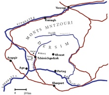
From a geographical point of view, Dersim is bordered by the Peri Çayı River in the east , the Munzur Mountains in the north, the Euphrates in the west and the Murat River in the south . From a policy perspective Dersim borders started on the north by the districts of Erzincan and Kemah the Erzincan province , in the northeast to the county Tercan the province of Erzincan, in part, to the county Palu province Elazig and at the district Kigi the province of Bingol , in the west to the county Kemaliye, Erzincan Province, Arapgir County, Malatya Province , and in the south the border is enclosed by Palu County, Elâzığ Province and Elâzığ and Keban Counties . The area covers a total of about 10,000 square kilometers (the province of Tunceli alone covers only 7,774 square kilometers). The old borders of Dersim, however, went from Varto , then in the north to İmranlı and Zara and in the west even to Malatya .
West and East Dersim
Historians divide the Dersim area into two areas:
- East Dersim; with Mazgirt , Kiğı , Çarsancak (Peri), Nazımiye and Pülümür as well
- West Dersim; with Hozat , Çemişgezek , Ovacık and Kemah
mountains
-
Munzur Dağları
- Akbaba Tepesi (3462 m)
- Kaf Tepesi (3369 m)
- Katır Tepesi (3129 m)
- Bağır Paşa Dağı (3282 m)
- Sürünbaba Tepesi (2192 m, Karaoğlan)
- Çal Dağı (2342 m, Kabataş)
- Mercan Dağları (Erzincan)
- Karasakal Dağları (Tunceli - Pülümür)
- Karaoğlan Dağı (Tunceli)
- Avcı Dağları (Pülümür)
- Yılan Dağı (2950 m, Yukarı Umutlu)
- Sarıçiçek Tepesi (1871 m, Pertek)
- Kırklar Dağı (1897 m, Mazgirt)
- Topatan Tepesi (2192 m, Hozat)
- Karagöl Dağları
- Palandöken Dağları
- Karaboğa Dağları
- Gökdere Dağları
- Kurt Tepesi (1978 m, Gökdere)
- Akçakara Dağları
- Koz Tepesi (2264 m)
- İnceburun Dağları
- Tecer Dağları
- Otlukbeli Dağları
- Köse Dağları
- Esence Dağları
- Esence Tepesi (3549 m)
- Şeytan Dağları
- Kaplıkaya Tepesi (Elâzığ)
- Mastar Dağı (Elâzığ)
- Küp Dağı (2088 m)
- Şerafeddin Dağları
- Şerafeddin Tepesi (2544 m)
- Dallı Tepesi (3034 m)
- Şahin Tepesi (2675 m)
- Şehit Tepesi (1532 m)
- Askerçayırı Tepesi (1592 m)
-
Bingöl Dağları
- Dağkale Tepesi (3193 m)
- Şakşak Tepesi (3057 m)
- Karakaya Dagı (3115 m)
- Buzgölü Tepesi (3162 m)
- Köhmen Dağı (3045 m)
- Sivri Tepesi (1931 m)
- Kurtlu Tepesi (2711 m)
- Güneşönü Tepesi (2078 m)
- Çengelli Dağı (2596 m)
- Güneydoğu Toroslar
- Dördük Dağları (Malatya)
- Şakşak Dağları (Malatya)
- Ulubaba Dağı (Malatya)
- Ziyaret Tepesi (2000 m)
Rivers and streams
- Munzur Çayı
- Tahar
- Mozat Deresi
- Pülümür Çayı
- Peri Suyu
- Murat Nehri
- Çaltı Çayı
- Karabel Çayı
- Tatlı Çayı
- Nih Çayı
- Kozluk Çayı
- Kekikpınar Çayı
- Goynuk Suyu
- Tuzla Çayı
- Gülan Çayı
- Karabudak Çayı
- Çardaklı Deresi
- Çayönü Deresi
- Kaynarca Deresi
- Bayram Deresi
Dams
Passports
- Çimento Geçidi (Kemaliye)
- Karababa Geçidi (Arapgir)
- Övdelik Geçidi (Arapgir)
- Örtülü Geçidi (Arapgir)
- Tırnık Geçidi (Palu)
- Çobantaş Geçidi (Göynük)
- Kurucu Geçidi (Karakoçan - Bingöl arası)
- Buğlan Geçidi (Solhan)
- Kovalık Geçidi (Başköy)
- Sip liqueur Geçidi (Erzincan)
- Kolçekmezdağ Geçidi (Erzincan)
- Sakaltutan Geçidi (Refahiye - Erzincan arası)
- Arpayazbeli Geçidi (Refahiye)
- Sünübeli Geçidi (Gümüşakar)
- Çorakboğazı Geçidi (Karacaören)
- Karşar Geçidi (Divriği)
- Karabel (Beypınarı - Beulucan arası)
- Kızbeli (Çetinkaya - Beypınarı arası)
- Kızıldağ Geçidi (İmranlı - Refahiye)
- Kubbe Geçidi (Çolaklı)
- Kömürhan Geçidi (Kale)
- Koç Geçidi (Sivrice)
history

The Urartians are believed to be the oldest inhabitants of the area . The region has historically been under the rule of various dynasties and empires such as Urartu , the Achaemenids , Rome , Byzantium , Seljuk , the Eretna Beyliği , the Ottomans and Turkey. The first Kurdish dynasty in Dersim was the Cemisgezek dynasty founded in the 12th century. Smaller Kurdish dynasties such as Sagman and Koschan were also added. After the region fell completely into the hands of the Muslim Ottomans in the 14th century , Alevi Kurds withdrew to the high mountains of Dersim and lived in an autonomous society administered by the Kurdish tribes.
The province gained great fame through the Dersim uprising in 1937/38, in the course of which tens of thousands of people died or were forcibly resettled. After that, the story is identical to that of the province of Tunceli. Efforts have been made in recent years to reintroduce the old name Dersim.
Web links
Individual evidence
- ↑ Cap. L. Molyneux-Seel: A Journey in Dersim . In: Geographical Journal , 44/1 (1914), pp. 49-68.
- ↑ Sevan Nişanyan : Adini unutan Ülke . Türkiye'de Adı Değiştirilen Yerler Sözlüğü. Istanbul 2010, p. 315.
- ↑ a b Mehmet Yıldırım, Desimlu Aşireti'nden Dersim Sancağı'na . ( Memento of the original from December 7, 2012 in the Internet Archive ) Info: The archive link was inserted automatically and has not yet been checked. Please check the original and archive link according to the instructions and then remove this notice. (PDF) Tunceli Üniversitesi Sosyal Bilimler Dergisi Cilt 1, Sayı 1, Güz 2012, pp. 23–37.
- ↑ Antranig: Dersim Seyahatname . Aras yayıncılık, p. 123
- ↑ Antranig: Dersim Seyahatname . Aras y., P. 122
- ↑ İbrahim Yılmazçelik: Dersim Sancağının Kurulmasından Sonra Karşılaşılan Güçlükler ve Dersim Sancağı ile İlgili Bu Dönemde Yazılan Raporlar (1875–1918) . (PDF; 6.7 MB) In: Otam Volume 28, Autumn 2010 edition.
- ↑ Nazmi Sevgen: Zazalar ve Kızılbaşlar: Coğrafya-Tarih-Hukuk-folklore-Teogoni , Kalan Yayınları, Ağustos 1999, ISBN 975-8424-00-9 , p. 12
- ↑ Nazmi Sevgen (1890 - 1980): Dersim uzumanı olan emekli Jandarma Yarbayı.
- ↑ Ahmet Hezarfen, Cemal Şener: Osmanlı Belgeleri'nde Dersim Tarihi (Osmanlıca-Türkçe 50 Adet Orjinal Belge) . Label Yayınları, Mart 2003, İstanbul, ISBN 975-8565-06-0 , p. 4.
- ↑ Dersim maddesi. In: Türk Ansiklopedisi , Cilt XIII, Milli Eğitim Basımevi, Ankara, 1966, p. 109.
Coordinates: 39 ° 9 ′ 10.8 ″ N , 39 ° 28 ′ 15.6 ″ E