
Dhar (district)
| Dhar District धार जिला |
|
|---|---|

|
|
| State | Madhya Pradesh |
| Division : | Indore |
| Administrative headquarters : | Dhar |
| Area : | 8153 km² |
| Residents : | 2,184,672 (as of 2011) |
| Website : | Dhar District |
The district of Dhar ( Hindi : धार जिला) is a district of the central Indian state of Madhya Pradesh with about 2.3 million inhabitants. The administrative and economic center is the city of Dhar with a population of around 100,000 . The district was established in 1947.
geography
The district of Dhar, bounded in the south by the Narmada River , is located in the southwest of the state of Madhya Pradesh in the Vindhya Mountains at heights of 150 to 600 m above sea level. d. M. It is bordered to the north by the district of Ratlam, to the northeast by the district of Ujjain , to the east by the district of Indore , to the south by the district of Barwani , to the southwest by the district of Alirajpur and to the west by the district of Jhabua . Several tributaries of the Narmada have their source in the Vindhya range. The most important cities are Dhar (approx. 100,000), Kukshi (approx. 40,000), Manawar (approx. 35,000) and Badnawar (approx. 25,000).
population
Official population statistics have only been kept and published since 1991.
| year | 1991 | 2001 | 2011 |
| Residents | 1,367,412 | 1,740,329 | 2,185,793 |
Hindus dominate the rural villages (approx. 95%); There is also a not inconsiderable number of Muslims in the cities (approx. 5% of the total population). In the decade between 2001 and 2011, the population grew by around 20% to over 2 million, with the male population exceeding the female population by around 12%. About 81% of the population lives in rural villages; a third of the people (mostly women) are considered illiterate. Mostly Hindi is spoken . The districts of Dhar and Jhabua have high proportions of the Bhil population.
economy
Agriculture has traditionally played the dominant role in the district's economic life; The main crops are wheat and rice as well as legumes (lentils, peas, etc.), oilseeds , cotton, etc. Crafts, trade and small industrial and service companies have settled in the cities. The city of Pithampur in the east of the district has developed into a medium-sized industrial location .
History and sights
The area around Dhar belonged to the Paramara Empire in the Middle Ages , but was only of political or cultural importance under King Bhoja (r. 1010 / 21-1065). The Islamic invasion of northern India initially left the region untouched, but in the 13th century it was conquered by the Sultanate of Delhi . At the beginning of the 15th century, the local governor Dilawar Khan went into business for himself and his son Hoshang Shah continued his father's policy of autonomy; Mandu became the new capital of the empire. In 1560 the Mughal ruler Akbar I conquered the region. In the phase of the decline of the Mughal Empire in the 18th century, the Marathas took power first , followed by the British . In 1728 the princely state of Dhar was established , which lasted until India's independence (1947).

Dhar , fort and city
Mandu , palace

Mandu, Hindola Palace

Mandu, Jahaz Mahal

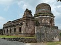
Mandu, Hoshang Shah mausoleum

Mandu, Friday Mosque ( Jama Masjid )

.jpg)

.jpg)


Web links
Individual evidence
- ↑ Dhar and surroundings - map with altitude information
- ^ Dhar District - Geography
- ↑ Dhar District - Map and Quick Facts
- ↑ Dhar District - Census 1991 to 2011
- Jump up ↑ Dhar District - Religious Affiliation
- ^ Dhar District - Census 2011
- ^ Agriculture in Madhya Pradesh
- ^ Dhar District - Industrial Company in Pithampur
- ^ Dhar District History
- ↑ Dhar District - Attractions
- ↑ Dhar District - Sights ( Memento of the original from November 14, 2016 in the Internet Archive ) Info: The archive link was automatically inserted and not yet checked. Please check the original and archive link according to the instructions and then remove this notice.
Small text

Agar Malwa | Alirajpur | Anuppur | Ashoknagar | Balaghat | Barwani | Betul | Bhind | Bhopal | Burhanpur | Chhatarpur | Chhindwara | Damoh | Datia | Dewas | Dhar | Dindori | Guna | Gwalior | Harda | Hoshangabad | Indore | Jabalpur | Jhabua | Katni | Khandwa | Khargone | Mandla | Mandsaur | Morena | Narsinghpur | Neemuch | Panna | Raise | Rajgarh | Ratlam | Rewa | Sagar | Satna | Sehore | Seoni | Shahdol | Shajapur | Sheopur | Shivpuri | Sidhi | Singrauli | Tikamgarh | Ujjain | Umaria | Vidisha