Honor (Solingen)
|
to honor
City of Solingen
Coordinates: 51 ° 11 '55 " N , 7 ° 3' 35" E
|
||
|---|---|---|
| Height : | about 190 m | |
| Postal code : | 42653 | |
| Area code : | 0212 | |
|
Location of honor in Solingen |
||
|
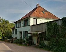
View over Ehren
|
||
Ehren is a court on the western edge of the Gräfrath district of the Bergisch city of Solingen . It consists of two separate living spaces, Ehren and Ehrener Mühle.
geography
Ehren is slightly elevated north of the Nümmener Bach in the west of the Gräfrath district on the mountain, which rises to the Gräfrath Parkfriedhof in the north at over 230 meters above sea level . To the east is the Nümmen court , to the west is the Ehrener Mühle .
etymology
Attempts to interpret the name of the court have so far been unsuccessful. According to Hans Brangs, the name could have come from the fact that the estate could possibly have been created in honor of Saint Catherine . However, all attempts to link the court name with membership of the Gräfrath monastery fail because the name has existed as a field name since the 14th century.
According to Dittmaier , it is therefore more of an old phonetic form of the tree name maple : Urgerm. * ahira- , dan. aer , in Rhenish dialects also ire , eren , berg. hear .
history
The living space southwest of Ehren, known today as Ehrener Mühle, was first mentioned in a document in 1374 and was the location of a water mill on the Nümmener Bach until the 20th century . Up until the 19th century, this courtyard was called Zur Große Ehren , while today's Ehrenberg was called Zur kleine Ehren . The latter appears for the first time on the map by Erich Philipp Ploennies from 1715 and is listed there as Kl. Irren . It remains unclear whether the two farms used to belong together and whether Ehren was also owned by the Gräfrath monastery.
Honor belonged to the Honschaft Ketzberg within the office of Solingen . The topographical survey of the Rhineland from 1824 shows the Ehrener Mühle with the mill symbol and honors as Zum Ehren . The Prussian first recording from 1844 record the living spaces as Ehrener M. , also with a mill symbol, and honors .
In 1815/16 there were 49 residents in the village. In 1830 Ehren belonged to the mayor's office in Gräfrath , 59 people lived in the village at that time. In 1832 Honor was part of the Honschaft (Ketz-) Berg within the Gräfrath mayor . The place, which was categorized as a court town according to the statistics and topography of the Düsseldorf administrative district , had nine residential buildings, five factories or mills and eleven agricultural buildings at that time. At that time 69 residents lived in the place, four of them Catholic and 65 Protestant denominations. The municipality and estate district statistics of the Rhine Province list the place in 1871 with eleven houses and 74 inhabitants. In the municipality lexicon for the province of Rhineland in 1885 nine houses with 82 inhabitants are given. In 1895 the district had 14 houses with 95 inhabitants, in 1905 15 houses and 108 inhabitants are given.
With the town union of Groß-Solingen in 1929 Ehren became a district of Solingen. At the beginning of the 2000s, a rainwater retention basin was built by the Bergisch-Rheinischer Wasserverband south of Ehren, at the location of the old Ehrener Kotten in the valley of the Nümmener Bach .
swell
- ↑ Hans Brangs: Explanations and explanations of the corridor, place, yard and street names in the city of Solingen , Solingen 1936
- ↑ a b Marina Alice Mutz: Honors. In: Time Track Search. Retrieved May 14, 2016 .
- ^ Heinrich Dittmaier : settlement names and settlement history of the Bergisches Land. Schmidt, Neustadt ad Aisch 1956 (magazine of the Bergisches Geschichtsverein, 74 - parallel edition as a publication by the Institute for Historical Regional Studies of the Rhineland at the University of Bonn), p. 187
- ^ A b Friedrich von Restorff : Topographical-statistical description of the Royal Prussian Rhine Province , Nicolai, Berlin and Stettin 1830
- ↑ a b Johann Georg von Viebahn : Statistics and Topography of the Administrative District of Düsseldorf , 1836
- ↑ Königlich Statistisches Bureau (ed.): The communities and manor districts of the Prussian state and their population . The Rhine Province, No. XI . Berlin 1874.
- ↑ Königliches Statistisches Bureau (Prussia) (Ed.): Community encyclopedia for the Rhineland Province, based on the materials of the census of December 1, 1885 and other official sources, (Community encyclopedia for the Kingdom of Prussia, Volume XII), Berlin 1888.
- ↑ Königliches Statistisches Bureau (Prussia) (Ed.): Community encyclopedia for the Rhineland Province, based on the materials of the census of December 1, 1895 and other official sources, (Community encyclopedia for the Kingdom of Prussia, Volume XII), Berlin 1897.
- ↑ Königliches Statistisches Bureau (Prussia) (Ed.): Community encyclopedia for the Rhineland Province, based on the materials of the census of December 1, 1905 and other official sources, (Community encyclopedia for the Kingdom of Prussia, Volume XII), Berlin 1909.
- ↑ Marina Alice Mutz: Ehrener Kotten. In: Time Track Search. Retrieved May 14, 2016 .


