
Canterbury (region)
|
Canterbury Region Environment Canterbury Māori: Kaunihera Taiao ki Waitaha |
|
| Geographical location | |
  |
|
| Photo from Canterbury Region | |
 Canterbury west of Geraldine |
|
| Local authority | |
| Country | New Zealand |
| island | South island |
| Local authority | region |
| Council | Environment Canterbury Regional Council |
| Headquarters of the administration | Christchurch |
| founding | 1989 |
| Telephone code | +64 (0) 3 |
| Website | www.ecan.govt.nz |
| geography | |
| Region ISO | NZ-CAN |
| Coordinates | 43 ° 32 ' S , 172 ° 38' E |
| Highest elevation | 3724 m |
| surface | 44 508 km 2 |
| Residents | 539 436 (2013) |
| Population density | 12.12 inhabitants per km 2 |
| Statistical data | |
| Public revenue | NZ $ 168.3 million (2015) |
| Public expenditure | NZ $ 155.3 million (2015) |
| Number of households | 238 383 (2013) |
| Ø income | NZ $ 30,100 (2013) |
| Māori population | 5.8% (2013) |

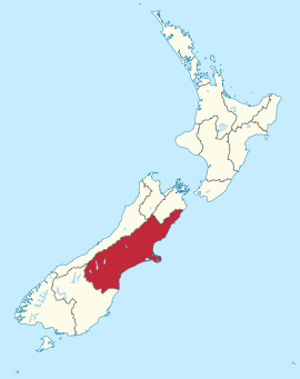
The Canterbury Region is an administrative region on the South Island of New Zealand . In terms of area, it is the largest region in the country. The region administration, which is based in Christchurch , renamed the region in 1998 with Environment Canterbury . The council has been called the Environment Canterbury Regional Council since then . On the government side, the region is still called Canterbury Region and the Canterbury Region Council .
geography
Geographical location
The Canterbury Region covers the central eastern part of the South Island of New Zealand with 44,508 km² of pure land. With 539,436 inhabitants in 2013, Canterbury is the second largest region in terms of population and has a population density of 12.1 people per km².
Canterbury is located between the regions of Otago in the southwest, West Coast in the west and the Marlborough District in the northeast of the South Island. The eastern and south-eastern borders of the region are formed by the Pacific Ocean . In terms of landscape, the west of the region is characterized by the alpine mountains of the New Zealand Alps , while the middle east is characterized by the wide plains of the Canterbury Plains . The south and north of the region are also located in a mountain landscape.
From south to north, some of the region's largest lakes include: Lake Ohau , Lake Benmore , Lake Aviemore , Lake Pukaki , Lake Tekapo , Lake Coleridge, and Lake Ellesmere . The most important rivers are listed in the same direction: the Waitaki River , the Rangitata River , the Rakaia River , the Waimakariri River , the Ashley River , the Hurunui River and the Clarence River .
In the borders of the Canterbury region is also the highest mountain in New Zealand, the 3724 m high Aoraki / Mount Cook as well as the adjacent glaciers, Hooker Glacier , Tasman Glacier and Murchison Glacier . The Mount Cook National Park and Arthur's Pass National Park is also one of the region.
The largest cities in the region are by far Christchurch with 341,469 inhabitants, followed by Timaru with 27,051, Ashburton with 18,471, Rangiora with 15,821, 9555 inhabitants Rolleston and Kaiapoi with 9255 inhabitants.
climate
The climatic conditions of the Canterbury region are quite different due to its location, extent and landscape. While alpine weather conditions prevail in the west, the east is on the leeward side of the mountains with correspondingly lower rainfall and higher temperatures. In the alpine regions, for example, annual precipitation above 2000 mm must be expected, whereas the eastern regions are correspondingly dry at 400 to 800 mm. In a north-east-south-west band on the east side of the alpine mountains, precipitation is between 900 and 1400 mm per year.
The average daytime temperatures in summer are between 19 ° C and 24 ° C in the eastern plains and between 11 ° C and 17 ° C in the mountain regions, depending on altitude and geographical location. In winter, the mountains are all in the single-digit minus range and the plains between 1 ° C and 4 ° C depending on the location. The northeastern side of the Banks Peninsula and the northeastern coastline have average winter daily temperatures of around 4–5 ° C. The duration of sunshine is between 1900 and 2100 hours per year in the east and decreasing to 1500 hours towards the west.
history
The colonization of the region was planned in 1848 by Edward Gibbon Wakefield and John Robert Godley on behalf of the Church of England . Settlement by European immigrants began around 1850. During this time, many government and church buildings in neo-Gothic style were built by Benjamin Mountfort , one of New Zealand's most famous architects .
In 1853 New Zealand was divided into new provinces and the Province of Canterbury was formed on the South Island . It stretched in the central part of the South Island from the west coast to the east coast and from the Waitaki River in the south to the Hurunui River in the north. But in 1868, after three years of tensions between the settlements on the west and east coasts, they divided and the west became independent as the County of Westland . In 1876 the provinces were dissolved and the province of Canterbury was divided into several counties . It was not until 1979 that a Canterbury United Council was formed to take on certain tasks for the region.
As part of the administrative reform of 1989, the Canterbury Regional Council was formed and newly established from 33 councils and local authorities in November of that year . The political boundaries of the region were taken over unchanged from the previous local authority from 1876. The newly formed Canterbury Regional Council organized its work together with the likewise newly formed nine districts and a city, which act as territorial authority independently and independently of the Regional Council .
population
Population development
Of the 539,436 inhabitants of the region in 2013, 41,910 inhabitants were of Māori origin (7.8%). This means that 7.0% of the country's Māori population lived in the Canterbury region . The median income for the population in 2013 was NZ $ 30,100 compared to NZ $ 28,500 national average.
Origin and languages
When asked about ethnic group membership in the 2013 census, 86.9% said they were European, 8.1% said they had Māori roots, 2.5% came from the islands of the Pacific and 6.9 % came from Asia (multiple answers were possible). 19.6% of the population said they were born overseas. 1.7% of the population spoke Māori as the second most common language after English, among the Māori it was 14.4%.
politics
administration
The Canterbury Region has a board of directors called Environment Canterbury Regional Council , which is led by a chairman . In the Council sit seven elected councilors (council members) that a total of four so-called constituencies represented (constituencies). In the following, these are the constituency of Christchurch with four councilors and the constituencies of North Canterbury , Mid-Canterbury and South Canterbury with one councilor each . The council members, who choose the chairman from their ranks, are re-elected every three years.
Furthermore, the region is divided into nine districts and one city, each with its own council :
- Kaikoura District
- Hurunui District
- Waimakariri District
- Selwyn District
- Ashburton District
- Mackenzie District
- Timaru District
- Waimate District
- Waitaki District (partially, approx. 55%)
While the regional administration is responsible for the inland and coastal waters, for the ports, for land, air, erosion, disaster control, transport planning and regional development, the administrations of the districts are responsible for all other concerns of the citizens and the matters which are in a Local authority must be regulated.
economy
The Canterbury Plains are regarded as the granary of New Zealand and south of Christchurch there are extensive core and stone fruit plantations. Canterbury is the fourth largest wine growing area in New Zealand . Mainly Chardonnay and Pinot Noir , but also Riesling and Sauvignon Blanc are grown here. In 2009, together with the capital Christchurch , it was included in the “ Great Wine Capitals ” network, a global marketing organization for wine and related tourism offers.
Infrastructure
traffic
The region is connected by the New Zealand State Highway 1 , which begins in Bluff on the south coast and on its way connects the cities of Invercargill and Dunedin with Christchurch and runs through the region along the coast to the north. In parallel, the South Island Main Trunk Railway runs in the same direction and connects the region with the southern and northern parts of the South Island. From State Highway 1 branch off in a westerly direction, State Highways 7 , 73 and 8 cross the region in a westerly direction and connect it to the west coast .
The Canterbury region has two important ports, Timaru Harbor and Lyttelton Harbor , the latter known as a natural harbor . In addition to a few small regional airports in the region, west of the city center of Christchurch is the only international airport in the South Island that is also important beyond the borders of the region.
Events
In 1991 the asteroid (3563) was named Canterbury after the region.
In 2010, 2011 and 2016 three major earthquakes occurred in the region: on September 4, 2010 the Darfield earthquake , on February 22, 2011 the Christchurch earthquake with numerous fatalities and most recently on November 14, 2016 the Kaikoura earthquake that killed two people.
Web links
- Homepage . Canterbury Regional Council,accessed August 12, 2016.
Individual evidence
- ↑ a b c d e Canterbury Regional Council . In: Local Councils . Department of Internal Affairs , accessed August 12, 2016 .
- ↑ a b c d 2013 Census QuickStats about a place : Canterbury Region - Population and dwellings . Statistics New Zealand , accessed August 12, 2016 .
- ↑ Reports (literature list). (PDF 28 kB) Aquatic Ecology Limited , accessed on April 25, 2017 (English).
- ↑ a b Topo250 maps . Land Information New Zealand , accessed August 12, 2016 .
- ↑ National Parks . Department of Conservation , accessed July 16, 2016 .
- ↑ GR Macara : The Climate and Weather of Canterbury . In: NIWA Science and Technologies Series . 2nd Edition. Number 68 . National Institute of Water and Atmospheric Research , 2016, ISSN 1173-0382 , p. 12, 16, 24, 29 (English, online PDF 6.6 MB [accessed on August 11, 2016]).
- ^ Alexander Hare McLintock : Canterbury Province and Province District . In: An Encyclopaedia of New Zealand . Ministry for Culture & Heritage , April 23, 2009, accessed August 12, 2016 .
- ↑ John Wilson : Canterbury region - Politics and government . In: Te Ara - the Encyclopedia of New Zealand . Ministry for Culture & Heritage , December 15, 2014, accessed August 12, 2016 .
- ^ Your Council . Canterbury Regional Council , accessed August 12, 2016 .
- ↑ 2013 Census QuickStats about a place : Canterbury Region - Cultural diversity . Statistics New Zealand , accessed August 12, 2016 .
- ↑ Map: Canterbury region - Environment Canterbury 2016 constituencies . (PDF 389 kB) Canterbury Regional Council , archived from the original on February 15, 2016 ; accessed on April 3, 2018 (English, original website no longer available).
- ↑ 2016 Local Government Elections . Canterbury Regional Council , archived from the original on August 12, 2016 ; accessed on April 3, 2018 (English, original website no longer available).
- ^ Councils in Canterbury . Canterbury Regional Council , accessed April 3, 2018 .
- ↑ Glossary . In: Local Councils . Department of Internal Affairs , accessed August 12, 2016 .
- ↑ Minor Planet Circ. 18306
North Island : Northland | Auckland * | Waikato | Bay of Plenty | Gisborne * | Hawke's Bay | Taranaki | Manawatu-Wanganui | Wellington
South Island : Tasman * | Marlborough * | Nelson * | West Coast | Canterbury | Otago | Southland
Other islands: Chatham Islands *