
Esterel (mountains)
| Esterel | |
|---|---|
 Location of the Esterel in France |
|
 Mountains in the Esterel |
|
| Highest peak | Mont Vinaigre ( 618 m ) |
| location | France |
| Coordinates | 43 ° 29 ′ N , 6 ° 51 ′ E |
| rock | Volcanite |
| Age of the rock | 250 million years ( Permian ) |
| surface | 320 km² |

The Esterel (French: Massif de l'Esterel ) is a low mountain range in France , located between Cannes and Saint-Raphaël on the Côte d'Azur . It is a popular hiking area. The highest point is the Mont Vinaigre with 614 m . The mountains are known for their red rock formations.
Surname
There are several hypotheses as to the origin of the name. He is derived
- from the pre-Latin ester ("steep rock, rock gorge"), cf. for this the Basque village Estérençuby or the Estergebirge in the Bavarian Prealps ,
- from the Latin sterilis ("sterile"), referring to the poor soils or
- from the name Sueltiri of a Celtoligur tribe that inhabited the area.
In Provencal the mountain is called Esterèu .
geography
The Esterel is located in the south-east of France and jumps into the Mediterranean between Saint-Raphaël ( Var ) and Mandelieu-la-Napoule ( Alpes-Maritimes ). It is separated from the Maures massif by the Argens valley. Its relief is fissured and heavily washed out. The coast is steep and rich in incisions ( calanques ).
Of its area of 320 km², 130 km² are under protection. 60 km² of forest area are subordinate to the Office national des forêts.
The main peaks are
- Mont Vinaigre (618 m) (municipality of Fréjus )
- Les Suvières (558 m)
- Pic de l'Ours (492 m)
- Cap Roux (453 m)
- Pic d'Aurelle (322 m)
- Rastel d'Agay (287 m)
The climate is Mediterranean with hot and dry summers and mild, humid winters. The climate is humid , especially in autumn , as the nearby Mediterranean retains heat, and the rains can be torrential and lead to severe erosion .
geology
The Esterel is of Hercynian origin. At the end of the Paleozoic Era about 250 million years ago (in the Permian ), intense volcanic activity that lasted 30 million years produced large amounts of basalt and rhyolite . In the Mesozoic, the massif was subject to severe erosion. In the Cenozoic it was tilted towards the Mediterranean by the Alpid uplift.
The massif consists for the most part of rocks with a porphyry structure , especially rhyolites , which give it its reddish basic color. The latter is locally interrupted by veins of bluish esterellite , which only occurs here. Significant faults extend from east to west.
fauna and Flora
In the Esterel, among other things, red deer , wild boars and hares can be found, as well as pheasants and partridges , Greek tortoises and various types of lizards , singing cicadas and butterflies .
Tree species native to the Esterel are maritime pines , pines , cork oaks and olives . Eucalyptus of Australian origin have been naturalized but are considered invasive . The maquis consists of lavender , juniper , western strawberry tree , gorse , silver acacia (a naturalized species), rockrose , myrtle , rosemary , thyme and heather .
On the southern slopes you will find the typical hard foliage vegetation adapted to summer drought , while on the cooler and more humid northern slopes you will find more alpine vegetation with ferns , heather and holly. The vegetation is adapted to nutrient-poor, hard and acidic and easily washed out soils. After the Lac d'Ecureuil reservoir was drained and its dam was torn down in 2009, the more moisture-dependent vegetation there has given way to a steppe-like zone on the former lake bed on both sides of the Agay River .
In 1964, most of the forest fell victim to a large-scale forest fire ; other large fires broke out more recently in 1986, 2003 and 2007.
history
Paleolithic graver were found in the gorge of Gratadis at Agay. The menhirs at Aire-Peyronne (near Saint-Raphaël) and near Veyssières date from the Neolithic period .
Before the Roman conquest, Celto-Ligurians lived in the Esterel area. The Oxybians, who retired after the Gallic War , left behind their buildings in the oppidum of Rastel d'Agay and on Mont Saint-Martin near Mandelieu-la-Napoule as well as the fortifications on Mount Auriasque and the Bonnet de Capelan near Fréjus .
The pending rhyolite has been used to manufacture millstones since ancient times . Sometimes, almost completely broken workpieces were abandoned, presumably because the local population had to flee from danger; In the 14th century , a time of several epidemics , the use of the quarries was interrupted and then continued into the 18th century . Esterel rhyolite millstones were found in a 10th century Saracen shipwreck .
In Roman times the Via Aurelia was built, which connected Fréjus with Rome. A Roman milestone was found on today's national road 7 near Les Adrets-de-l'Estérel .

In the 4th century , the hermit Honoratus von Arles lived in a cave in the mountains near Fréjus, which was also named Sainte-Baume after the neighboring Massif de la Sainte-Baume . Before the rush of pilgrims, he later retired to one of the Îles de Lérins , which was later named after him. Other hermits lived in the cave after him.
The Esterel had long been a hideout for robbers. In the 18th century , the highwayman Gaspard de Besse hid here , whose life story inspired the writer Jean Aicard to write his novel Maurin des Maures . Likewise, prisoners who escaped from the Bagno of Toulouse sought refuge in the Esterel.
In the 19th century , the area was systematically developed, including for the extraction of cork from cork oaks. Forest houses were built in Trois Termes, Gratadis and Roussiveau, among others. The engineer Auguste Muterse (1851–1922) excelled in road construction. From 1901 to 1903, on the initiative of the Touring Club de France, the Corniche d'Or, today part of the national road 98 (today route départementale 559 and 6098), was built along the coast between Fréjus and La Napoule.
On August 15, 1944, Allied troops landed on the beach at Le Dramont as part of Operation Dragoon after an advance command had taken the Anthéor bridge.
Infrastructure and tourism
At the edge of the Esterel run the Autoroute A8 and the Route départementale 559/6098, the northern part is crossed by the national road 7 , from which some secondary roads branch off. The calanques can be reached from the coastal road. The Marseille – Ventimiglia railway line also runs along the coast with stations in Fréjus, Saint-Raphaël-Valescure, Boulouris-sur-Mer, Le Dramont, Agay, Anthéor-Cap Roux, Le Trayas, Théoule-sur-Mer and Mandelieu-la- Napoule. Tourists use the Esterel for hiking , mountaineering and mountain bike -Go. In summer, especially during the Mistral , paths through the massif are closed to protect against forest fires. The reefs at Agay are particularly popular with divers thanks to the good water quality.
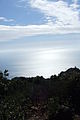
gallery

In the Esterel Mountains
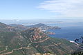
View of the bay of Cannes

Rocher Saint Barthelemy

Way to Rocher Saint Barthelemy

Way to Rocher Saint Barthelemy
View of the bay of St. Tropez


Web links
Individual evidence
- ↑ Vestiges Ligure sur l'Auriasque
- ^ Vestiges Ligures au Bonnet du Capelan
- ↑ Écomusée du pays de la Roudoule, La Route des Grandes Alpes , Édition de l'écomusée du pays de la Roudoule, Puget-Rostang ISSN 1246-1938 , p. 23
- ↑ Archive link ( Memento of the original dated September 6, 2017 in the Internet Archive ) Info: The archive link was inserted automatically and has not yet been checked. Please check the original and archive link according to the instructions and then remove this notice.
- ↑ http://www.cotedazur.de/ausflugstipps/86-massif-de-lesterel.html