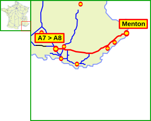
Autoroute A 8
| Autoroute A8 in France | ||||||||||||||||||||||||||||||||||||||||||||||||||||||||||||||||||||||||||||||||||||||||||||||||||||||||||||||||||||||||||||

|
||||||||||||||||||||||||||||||||||||||||||||||||||||||||||||||||||||||||||||||||||||||||||||||||||||||||||||||||||||||||||||
| |
||||||||||||||||||||||||||||||||||||||||||||||||||||||||||||||||||||||||||||||||||||||||||||||||||||||||||||||||||||||||||||
| map | ||||||||||||||||||||||||||||||||||||||||||||||||||||||||||||||||||||||||||||||||||||||||||||||||||||||||||||||||||||||||||||
| Basic data | ||||||||||||||||||||||||||||||||||||||||||||||||||||||||||||||||||||||||||||||||||||||||||||||||||||||||||||||||||||||||||||
| Operator: | ASF | |||||||||||||||||||||||||||||||||||||||||||||||||||||||||||||||||||||||||||||||||||||||||||||||||||||||||||||||||||||||||||
| further operator: | ESCOTA | |||||||||||||||||||||||||||||||||||||||||||||||||||||||||||||||||||||||||||||||||||||||||||||||||||||||||||||||||||||||||||
| Overall length: | 224 km | |||||||||||||||||||||||||||||||||||||||||||||||||||||||||||||||||||||||||||||||||||||||||||||||||||||||||||||||||||||||||||
|
Regions : |
||||||||||||||||||||||||||||||||||||||||||||||||||||||||||||||||||||||||||||||||||||||||||||||||||||||||||||||||||||||||||||
| The A 8 near Nice-Saint Augustin | ||||||||||||||||||||||||||||||||||||||||||||||||||||||||||||||||||||||||||||||||||||||||||||||||||||||||||||||||||||||||||||
|
Course of the road
|
||||||||||||||||||||||||||||||||||||||||||||||||||||||||||||||||||||||||||||||||||||||||||||||||||||||||||||||||||||||||||||
The Autoroute A 8 , also known as La Provençale , runs in Provence ; it connects Aix-en-Provence with Menton and east of it with the Italian A 10 on the Riviera and is part of the network of the Esterel-Côte d'Azur (ESCOTA) motorway company. It has a total length of 224 km.
General
The A 8 begins at the junction with the A 7 in the west of Aix-en-Provence. It is part of the European route 80 , which leads from Portugal to Iran . In the Bouches-du-Rhône , Var and Alpes-Maritimes departments , it connects the cities of Aix-en-Provence, Fréjus , Saint-Raphaël , Cannes , Antibes , Nice , Monaco and Menton with the French before crossing the A 10 in Italy and international highway network. It crosses the mountains of the Massif de la Sainte-Baume and the Massif des Maures between Aix-en-Provence and Fréjus and the Esterel between Cannes and Saint-Raphaël. From this motorway you have a comprehensive view over the Mediterranean between Nice and Menton.
history
- In 1956 ESCOTA was founded to build and maintain the entire line between Aix-en-Provence and the Italian border.
- In 1961 the toll sections Frejus - Mandelieu-la-Napoule and then on to Cagnes-sur-Mer near Nice were opened.
- 1969 saw the opening of the section between the toll station at Roquebrune-Cap-Martin and the Italian border (with a connection to the Italian motorway network). Initially, only one lane was open and trucks were not allowed to drive on it. Trucks were only able to use this area in the following year after both lanes were cleared.
State of development
- 2 x 3 lanes Coudoux (branch from the A 7), in La Barque (A branch of 52) and then from Saint-Maximin-la-Sainte-Baume at
- 2 × 3 lanes to Cagnes-sur-Mer
- 2 × 4 lanes from Cagnes-sur-Mer to Saint-Laurent-du-Var (exit to the city of Nice)
- 2 × 2 lanes between exits 50 (Nizza-Promenade des Anglais) and 51 (Nizza-Saint-Augustin)
- 2 × 2 or 3 lanes when crossing the southern foothills of the Alps from Nice to the Italian border. There are 15 tunnels on this route. The maximum speed is 110 km / h, 90 km / h in the tunnels (70 km / h for trucks).
Web links
- Autoroute A 8 in German and French version of the SARATLAS
- Autoroute A 8 on WikiSara (French)


