
Friedensdorf (Dautphetal)
|
Peace Village
community Dautphetal
|
|
|---|---|
.svg) |
|
| Height : | 268 (248-473) m above sea level NHN |
| Area : | 6.25 km² |
| Residents : | 1374 (December 31, 2017) |
| Population density : | 220 inhabitants / km² |
| Incorporation : | July 1, 1974 |
| Postal code : | 35232 |
| Area code : | 06466 |
 Location of Friedensdorf in Dautphetal
|
|
 Aerial view of Friedensdorf
|
|
Friedensdorf is a district of the municipality of Dautphetal in the central Hessian district of Marburg-Biedenkopf .
geography
location

Friedensdorf is located in the northern part of the municipality, about twelve kilometers west of Marburg . The place forms with the districts Dautphe , Wilhelmshütte and Wolfgruben the center of the large community of Dautphetal .
Mountains and elevations
The highest point of the municipality is the 473 meter high pig's head in the south, the lowest is the Lahn near the melting mill at about 242 meters above sea level. The 452 meter high Hornberg joins in the southwest of the village , east of the Hornberg there is the 465 meter high Eichelhardt. Between these two mountains lies the Homberg, which is about 390 meters high. In the west of the village rises the 306 m high hill Auf der Breitenlohe , on the south side of which is the New Cemetery. There is a war memorial at the summit of this Hornberg offshoot.
Rivers, streams and bodies of water
The Dautphe flows through the village and flows into the Lahn in the northwest of the village between the Ortmühle and the Schmelzmühle . A brook comes from the Roßberg from the south and flows into the Dautphe. In the Winterbach parcel, the Winterbach of the same name also flows from the Eckeberg in the direction of Mornshausen into the Dautphe, it flows into the river at the central school.
geology
Most of the ground consists of weathered slate. There is an old basalt quarry on Eckeberg. Other types of rock are diabase, clay and greywacke. Minerals are mainly serpentine, lime and hematite (iron ore).
history
The place was first mentioned around 1220 as Fridehelmisdorph in a document from the Haina monastery .
The statistical-topographical-historical description of the Grand Duchy of Hesse reports on Reddighausen in 1830:
"Friedensdorf (L. Bez. Gladenbach) evangel. Branch village; is 2 1 ⁄ 2 St. from Gladenbach, has 51 houses and 316 inhabitants, who are Protestant except for 1 Catholic, then 3 grinding mills with which 2 oil mills are connected. A lot of wheat is grown in the area. The place appears in earlier times under the name Fredilnüstorf . Copper ore is said to have been dug here in 1615. "
1 July 1974 at the Peace Village was within the framework of administrative reform in Hesse with 11 other municipalities powerful state law to the new greater community Dautphetal together . Local districts were set up for all formerly independent municipalities .
Territorial history and administration
The following list gives an overview of the territories in which Friedensdorf was located and the administrative units to which it was subordinate:
- before 1567: Holy Roman Empire , Landgraviate of Hesse , Biedenkopf Office , Dautphe Court
- from 1567: Holy Roman Empire, Landgraviate of Hessen-Marburg , Biedenkopf Office, Dautphe Court
- 1604–1648: disputed between Hessen-Kassel and Hessen-Darmstadt ( Hessenkrieg )
- from 1604: Holy Roman Empire, Landgraviate of Hessen-Kassel, Biedenkopf office, Dautphe court
- from 1627: Holy Roman Empire, Landgraviate Hesse-Darmstadt , Upper Duchy of Hesse , Biedenkopf Office, Dautphe Court
- from 1806: Grand Duchy of Hesse , Upper Duchy of Hesse , Biedenkopf Office
- from 1815: German Confederation , Grand Duchy of Hesse, Province of Upper Hesse , Biedenkopf Office
- from 1821: German Confederation, Grand Duchy of Hesse, Province of Upper Hesse, District of Gladenbach (separation of justice ( District Court Gladenbach ) and administration)
- from 1832: German Confederation, Grand Duchy of Hesse, Province of Upper Hesse, Biedenkopf district
- from 1848: German Confederation, Grand Duchy of Hesse, Biedenkopf district
- from 1852: German Confederation, Grand Duchy of Hesse, Province of Upper Hesse, Biedenkopf district
- from 1867: North German Confederation , Kingdom of Prussia , Province of Hesse-Nassau , District of Wiesbaden , District of Biedenkopf (transitional hinterland district)
- from 1871: German Empire , Kingdom of Prussia, Province of Hesse-Nassau, District of Wiesbaden, District of Biedenkopf
- from 1918: German Empire, Free State of Prussia , Province of Hessen-Nassau, Administrative Region of Wiesbaden, District of Biedenkopf
- from 1932: German Reich, Free State of Prussia, Province of Hessen-Nassau, Administrative Region of Wiesbaden, District of Dillenburg
- from 1933: German Empire, Free State of Prussia, Province of Hessen-Nassau, Administrative Region of Wiesbaden, District of Biedenkopf
- from 1944: German Empire, Free State of Prussia, Nassau Province , Biedenkopf District
- from 1945: American occupation zone , Greater Hesse , Wiesbaden administrative district, Biedenkopf district
- from 1949: Federal Republic of Germany , State of Hesse , Wiesbaden district, Biedenkopf district
- from 1968: Federal Republic of Germany, State of Hesse, Darmstadt district, Biedenkopf district
- 1974: Federal Republic of Germany, Land Hessen, Kassel , Marburg-Biedenkopf
- On July 1, 1974, Friedensdorf was incorporated into the newly formed community of Dautphetal.
- from 1981: Federal Republic of Germany, State of Hesse, Gießen district, Marburg-Biedenkopf district
population
Population development
Source: Historical local dictionary
| • 1577: | 23 house seats |
| • 1630: | 28 house seats (3 three-horse, 4 two-horse, 11 single-horse farm workers, 10 one-time men ), 3 widows. |
| • 1677: | 1 suitor, 31 house grounds, 6 widows, 10 single persons |
| • 1742: | 52 households |
| • 1791: | 244 inhabitants |
| • 1800: | 257 inhabitants |
| • 1806: | 274 inhabitants, 45 houses |
| • 1829: | 316 inhabitants, 51 houses |
| Friedensdorf: Population from 1791 to 2017 | ||||
|---|---|---|---|---|
| year | Residents | |||
| 1791 | 244 | |||
| 1830 | 316 | |||
| 1834 | 310 | |||
| 1840 | 318 | |||
| 1846 | 354 | |||
| 1852 | 371 | |||
| 1858 | 391 | |||
| 1864 | 434 | |||
| 1871 | 407 | |||
| 1875 | 422 | |||
| 1885 | 458 | |||
| 1895 | 471 | |||
| 1905 | 550 | |||
| 1910 | 616 | |||
| 1925 | 719 | |||
| 1939 | 787 | |||
| 1946 | 1,139 | |||
| 1950 | 1,168 | |||
| 1956 | 1,154 | |||
| 1961 | 1,209 | |||
| 1967 | 1,305 | |||
| 1980 | ? | |||
| 1990 | ? | |||
| 2000 | ? | |||
| 2007 | 1,427 | |||
| 2011 | 1,377 | |||
| 2016 | 1,367 | |||
| 2017 | 1,374 | |||
| Data source: Historical municipality register for Hesse: The population of the municipalities from 1834 to 1967. Wiesbaden: Hessisches Statistisches Landesamt, 1968. Further sources:; 1791 :; after 2000: Dautphetal community ( web archive ); 2011 census | ||||
Religious affiliation
Source: Historical local dictionary
| • 1829: | 315 Protestant, 1 Roman Catholic resident |
| • 1885: | 455 Protestant, no Catholic, 3 other Christians |
| • 1961: | 1090 Protestant (= 90.16%), 116 Roman Catholic (= 9.59%) inhabitants |
Gainful employment
Source: Historical local dictionary
| • 1867: | Labor force: 78 agriculture, 10 mining and metallurgy, 1 education and teaching, 1 community administration. |
| • 1961: | Labor force: 141 agriculture and forestry, 331 manufacturing, 53 trade and transport, 58 services and other. |
politics
Local advisory board
The local advisory board is headed by Mayor Rolli Messerschmidt (BLF). His deputy is Heidrun Bamberger (BLF).
coat of arms
Blazon : Above a red, scaled shield base with a black roof ridge, a flying silver dove with a green branch in its beak.
Culture and sights
- Local museum
- War memorial near the cemetery
- Old Protestant church (rebuilt by church builder Ludwig Hofmann )
- Old graveyard
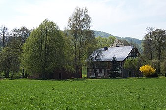
Ortmühle

Neumühle

Smelting mill

Old church


_1.jpg)
Economy and Infrastructure
traffic
The Friedensdorf (Lahn) train station is on the Kreuztal – Cölbe railway line . Trains of the Kurhessenbahn run here . Furthermore, Friedensdorf is on the Lahn valley cycle path . The regional bus route 481, the local bus routes MR-51, MR-52, the school bus routes 41, 53 and 57 as well as the dial-a-ride buses AST 50 and 51 drive to the place. The village is on Landstrasse 3042 (Lahnstrasse), which connects federal roads 62 and 453 .
Freetime activities
- sports ground
- Children's playgrounds
- Indoor swimming pool in the community center
Public facilities
With the Dautphetalschule, the district has a central school with the branches of elementary, secondary and secondary school and the Burgbergschule, a school for learning and educational assistance. In the immediate vicinity of these schools there is a multi-purpose hall, the Hinterlandhalle . In addition to being used as a sports hall for school sports and community clubs, larger events such as trade fairs and lectures take place here on a regular basis. Further facilities are the community center, an indoor swimming pool, a kindergarten, the new Protestant church, cemetery and a local museum.

Substation


literature
- Heimat- und Beautification Association Friedensdorf e. V. (Ed.): Chronicle Friedensdorf . Dautphetal 2002
- Literature about Friedensdorf in the Hessian Bibliography
Web links
- Friedensdorf district on the website of the municipality of Dautphetal.
- Friedensdorf, Marburg-Biedenkopf district. Historical local dictionary for Hessen. In: Landesgeschichtliches Informationssystem Hessen (LAGIS).
Individual evidence
- ↑ a b c d e f g Friedensdorf, Marburg-Biedenkopf district. Historical local dictionary for Hessen. (As of October 16, 2018). In: Landesgeschichtliches Informationssystem Hessen (LAGIS).
- ↑ "Population figures of the municipality of Dautphetal" on the website of the municipality of Dautphetal, accessed on March 28, 2018
- ^ A b Georg Wilhelm Justin Wagner : Statistical-topographical-historical description of the Grand Duchy of Hesse: Province of Upper Hesse . tape 3 . Carl Wilhelm Leske, Darmstadt August 1830, OCLC 312528126 , p. 78 ( online at google books ).
- ↑ Law on the reorganization of the Biedenkopf and Marburg districts and the city of Marburg (Lahn) (GVBl. II 330-27) of March 12, 1974 . In: The Hessian Minister of the Interior (ed.): Law and Ordinance Gazette for the State of Hesse . 1974 No. 9 , p. 154 , § 20 ( online at the information system of the Hessian state parliament [PDF; 3.0 MB ]).
- ^ Federal Statistical Office (ed.): Historical municipality directory for the Federal Republic of Germany. Name, border and key number changes in municipalities, counties and administrative districts from May 27, 1970 to December 31, 1982 . W. Kohlhammer, Stuttgart / Mainz 1983, ISBN 3-17-003263-1 , p. 350 f .
- ^ Michael Rademacher: German administrative history from the unification of the empire in 1871 to the reunification in 1990. State of Hesse. (Online material for the dissertation, Osnabrück 2006).
- ^ Grand Ducal Central Office for State Statistics (ed.): Contributions to the statistics of the Grand Duchy of Hesse . tape 13 . G. Jonghause's Hofbuchhandlung, Darmstadt 1872, DNB 013163434 , OCLC 162730471 , p. 12 ff . ( Online at google books ).
- ↑ The affiliation of the Biedenkopf office based on maps from the Historical Atlas of Hessen : Hessen-Marburg 1567–1604 . , Hessen-Kassel and Hessen-Darmstadt 1604–1638 . and Hessen-Darmstadt 1567–1866 .
- ↑ Wilhelm von der Nahmer: Handbuch des Rheinischen Particular-Rechts: Development of the territorial and constitutional relations of the German states on both banks of the Rhine: from the first beginning of the French Revolution up to the most recent times . tape 3 . Sauerländer, Frankfurt am Main 1832, OCLC 165696316 , p. 7 ( online at google books ).
- ↑ a b Grand Ducal Central Office for State Statistics (ed.): Contributions to the statistics of the Grand Duchy of Hesse . tape 13 . G. Jonghause's Hofbuchhandlung, Darmstadt 1872, DNB 013163434 , OCLC 162730471 , p. 27 ff ., § 40 point 6d) ( online at google books ).
- ↑ a b Hessen-Darmstadt state and address calendar 1806 . In the publishing house of the Invaliden-Anstalt, Darmstadt 1806, p. 240 ( online in the HathiTrust digital library ).
- ↑ Latest countries and ethnology. A geographical reader for all stands. Kur-Hessen, Hessen-Darmstadt and the free cities. tape 22 . Weimar 1821, p. 415 ( online at Google Books ).
- ↑ a b Hessen-Darmstadt state and address calendar 1791 . In the publishing house of the Invaliden-Anstalt, Darmstadt 1791, p. 185 ( online in the HathiTrust digital library ).
- ↑ Hessen-Darmstadt state and address calendar 1800 . In the publishing house of the Invaliden-Anstalt, Darmstadt 1800, p. 197 ( online in the HathiTrust digital library ).
- ↑ Selected data on population and households on May 9, 2011 in the Hessian municipalities and parts of the municipality. (PDF; 1 MB) In: 2011 Census . Hessian State Statistical Office

Districts: Dautphe | Allendorf | Buchenau | Damshausen | Elmshausen | Friedensdorf | Herzhausen | Holzhausen | Hommertshausen | Mornshausen | Silberg | Wolf pits
Partial locations: Amelose | Carlshütte | Wilhelmshütte