
Buchenau (Dautphetal)
|
Buchenau
community Dautphetal
|
|
|---|---|
.svg) |
|
| Height : | 235 (235-471) m above sea level NHN |
| Area : | 12.09 km² |
| Residents : | 1853 (December 31, 2017) |
| Population density : | 153 inhabitants / km² |
| Incorporation : | July 1, 1974 |
| Postal code : | 35232 |
| Area code : | 06466 |
.png) Location of Buchenau in the municipality of Dautphetal
|
|
 Aerial view of Buchenau from the southwest
|
|
Buchenau ( Buchenau / Lahn ; Buchenau an der Lahn ) is a district of the large municipality of Dautphetal in the north-west of Central Hesse , about twelve kilometers west of Marburg, with around 1900 inhabitants . The Lahn , which flows through the place, the old village with the half-timbered houses and the church on the edge, as well as the development of the valley slopes with the prominent "high-rise buildings" characterize the place.
Until the merger with eleven other communities to form the community of Dautphetal in 1974, Buchenau was an independent community, to which, in addition to the Carlshütte industrial estate from 1972 to 1974, the Biedenkopfer district of Katzenbach also belonged. The place was first mentioned in 1238 in a document from the Caldern monastery . Therefore, the place celebrated its 777th anniversary in 2015.
geography

location
Buchenau is located on the eastern edge of the Rhenish Slate Mountains in the narrow upper Lahn valley in a basin , surrounded by the bagpipe foreheads Vorderstöffel (366 m), Ellenberg (438 m) and Bundeberg (385 m). To the east of the village and the Bundeberg, separated by the cut of the Lauterbach, is the 460 meter high Homberg with the Homberg near Buchenau nature reserve, the eastern half of which is already within the boundaries of the neighboring municipality of Lahntal .
The old town center is about 240 m above sea level. NN and includes the Alte Landstrasse, Gassenweg, Hollergasse, Grabenstrasse and Bachstrasse. In the clustered village there are mainly three-sided and hook yards. Over time, the development on the valley slopes has expanded to the edge of the forest.
The highest point of the Buchenau district is on the Salzköpf at almost 500 m above sea level. NN on the north-eastern boundary, the lowest with less than 235 meters in the east on the Lahn on the boundary and municipality.

Neighboring communities
The neighboring towns are the districts of Treisbach and Warzenbach of the city of Wetter , clockwise from the north , the district of Brungershausen of the municipality of Lahntal in the east, the Dautphetal districts of Elmshausen , Allendorf and Friedensdorf in the southeast to southwest , and the Biedenköpfer districts of Kombach and Katzenbach to the west and northwest .
Embedded between the federal highway 62 and the railway line of the Upper Lahn Valley Railway, in the western area of the Buchenau district and southeast of the locality, there is a section of the landscape protection area Auenverbund Lahn-Ohm with a total size of around 5915 hectares. The objectives of the protection are "[...] the preservation and development of the typical character of the Lahn and Ohm valley floodplains with their tributaries in their functions as a habitat for animal and plant species typical of the floodplain and their communities, as a floodplain and as a recreational area, and because of their importance for the local climate . “To the east of the village in the area of the eponymous mountain lies the Homberg near Buchenau nature reserve with a size of around 33.7 hectares.
geology


The landscape around Buchenau lies at the extreme eastern edge of the Rhenish Slate Mountains and is characterized by rocks that were deposited in a sea during the Devonian and Carboniferous . For a long time, the sea coast was roughly where the northern edge of the Slate Mountains is today, i.e. in the Düsseldorf, Wuppertal and Brilon area. During the Variscan mountain formation at the end of the Carboniferous, the deposits were folded and crossed by numerous faults . The resulting mountains were removed again in the Permian and formed a little indented hilly country, which at the time when shallow seas covered parts of today's Germany, was only flooded at the edge. Since the end of the Tertiary , the slate mountains were raised again so that streams and rivers could cut their way and the present-day landscape was formed.
Geological classification
After the slate mountains have been divided into large structures, Buchenau is located at the eastern end of the Dillmulde immediately north of the Hörre zone. The large unit of the Dillmulde is a synclinory and is divided into several sub-units, which stretch as elongated, but only a few kilometers wide folds or tectonic scales in a southwest-northeast direction from the Westerwald to the edge of the slate mountains. A distinction is made in the Buchenau area from northwest to southeast:
- the Kombacher Mulde
- the Eisemröther Scale, on its north-west side of the Eisemröther thrust thrust over the trough Kombacher
- the Endbacher Schuppe, pushed over onto the Eisemröther Schuppe on its northwest side at the Endbacher thrust
The collapse of the stratification is directed towards the southeast, with only a few and mostly small-scale exceptions. The thrusts also dip to the southeast. The rocks are the more or less according to their hardness geschiefert , the hard rocks are generally perpendicular to the bedding fractured .
rocks
The gray wacky and slate of the Kombacher Mulde come from the carbon and build up the heights of the Hirschstein and the Stöffels. Via Mornshausen and the Lahnknie north of Friedensdorf, the Eisemröther thrust reaches the area around Buchenau and runs along the east side of Hirschstein and Stöffel. It cannot be observed directly in the area, at most the deviating rocks of the Eisemröther Schuppe southeast of it reveal its location. It is about Wissenbach slate , sandstone and limestone of the Upper Devonian , into which numerous diabase have penetrated in the Lower Carboniferous . These rocks form the underground of Buchenau and extend to the southeast to the Hauwald. The Endbach thrust reaches the Lahn valley from the southwest near Elmshausen, but is no longer open on its north side. The Endbacher Schuppe bordered by it builds up the heights south of Elmshausen and consists of clay slate and sandstones from the Middle Devonian . All these geological units are densely forested due to the poor soils.
Mudstones , sandstones, and subordinate conglomerates and dolomites of the Zechstein form the open landscape around Warzenbach and north of it. The most recent rock formations around Buchenau are the river deposits of the Lahn ( loose rock such as gravel , sand , alluvial clay ).
Waters
Buchenau has always had abundant water sources and plentifully usable groundwater. In earlier times the inhabitants took the water from wells that had been dug in the vicinity of the place. The streams flowing through the village were also used as cattle troughs. The Lahn , into which a large number of smaller streams and ditches in the local area of Buchenau flow, is the largest body of water in the district from west to east. On the left, the Katzenbachtal opens from the northwest, which leads the eponymous brook to the Lahn. The Ellenbach comes from the Ellenberg into the village, is piped there and flows along the Bachstraße and the Alte Landstraße into the so-called Mühlgraben as well as the Goldbach and the Seelbach. The Allbach and the Hüttengraben of the Carlshütte in the west of the district flow orographically on the right side near the hut, the Lauterbach flows into the Lahn in the east of the district on the left near the Lahneck house.
climate
Buchenau lies in the warm, temperate rainy climate of the middle latitudes. The daily mean temperature is 16 to 17 ° C in summer and around −1 to 1 ° C in winter. The mean amount of precipitation in the Buchenau area is around 700 to 800 millimeters.
|
Average monthly temperatures for
Source:
|
history
Early history
The first signs of human activity in the Buchenau district go back to the Neolithic . Many vessel remains, flint shavings , arrowheads as well as stone axes and other Stone Age objects have already been found, which at least point to settlements from this time in the area. The ring wall at Rimberg , about four kilometers south of Buchenau, is dated from the late Hallstatt period to the Latène period . Roman coins of Emperor Valerian (253–260) were found in the neighboring Elmshausen district .
Middle Ages and Modern Times
Buchenau was first mentioned in a document in 1238 in a document from the Caldern monastery. Before that, with the death of Count Giso IV , the Zent Dautphe came to the Ludowingers and thus to the Landgraviate of Thuringia. After the last male heir died there, the Thuringian-Hessian War of Succession broke out , in which Sophie von Brabant was able to secure the Hessian possessions for her son Heinrich against the Archdiocese of Mainz , which also made territorial claims, in the Landgraviate of Hesse . A noble family from Buchenau / de Bokenowe was mentioned several times between 1210 and 1575.
In 1567 Buchenau fell to the Landgraviate of Hessen-Marburg under Ludwig IV, after Landgrave Philip I (The Magnanimous) had died. 1604 fell with Hessen-Marburg Buchenau to Moritz the scholar of Hessen-Kassel , who introduced the Reformed Calvinist creed. 20 years later, Hesse-Marburg went to Ludwig V, the faithful , of Hesse-Darmstadt and after the religious conflict in the Thirty Years' War, after disputes about inheritance . At the end of the war in 1649 Buchenau and the hinterland fell to Hesse-Darmstadt, the neighboring towns of Warzenbach and Brungershausen , as well as Marburg, came to Hesse-Kassel. 16 years later, the first documented border inspection took place in Buchenau .


During the Seven Years' War (1756–1763) both French and Prussian troops moved through the hinterland . Both left behind some major damage, especially the year 1761 was bad for the Buchenau. From mid-February the French troops occupied the region and tore down all existing bridges over the Lahn. At the same time, the residents' supplies were confiscated. In addition, a hailstorm in August destroyed a large part of the harvest, so that the occupying troops themselves covered the thatch on the roofs to feed the horses. In 1763 the opposing troops faced each other near Buchenau. The Prussian General Luckner occupied the forest between Buchenau and Brungershausen with his hussars and Brunswick hunters . He himself had his quarters in the neighboring Warzenbach . The positions of the French with the Freicorps Dauphiné and the Grenadiers de France and du Roi extended from the castle to the Roßberg in Elmshausen . After an attack by the French on November 7th on Luckner's post in Buchenau, Luckner launched a counterattack, which ended successfully, which ultimately led to the end of the conflict at this point. Today there is a commemorative plaque by the spring named after Count Luckner in neighboring Brungershausen.
The statistical-topographical-historical description of the Grand Duchy of Hesse reports on Buchenau in 1830:
"Buchenau (L. Bez. Battenberg) evangel. Parish village; is located in a valley on both sides of a stream close to the Lahn, such as at the leading of Biedenkopf to Marburg Chaussee, and 4 1 / 2 St. Battenberg. The place has 72 houses and 456 evangelists. Inhabitants, 1 church, 2 grinding mills with 2 oil mills and a border customs office 1st class. In the district there is a limestone quarry, the stones of which are mostly used on the Ludwigshütte for the river of iron stones. The area also has iron stones, which were used earlier, just as mercury was once mined. Philipp von Dorring, who died in Elmshausen in 1563, is buried in the church. In addition to this tomb, there are four other tombs that were set for Alexander von Döring, the court master of Landgrave Ludwig IV of Marburg, and his wife and children. - In the 12th century Buchenau belonged to Ludwig I, Landgrave of Thuringia and Lord of Hesse, and later to his successors. After the death of Heinrich Raspe IV in 1247, the place came under the sovereignty of Heinrich I. This first Landgrave of Hesse brought the knighthood outraged against him in his country to obedience, and at this opportunity destroyed the two fortress castles in the area Knight of Hohenfels, which happened around 1293. In 1347 the plague raged in Buchenau. In 1370 the parish and the church donated a part of his court to Hartenrod from the knight Kraft von Buchenau. According to the legend, these knights lived in front of the village on the so-called castle. From Döring's documents we know that these knights exchanged certain inclines and interest rates at Buchenau for the Lords of Döring (who owned the village of Elmshausen to the east until 1791). Buchenau came to Landgrave Hermann in 1458, lastly Archbishop of Cölln and son of Landgrave Ludwig I, and in 1562 Landgrave Ludwig IV of Marburg received it, and after his death passed it on to his son, Landgrave Moriz von Cassel, until 1623 the place came to Hessen Darmstadt. During the Thirty Years' War the inhabitants had to flee, and Buchenau was enlarged by the nearby town of Appenhausen, whose inhabitants put their few spared houses here. During the Seven Years' War, Buchenau suffered tremendously from billeting, marching through, and looting, and the damage inflicted by the armies on both sides amounted to 73.663 florins according to the judicial estimate . The choir of the church, according to an existing inscription, is said to be 1090 of Heil. Pamphilina have been consecrated. The von Weitershausen and von Döring shared the right to present the preachers in Buchenau, and afterwards left it to the latter alone. A nunnery is said to have stood here, and it was closed during the Reformation. "
_in_germany.jpg)
.jpg)
Friedrich Carl Klein founded the Carlshütte in 1844 and heralded industrialization in Buchenau. The residents, who were mainly active in agriculture, had already earned extra income by removing ores and rocks (on mining in the region: → main article Lahn-Dill area ). When the Carlshütte was built, many people found work there. As a result, the welfare of the community was linked to that of the company. In 1883 the railway line from Cölbe to Biedenkopf was put into operation, which, together with the construction of further traffic routes (from 1848), also created work for many people. The rest of the infrastructure also fell in the transition from the 19th to the 20th century. The central water supply network was put into operation in 1908 after the new school had been built in 1890 and the town hall in 1905. Electric light first appeared on December 24, 1920.
First World War to the end of the Second World War
At the beginning of the First World War (1914-1918) there was no great enthusiasm for war in Buchenau, which changed with the first victories in East and West. In November 1914, refugees from Russian-occupied border areas were quartered in the village for about a month. In the further years of the war, children from cities were repeatedly accommodated in Buchenau, as the supply situation there did not seem quite so catastrophic. Towards the end of the First World War, the supply situation became increasingly difficult. Due to the labor shortage, so-called school columns were deployed to help the farmers with the harvest. Despite food rationing and the economy in shortages , the situation remained calm. A total of 23 Buchenau were killed in World War I, six went missing.
In the period that followed, residents suffered from ongoing inflation , which peaked in 1923. With the introduction of the Rentenmark all savings became practically worthless, only real estate and real estate retained their value. The community's own savings and loan fund only had 21 marks. The circumstances led to an unprecedented level of unemployment, due to the shutdown of the Carlshütte with over 120 employees. As a result, the situation recovered, so that the Carlshütte employed around 440 people again in 1929. The unusually severe winter of 1928/1929 brought the community temperatures down to −33 ° C. The Lahn and the streams flowing towards it were almost completely frozen and almost all the water pipes were frozen. The last water pipes only thawed again at the end of April 1929.
The global economic crisis hit Carlshütte and with it Buchenau, which at that time had around 1000 inhabitants. At times the business was completely idle and the people in the village could barely support their families. In addition, there were differences between part of the population and the incumbent left-wing mayor Göcking, so that the NSDAP was able to record 409 of the 604 votes cast in the Reichstag election by 1932 . The local history researcher Anneliese Westmeier wrote in this context:
“(…) What is reported is a lesson in the careless handling of democratic freedom: the global economic crisis, high unemployment, reparations payments lead to economic hardship, and a freely elected democratic government can no longer master the situation. A majority of the citizens, repulsed by party quarrels, allow themselves to be seduced by false prophets, help them to gain power, are satisfied with an initial improvement in material conditions, see too late or do not want to see that the people are incapacitated and that power takes precedence. Then it will be too late and in the end there will be a terrible collapse with death and ruin. "
The dissolution of the Biedenkopf district and its incorporation into the Dillenburg district triggered further resentment in the summer of the same year . After the seizure of power in 1933, Hermann Göring drove through the town on the occasion of the introduction of the new High President of Hessen-Nassau, Philipp von Hessen . The citizens of Buchenau used this to welcome Göring to the Biedenkopf district, although it no longer existed. The thoroughfare was renamed from Neue Landstrasse to Strasse der SA. Towards the end of the year, the Biedenkopf district was reduced in size by some places and restored. Unemployment was almost eliminated after the seizure of power, as many workers were employed on the construction of the Reichsautobahn Frankfurt am Main - Gießen - Kassel or on district roads. In 1936 the Buchenau ironworks was founded near the train station, which made it possible to somewhat reduce the town's dependence on the Carlshütte as the only industrial company. In 1941 the Protestant school was closed and converted into a community school. During this time the last student took off her costume .
Buchenau experienced the first bombardment by enemy aircraft on December 12, 1941, when a fighter bomber bombarded the station . A train driver died of his injuries. In the following period there were repeated enemy air raids. On February 28, 1945 the Carlshütte was bombed and three people were killed and three people were wounded. A month later the Volkssturm was dispatched to intercept enemy tanks. After 18 rifles were distributed to the 90-person group, the local group leader and the mayor Muth went ahead to encourage the group. The march did not take very long, however, because fleeing troops came towards them on the road to Allendorf. Towards the afternoon the district leader of the NSDAP , Wilhelm Thiele , and district administrator Dr. Burghof to Buchenau to send the Volkssturm off again and to confiscate the last reserves of the petrol station in Buchenau. It later emerged that the political staff had tried to escape using this gasoline.
When the American forces reached Buchenau on March 29, 1945 at 5:45 a.m. , white flags were hanging in the windows. The military convoy was so long that American military vehicles passed the town without interruption until noon, and this continued in a more moderate way until 5pm. Most residents of the village looked at the American troops for the first time a black , causing some fear, as they have a "bogeyman" only in connection with the Grenzgang knew. The soldiers took up quarters in the village for eleven months.
Development since

Immediately after the war, many refugees were taken in Buchenau, which led to a major housing shortage. As a result, large building areas were designated and a new school was built on Johannesstrasse in 1952. Other cost-intensive measures in the post-war years included flood regulation by paving a newly created Lahn bed and the construction of weirs and a flood protection wall on the northern bank after a devastating flood in the winter of 1946. In addition, the town was canalized in the 1950s and the first was built Wastewater treatment plant in the Biedenkopf district and the paving of the roads that were almost without exception unpaved. As a result of the economic boom, the number of inhabitants continued to rise due to improved living conditions and immigration, which is why the high-rise buildings in Uhlenhorst, now referred to as urban development deficiencies, were built during this period.
Katzenbach was incorporated on December 31, 1971. On July 1, 1974, Buchenau was merged with 11 other municipalities to form the new municipality of Dautphetal as part of the regional reform in Hesse . The district Katzenbach was assigned to the city of Biedenkopf.
In 1984 a flood of the century caused great damage. Among other things, operations on the Oberen Lahntalbahn had to be stopped for a short time because the track bed had been washed away.
Territorial history and administration
The following list gives an overview of the territories in which Buchenau was located and the administrative units to which it was subordinate:
- before 1567: Holy Roman Empire , Landgraviate of Hesse , Biedenkopf Office , Dautphe Court
- from 1567: Holy Roman Empire, Landgraviate Hessen-Marburg , Amt Biedenkopf
- 1604–1648: disputed between Hessen-Kassel and Hessen-Darmstadt ( Hessenkrieg )
- from 1604: Holy Roman Empire, Landgraviate Hessen-Kassel, Biedenkopf office
- from 1637: Holy Roman Empire, Landgraviate Hesse-Darmstadt , Upper Duchy of Hesse , Biedenkopf Office
- from 1806: Grand Duchy of Hesse , Upper Duchy of Hesse , Biedenkopf Office
- from 1815: German Confederation , Grand Duchy of Hesse, Province of Upper Hesse , Biedenkopf Office
- from 1821: German Confederation, Grand Duchy of Hesse, Province of Upper Hesse, District Battenberg (separation of justice ( district court Biedenkopf ) and administration)
- from 1832: German Confederation, Grand Duchy of Hesse, Province of Upper Hesse, Biedenkopf district
- from 1848: German Confederation, Grand Duchy of Hesse, Biedenkopf district
- from 1852: German Confederation, Grand Duchy of Hesse, Province of Upper Hesse, Biedenkopf district
- from 1867: North German Confederation , Kingdom of Prussia , Province of Hesse-Nassau , District of Wiesbaden , District of Biedenkopf (transitional hinterland district)
- from 1871: German Empire , Kingdom of Prussia, Province of Hesse-Nassau, District of Wiesbaden, District of Biedenkopf
- from 1918: German Empire, Free State of Prussia , Province of Hessen-Nassau, Administrative Region of Wiesbaden, District of Biedenkopf
- from 1932: German Reich, Free State of Prussia, Province of Hessen-Nassau, Administrative Region of Wiesbaden, District of Dillenburg
- from 1933: German Empire, Free State of Prussia, Province of Hessen-Nassau, Administrative Region of Wiesbaden, District of Biedenkopf
- from 1944: German Empire, Free State of Prussia, Nassau Province , Biedenkopf District
- from 1945: American occupation zone , Greater Hesse , Wiesbaden administrative district, Biedenkopf district
- from 1949: Federal Republic of Germany , State of Hesse , Wiesbaden district, Biedenkopf district
- from 1968: Federal Republic of Germany, State of Hesse, Darmstadt district, Biedenkopf district
- 1974: Federal Republic of Germany, Land Hessen, Kassel , Marburg-Biedenkopf
- On July 1, 1974, Katzenbach was incorporated as a former district of Buchenau as a district of the municipality of Biedenkopf. At the same time, Buchenau was attached to the newly formed community of Dautphetal as a district.
- from 1981: Federal Republic of Germany, State of Hesse, Gießen district, Marburg-Biedenkopf district
population
Population development

The first data on the population of Buchenau are recorded for 1799. For 1577 the number of households was given as 58, which at best allows an approximate estimate of the population. By 1742 it rose to 78, in 1846 to 99 and in 1910 to 179 households. In 1950 it rose further to 392 and reached around 500 in 1970.
The population was given for 1799 including the Elmshausen farm as 356. In the following 100 years it almost doubled to 738 in 1900. Around 30 people lived in Carlshütte at that time. In 1910 the population reached 929 people. Due to the First World War, the population increased only slowly in the following years and reached the level of 1039 in 1939. After the end of the Second World War it rose by 50% to 1516 due to the admission of many evacuees and refugees . The number rose as a result of the economic boom once again. From the 1970s it was moving towards the 2000 mark. For about 20 years the population has been fluctuating between 1900 and 2000 (main residence only) with a slightly downward trend.
Population data before 1807:
Source: Historical local dictionary
| • 1577: | 56 house seats |
| • 1630: | 60 house seats (18 two-horse, 7 single-horse farm workers, 35 single-horse ), 6 widows. |
| • 1677: | 3 free, 51 house grounds, 6 widows, 32 single people |
| • 1742: | 78 households |
| • 1791: | 344 inhabitants |
| • 1806: | 375 inhabitants, 50 houses |

Religious affiliation
Source: Historical local dictionary
| • 1830: | 456 Protestant residents |
| • 1885: | 660 Protestant, 5 Catholic, 24 other Christians, 17 Jews. |
| • 1961: | 1377 Protestant, 164 Roman Catholic residents |
Gainful employment
Source: Historical local dictionary
| • 1867: | Labor force: 277 agriculture, 1 forestry, 44 mining and metallurgy, 25 trade and industry, 5 trade, 4 transport, 1 health care, 1 education and teaching, 1 church and worship, 4 community administration. |
| • 1961: | Labor force: 223 agriculture and forestry, 385 manufacturing, 65 trade and transport, 68 services and other. |
Appenhausen desert
The Appenhausen desert lies in the Buchenau district . The place was first mentioned in 1370. It was two kilometers west of Buchenau. It is not known exactly when the place became deserted; by the end of the 15th century it was no longer mentioned in relevant documents. According to the possessions, the residents of Appenhausen settled in the Grabenstrasse and Hollergasse in Buchenau. A fountain and a memorial stone in Grabenstrasse remind of the desert.
religion

The villages of Buchenau and Elmshausen belong to the Evangelical Lutheran parish of Buchenau. During the service in the church, the children's service takes place in the neighboring parish hall. In addition to the usual church celebrations, festivals such as the parish festival or the mission festival are celebrated several times a year. Affiliated to the parish is the Protestant kindergarten, which accepts a limited number of children from the age of two, as well as a crèche that is run together with the parish of Dautphetal.
Religious life in Buchenau has been shaped mainly by the Protestant church since the Reformation. In earlier times the Buchenau Church was probably a branch church in the parish of Dautphe. Dautphe was mentioned as Mark in 791 , later also as Zent . The first church patronage mentioned was owned by the von Linne family as a Nassau fief . From 1395 the von Dernbach family held this office, from 1477 it was the von Breidenbach, von Döring and von Weitershausen families. From 1492 only the von Döring family had patronage, which after their extinction went to the Ohm-Winter family via the von Breidenbach family together with the estate in Elmshausen and has been in their possession ever since.
The first known pastor was Eckhard von Hohenfels , mentioned in a document in 1295 ; the last Catholic pastor was Philipp Strack, who accepted the Lutheran creed in 1524. After the Hesse-Marburg line died out , the pastors in Upper Hesse had to accept the Reformed Confession due to the provisions of Landgrave Moritz the Scholar . As a result of the succession dispute, the Lutheran confession was reintroduced in 1624. Buchenau has been predominantly evangelical-Lutheran since the end of the Hessian War in 1648 and the division of Upper Hesse.
In contrast to neighboring towns such as Friedensdorf or Dautphe, Buchenau did not form its own free church community . However, the congregation is heavily involved in the missionary work of the Hermannsburg Mission and the Christian aid and mission organization DMG interpersonal and has various institutions such as a local association of the Blue Cross and the Sucht- und Lebenshilfe help-center e. V., which are rooted in the revival movements of the 19th and 20th centuries.
After the Second World War, many evacuees and refugees settled in Buchenau, so that a Catholic community was formed again. It is affiliated with the Catholic Church in Biedenkopf, but also uses the premises of the Protestant church.
Jews existed from the 18th century to the time of National Socialism. There was no separate Jewish community , the local Jews visited the synagogues in Wetter or Gladenbach. A Jewish cemetery was created in neighboring Elmshausen.
The followers of the Muslim faith visit the mosques in Biedenkopf, Marburg or Stadtallendorf.
politics
Local affiliation
Buchenau belonged to different noble families in the Middle Ages: the Landgraves of Hesse and the Counts of Nassau were just as wealthy as the families of the local nobility. These included the lords of Hohenfels , von Döring and von Buchenau .
In the 14th century, the Dautphe court, to which Buchenau belonged, was assigned to the Biedenkopf office . Since then Buchenau has belonged to this administrative structure, which has been changed several times in form and expansion; so the district of Biedenkopf became Prussian in 1866 in the administrative district of Wiesbaden in the province of Hessen-Nassau . In 1932 the Biedenkopf district was briefly dissolved and reduced in size again a year later. After the Second World War, the Biedenkopf district was merged with the city and district of Marburg in 1974 to form the new Marburg-Biedenkopf district and has belonged to the Central Hesse region since the Gießen district was formed in 1981.
Mayor and local council
Bernd Schmidt of the Free Voters ( FW ) has been mayor of the community of Dautphetal and thus also of the Buchenau district since 2004 . Since Buchenau was incorporated into Dautphetal in 1974, Buchenau has had a local advisory board with a local mayor. Andreas Feußner ( CDU ) has held this position since the local elections in 2006 . Heinrich Grebe was the last mayor of the independent municipality of Buchenau from 1967 to 1974.
The town council has been working for the municipal election in 2011 of three CDU members and two SPD members. He has an advisory role for the municipal council of Dautphetal with regard to the decisions of the committee that affect the Buchenau district. Some of the representatives of the local council are also community representatives.
coat of arms
|
|
Blazon : "In blue three golden sheaves (2: 1) under a golden shield head with a right red star."
This coat of arms, which has been in the mayor's office for a long time, was officially awarded to the community on December 20, 1952 as the community coat of arms by the Hessian Minister of the Interior. It is the coat of arms of the Lords of Buchenau , who lived in the 12th to 15th centuries south of the town on the other side of the Lahn on the so-called Buchenau Castle . The aristocratic family took their name from their ancestral home or headquarters in Buchenau. It already went out in the 16th century. At the same time, the sheaves are a suitable symbol of the village community in the upper Lahn valley. The old Hessen town had not yet had an image seal. |
Economy and Infrastructure
Agriculture and mining
Since the early Middle Ages cattle breeding and agriculture - since the peasant liberation in the 18th and 19th centuries. In the 19th century, due to the densely wooded municipal markings, logging was also used - the main source of income for the residents of Buchenau. The meadows and fields brought little income due to the poor soil, which is why many residents pursued a sideline: Some worked as workers in the surrounding quarries, while others drove the lime or charcoal to the surrounding ironworks. Still others worked as a harvest worker or day laborer and traveled to Wetterau, southern Hesse or Cologne to cut or thresh . The charcoal was then usual employment. With the advent of industrialization, more and more people worked in the Carlshütte, which was built in 1844, in mining or in iron smelting. The Carlshütte became more and more important for Buchenau, but also for the surrounding communities and employed more than 440 people in its heyday. The construction of Lahnstrasse in 1846 from Biedenkopf to Marburg (today's Bundesstrasse 62) and the Obere Lahntalbahn had a major impact on the employment structure. On the one hand, the construction work itself took up a lot of workers, on the other hand, it became easier to reach the steelworks and iron processing companies in the neighboring Siegerland.
Agriculture has been losing importance ever since industrialization. However, the size of the individual companies is steadily increasing. In 2008 there was only one full-time farmer with dairy farming and a farm size of over 100 hectares in Buchenau, as well as about a dozen part-time or hobby farmers who farm between one and 30 hectares. Most of them operate extensive agriculture with beef cattle or dairy farming.
Industry and Commerce
The development of industry in Buchenau, as in the entire Lahn-Dill area, is closely linked to the ore smelting of the local smelters. As early as the 18th century, the iron and manganese ores extracted in the Buchenau district were processed in simple furnaces built on site. From around 1780 the ores were sent to the Ludwigshütte for further processing in Biedenkopf . After the Carlshütte was built in the south-west of Buchenau in 1844, the owner at that time began processing the iron into various hardware items such as ovens, windows and pots in 1857, while ore smelting decreased. In 1908 the company was expanded to include an enamelling plant and a nickel-plating plant. After several bankruptcies and the associated changes of ownership, the company premises have been family-owned since the 1970s, and in 1976 their locksmith business moved there. Several companies that have rented various buildings are based on the site today.
The most important companies for Buchenau are the Pracht Group and Roth Industries . The Pracht company began as an electrical trade and switched to the manufacture of lights in the 1960s. At the beginning, the Roth company manufactured washing kettles and was thus mainly active in sheet metal and steel processing, before switching to plastics processing (sanitary and building technology, tank production) in Buchenau in the 1970s. The companies, some of which have more than 200 employees, are both located in the industrial area in the direction of Elmshausen , with the Pracht company having another location in the village, and the Roth company employing more than 1,100 people worldwide. Other companies with more than 15 employees are a plastics processing company, the gardening and landscaping company Balzer, and since 2013 a branch of the Allgäu packaging system manufacturer Multivac Sepp Haggenmüller (formerly a division of VC999, which sold it to Multivac). The Bernhardt fashion company, which manufactured high-quality men's suits, jackets, blazers and trousers, closed its doors in Buchenau at the beginning of 2017. In addition to commuting in the local area, the commuter relationship to the Rhine-Main area should be mentioned in particular .
In addition to the above-mentioned businesses, Buchenau is home to a large number of smaller trade and craft businesses. Since the age-related closure of three mom and pop shops, there are no longer any grocery stores in Buchenau, so that one has to switch to the shops in the surrounding larger towns (Dauthpe, Biedenkopf, Marburg). Due to this fact, some shops in the village, such as bakers, butchers or greengrocers, offer a selection of groceries and other everyday items in order to offer less mobile people a certain basic supply.
Infrastructure measures
In 1962 Buchenau was the first municipality in the Biedenkopf district in which the entire local area was canalized and connected to the municipality's own mechanical sewage treatment plant. The sewage treatment plant is operated by the Dautphetal sewage association and is designed for 15,000 PE (population equivalents) with the purification stages biological purification, nitrification , denitrification and phosphorus elimination . Until the central garbage disposal of the Biedenkopf district was set up, the community had a garbage dump. Waste disposal is now organized by the Biedenkopf waste disposal association.
As in many rural places, the availability of fast internet is very divergent. While the Roth company has fiber optic cables with a corresponding bandwidth, the bandwidth continues to decrease towards the northern edge of the village until it is completely absent. Cable TV and gas supply are not available.
In the health sector, the place has a doctor's practice and a dental practice as well as other health facilities such as a pharmacy, outpatient nursing service, a dental laboratory and a physiotherapy practice.
Public facilities
Since 1972 there has been a kindergarten in Buchenau sponsored by the Protestant parish. Up to 80 children are cared for in three mixed-age groups. One group takes in up to five children between the ages of two and three. The Rothkehlchen day nursery provides up to twelve places for children from under one year to three years.
The first reference to a school service in Buchenau is the mention of the sacrificial man Peter Bracht in the Salbuch of the Biedenkopf office , who performed the school service in addition to the bell ringer. There was no school building of its own. It was not until 1765 that a classroom was set up in the community brewery. About 40 children were being taught at that time. Between 1808 and 1833 up to 110 children were taught, and the children from Elmshausen were also educated here. In 1837 Buchenau's first school building at Neue Landstrasse 18, today the Breidenstein / Bernhard company, was inaugurated. The number of school children increased to 161 by 1883. Since the school building was too small, a room in a private house at the western end of Buchenau was rented as a school hall. In 1887 the existing school building was demolished again and in the same year a larger building with two classrooms and two teacher's apartments was built in the same place. As the school soon became too small again due to the growth of the town, a room in the deaconess house had to be rented in 1889. In 1920 the number of pupils was 221. In 1952 a new school building was built in Schulstrasse (today Johannesstrasse), named after the honorary mayor Andreas Grebe. In 1963 the Buchenau Vor der Hardt center school was built, to which a sports hall and a sports field were attached from 1970. The school consisted of a primary and a secondary school. After the abolition of the main school branch, a support level was set up. The Andreas Grebe School was demolished at the beginning of the new millennium. Today the school in Buchenau is purely a primary school. The Dautphetalschule in Friedensdorf is usually responsible for the secondary and secondary schools, the Lahntalschule in Biedenkopf or the municipal grammar school in Bad Laasphe for the secondary school.
With the construction of the community center in 1973, a building complex was built in Buchenau in Rothenbergstrasse, which includes an indoor swimming pool in addition to the fire brigade buildings, a restaurant with an attached bowling alley. The 10 m wide and 20 m long swimming pool with the 5 × 5 m baby pool has been supported by a support association of the Buchenau citizens since 2006. Swimming lessons for the surrounding schools take place in the indoor pool.
The Buchenau volunteer fire brigade was founded in 1924. At the end of the Second World War, the association was dissolved and re-established on July 30, 1957. Since the merger of the twelve local communities in 1974 to form the community of Dautphetal, the fire brigade moved from Alte Landstrasse to Rothenbergstrasse in the 1973 building complex of the community center and swimming pool. In addition to the general fire service, the fire brigade was specially equipped for the hazardous goods sector . In 2008 the fire brigade comprised 36 active members in the operations department and 12 members in the youth fire brigade . In addition to a Löschgruppenfahrzeug a stand trolley -Nachschub on duty. This vehicle was replaced by a swap body vehicle in mid-2009 . In addition, the fire brigade has a team transport vehicle that was procured from association funds.
traffic

The federal highway 62 runs through Buchenau . The next motorway connections are in Dillenburg ( A 45 ), Gießen (A 45) and Homberg (Ohm) ( A 5 ).
Buchenau has a connection to the rail network with the Upper Lahn Valley Railway. Between 6 a.m. and 7 p.m. there are two-hour connections in the direction of Marburg and in the direction of Bad Laasphe via Biedenkopf with densities (hourly) during rush hour. There is also a regional connection in Buchenau with bus line 481 in the direction of Biedenkopf and Marburg as well as a local connection with bus line MR-57 to the community area. The bus routes are operated by Verkehrsgesellschaft Mittelhessen .
In addition to the Hessian long-distance cycle path R2 and the Lahntal cycle path, there is a multitude of cycle and hiking trails through the large forests in the region. Buchenau is connected to the Lahn-Dill-Bergland hiking park with the Lahn-Dill-Bergland trail, which opened in 2008, or an associated extra tour .
Culture and sights
Buildings
The center of Buchenau is a listed building because of its cultural and historical importance. Many of the half-timbered houses date from the 17th century with scratch plaster work, carved wood or so-called wild men , a special half-timbered construction.
The centrally located old town hall, built in 1905, houses a small local museum and the local library. In the museum, regional exhibits on household and kitchen topics from the 1920s to 1950s as well as the Hinterland costume are on display.
Martinskirche Buchenau
The Protestant church, also called Martinskirche, is over 750 years old. According to oral tradition, a stone in the church choir is said to bear the year 1090, but this has not yet been proven. A pleban is named for the year 1265 . The church is occupied with the patronage of Ursula of Cologne. The choir tower with the groin vault , probably from the 10th to 13th centuries, is dedicated to St. Pamphilos of Caesarea and contains a tracery window on the south side . The late Gothic nave has bilateral galleries on the northern and western sides with the representation of the twelve apostles on the parapets. The crucifix in the chancel is also late Gothic. On the south and north walls hang pictures of Philip the Magnanimous and Martin Luther . Between the stalls and the choir tower there are gravestones of the former patron saints of Döring on the side walls . The old steel bells , which had been installed in the First World War for the delivered bronze bells, were replaced by bronze bells again in 1984 and lined up in front of the old rectory as a souvenir. The pulpit dates from 1660 and was moved to the nave at the turn of the millennium to improve the view of the altar.
Carlshütte
The former Carlshütte ironworks is also a listed building. It was created in 1844 and was the most important employer in the former municipality until the 1950s. The magazine , a large four-story half-timbered building, is the most distinctive building. To the south of the building complex is the so-called villa, where the hut owner lived at the beginning of the 20th century.
- Views of the structures
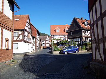
Half-timbered ensemble in the town center

Half-timbered house from 1632

Carlshütte magazine
_Fachwerk_1.jpg)


Borderline

Every seven years in Buchenau with the Grenzgang a folk festival takes place, at which the border of the place is migrated in two sections. This custom can be traced back to border disputes with the surrounding places, where border stones are often said to have been moved and thus valuable forest property was under discussion. The first border inspection is said to have taken place in 1665. Over time, a folk festival developed out of this, in which initially only the village population took part. More than 10,000 guests came later, making the Buchenau Grenzgang one of the largest folk festivals in the region. A border festival is documented for the first time for 1886, then until 1957 at irregular intervals. Since then it has taken place every seven years, next time in 2020.
dialect
In terms of language, Buchenau belongs to the West Central German language area . Until well into the 1950s, the Buchenauer Platt , the local dialect, was spoken almost without exception . Since then, the proportion of those who can still “talk flat” has been decreasing. Especially among young people, the dialect is increasingly being displaced by High German or the Regiolect of the South Hessian Rhine-Main area. The dialect is understood, but spoken less and less. In order to counteract this development, the Dialekt im Hinterland association was founded in 1998 . In cooperation with the Research Center Deutscher Sprachatlas , the project Documentation of the Hinterland Dialects was started, in which in 2005 the Buchenau dialect was comprehensively documented and recorded on CD .
Club life
As in the entire community of Dautphetal, the club life in Buchenau is very pronounced. The oldest club is the "Concordia" 1874 Buchenau choir. Originally founded as a men's choir, just as many women are represented there today. Other music associations are the Buchenau wind choir, the Buchenau mixed choir of the regional church community and the 1985 Buchenau minstrel. The oldest sports club is the Turnverein 1911 Buchenau with many departments such as handball, athletics, gymnastics and trampoline jumping. As early as the 1920s and 1930s, the soccer sports club 1921 Lahnlust Buchenau and the shooting club Buchenau were spun off and have been independent clubs ever since. Other sports clubs are the Dautphetal sports bowling association, the Buchenau cycling club, the Carlshütte tennis club and the DLRG local group Dautphe / Buchenau. Animal sports and breeding associations are the pigeon breeding association "Heimatliebe", the association of horse lovers and the association for German shepherds, local group Buchenau. In the cultural and local area there are, in addition to the painter's guild Kaleidoskop, the association for local history and the rural women's association, about a dozen other associations in the church and social area as well as so-called men's and women's societies and boys and girls, superordinate the border crossing association in connection with the Buchenau border crossing .
Personalities
- Albrecht Ohly (1829-1891), son of a Buchenau pastor, was the first full-time mayor of Darmstadt .
- Johannes Debus X. (1879–1966) was a member of the state assembly of Greater Hesse that advised the constitution, honorary mayor of Buchenau and holder of the Federal Cross of Merit on ribbon.
- Andreas Grebe (1899–?) Was Buchenau's first full-time mayor, honorary mayor and holder of the Federal Cross of Merit.
- Michael Evenari (Walter Schwarz) (1904–1989) was an important botanist. He grew up in the Jewish community of Buchenau / Elmshausen.
Sources and literature
- Ferdinand Luthmer : The architectural and art monuments of the districts of Biedenkopf, Dill, Oberwesterwald and Westerburg . Commission publisher by Heinrich Keller, Frankfurt 1910.
- Hans Feldtkeller : The architectural and art monuments of the Biedenkopf district: brief inventory . Eduard Roether Verlag, Darmstadt 1958.
- Karl Huth , district committee of the Biedenkopf district (ed.): Economic and social history of the Biedenkopf district 1800–1866 . Self-published, Biedenkopf 1962.
- Karl Huth, Buchenau / Lahn parish council (ed.): Buchenau. A walk through history and the present . Self-published, Buchenau / Lahn 1972.
- Peter Ihm : When were the Buchenauers with the Grand Duke? Church patronage and parish occupation in Buchenau, Biedenkopf office . Self-published, Dautphetal 1978.
- Peter Ihm, Jürgen Westmeier (ed.): Buchenau an der Lahn - history and stories in words and pictures . Self-published, Buchenau / Lahn 1985.
- Peter Ihm, Jürgen Westmeier (ed.): 750 years of Buchenau an der Lahn. Look into the past . Self-published, Buchenau an der Lahn 1988.
- Peter Ihm, Jürgen Westmeier (ed.): Buchenau an der Lahn - History and Stories: The Border Crosser 1992 . Self-published, Buchenau / Lahn 1992.
- Regional council Gießen (Ed.): Regionalplan Mittelhessen 2001 . Giessen 2001.
- Literature about Buchenau in the Hessian Bibliography
Web links
- Buchenau district on the website of the municipality of Dautphetal.
- Buchenau, Marburg-Biedenkopf district. Historical local dictionary for Hessen. In: Landesgeschichtliches Informationssystem Hessen (LAGIS).
Individual evidence
- ↑ a b c d e f g Buchenau, Marburg-Biedenkopf district. Historical local dictionary for Hessen. (As of March 23, 2018). In: Landesgeschichtliches Informationssystem Hessen (LAGIS).
- ↑ "Population figures of the municipality of Dautphetal" on the website of the municipality of Dautphetal, accessed on March 28, 2018
- ↑ a b c Data source: Dautphetal municipality
- ^ Sascha Valentin: Buchenau celebrates its 777th birthday. In: Hinterländer Anzeiger online. March 31, 2015, accessed October 17, 2017 .
- ↑ Background information on the project in the Marburg-Biedenkopf district (PDF; 724 KB)
- ↑ Environmental Atlas Hessen (accessed on November 11, 2013, data status: 2009, last update: 2010)
- ↑ Environmental Atlas Hesse . In: Hessian State Office for Environment and Geology 2005, [1. February 2006]
- ↑ averages at msn.com (accessed on 10 February 2016)
- ^ Association for Hessian History and Regional Studies : Communications to the members of the Association for Hessian History and Regional Studies , born in 1896, Kassel 1897, p. 46 ( digitized version )
- ^ Salbuch der Kirche (central archive of the Protestant Church in Hesse and Nassau, Darmstadt) in Karl Huth, Buchenau / Lahn parish council (ed.) 1972, p. 26f.
- ^ OP Marburg , October 4, 2007: Memorial plaque for a special person
- ^ Georg Wilhelm Justin Wagner : Statistical-topographical-historical description of the Grand Duchy of Hesse: Province of Upper Hesse . tape 3 . Carl Wilhelm Leske, Darmstadt August 1830, OCLC 312528126 , p. 37 f . ( Online at google books ).
- ↑ a b Buchenauer Schulchronik in: Peter Ihm, Jürgen Westmeier (Ed.) 1988, p. 23 ff.
- ↑ Anneliese Westmeier: From the Buchenau School Chronicle: Beginning and End of the Third Reich in: Peter Ihm, Jürgen Westmeier (Ed.) 1992, p. 33
- ↑ Anneliese Westmeier: From the Buchenau School Chronicle: Beginning and End of the Third Reich in: Peter Ihm, Jürgen Westmeier (Ed.) 1992, p. 33ff
- ↑ Law on the reorganization of the Biedenkopf and Marburg districts and the city of Marburg (Lahn) (GVBl. II 330-27) of March 12, 1974 . In: The Hessian Minister of the Interior (ed.): Law and Ordinance Gazette for the State of Hesse . 1974 No. 9 , p. 154 , § 20 ( online at the information system of the Hessian state parliament [PDF; 3.0 MB ]).
- ^ Federal Statistical Office (ed.): Historical municipality directory for the Federal Republic of Germany. Name, border and key number changes in municipalities, counties and administrative districts from May 27, 1970 to December 31, 1982 . W. Kohlhammer, Stuttgart / Mainz 1983, ISBN 3-17-003263-1 , p. 350 and 351 .
- ^ Michael Rademacher: German administrative history from the unification of the empire in 1871 to the reunification in 1990. State of Hesse. (Online material for the dissertation, Osnabrück 2006).
- ^ Grand Ducal Central Office for State Statistics (ed.): Contributions to the statistics of the Grand Duchy of Hesse . tape 13 . G. Jonghause's Hofbuchhandlung, Darmstadt 1872, DNB 013163434 , OCLC 162730471 , p. 12 ff . ( Online at google books ).
- ↑ Wilhelm von der Nahmer: Handbuch des Rheinischen Particular-Rechts: Development of the territorial and constitutional relations of the German states on both banks of the Rhine: from the first beginning of the French Revolution up to the most recent times . tape 3 . Sauerländer, Frankfurt am Main 1832, OCLC 165696316 , p. 7 ( online at google books ).
- ↑ a b Grand Ducal Central Office for State Statistics (ed.): Contributions to the statistics of the Grand Duchy of Hesse . tape 13 . G. Jonghause's Hofbuchhandlung, Darmstadt 1872, DNB 013163434 , OCLC 162730471 , p. 27 ff ., § 40 point 6d) ( online at google books ).
- ↑ Latest countries and ethnology. A geographical reader for all stands. Kur-Hessen, Hessen-Darmstadt and the free cities. tape 22 . Weimar 1821, p. 415 ( online at Google Books ).
- ↑ Historical municipality register for Hesse
- ↑ Hessen-Darmstadt state and address calendar 1791 . In the publishing house of the Invaliden-Anstalt, Darmstadt 1791, p. 185 ( online in the HathiTrust digital library ).
- ↑ Hessen-Darmstadt state and address calendar 1806 . In the publishing house of the Invaliden-Anstalt, Darmstadt 1806, p. 239 ( online in the HathiTrust digital library ).
- ↑ Appen Hausen, Marburg-Biedenkopf. Historical local dictionary for Hessen. (As of June 8, 2015). In: Landesgeschichtliches Informationssystem Hessen (LAGIS).
- ↑ a b Peter Ihm 1978.
- ↑ Buchenau school chronicle in: Peter Ihm, Jürgen Westmeier (Ed.) 1988, p. 9.
- ↑ a b c Homepage of the ev.-luth. Buchenau parish with Elmshausen
- ^ Renate Westmeier: On the history of the Jews in Buchenau and Elmshausen. In: Peter Ihm, Jürgen Westmeier (ed.): Buchenau an der Lahn - history and stories , Buchenau / Lahn 1992.
- ^ Karl Huth, Buchenau / Lahn parish council (ed.) 1972, p. 25.
- ↑ a b Municipality of Dautphetal → local politics → local advisory boards (accessed on November 4, 2013)
- ^ Karl Ernst Demandt , Otto Renkhoff : Hessisches Ortswappenbuch. C. A. Starke Verlag, Glücksburg / Ostsee 1956, p. 174.
- ↑ Approval for the use of a coat of arms for the municipality of Buchenau in the district of Biedenkopf, administrative district of Wiesbaden from December 10, 1952 . In: The Hessian Minister of the Interior (ed.): State Gazette for the State of Hesse. 1953 No. 2 , p. 11 , point 24 ( online at the information system of the Hessian state parliament [PDF; 4.0 MB ]).
- ↑ Schulchronik Buchenau in: Peter Ihm, Jürgen Westmeier (Ed.) 1988, p. 14ff.
- ^ Karl Huth, district committee of the Biedenkopf district (ed.) 1962.
- ↑ Peter Ihm, Jürgen Westmeier (Ed.) 1985, p. 26 ff.
- ↑ Peter Ihm, Jürgen Westmeier (Ed.) 1985, p. 19 ff.
- ↑ Hessian Ministry for the Environment, Rural Areas and Consumer Protection (Ed.): Elimination of municipal wastewater in Hesse. Management report 2006. Wiesbaden 2007.
- ^ Karl Huth, Buchenau / Lahn parish council (ed.) 1972, p. 64f.
- ^ Salbuch des Amtes Biedenkopf, Hessisches Staatsarchiv Marburg , S234, p. 194.
- ↑ Peter Ihm, Jürgen Westmeier (Ed.) 1988, p. 69 ff.
- ^ Municipality of Dautphetal: Indoor swimming pools in Dautphetal (sponsoring associations) (accessed on August 11, 2008) ( Memento of November 11, 2007 in the Internet Archive )
- ^ Dautphetal volunteer fire brigade: Buchenau volunteer fire brigade , accessed on September 19, 2019
- ↑ Gießen Regional Council (Ed.) 2001, p. 78ff.
- ↑ Hans Feldtkeller 1958, p. 19f.
- ↑ Schulchronik Buchenau, in: Peter Ihm, Jürgen Westmeier (Ed.) 1988, p. 5 ff.
- ↑ Peter Ihm, Jürgen Westmeier (Ed.) 1992, p. 15 ff.
- ↑ Documentation of the Hinterland dialects by the Dialekt im Hinterland e. V. (accessed on August 27, 2008).
- ↑ Peter Ihm, Jürgen Westmeier (Ed.) 1985, p. 113 ff.
- ^ Associations in Dautphetal in the Wiki for Associations

Districts: Dautphe | Allendorf | Buchenau | Damshausen | Elmshausen | Friedensdorf | Herzhausen | Holzhausen | Hommertshausen | Mornshausen | Silberg | Wolf pits
Partial locations: Amelose | Carlshütte | Wilhelmshütte