
Haunzenbergersöll
|
Haunzenbergersöll
Bodenkirchen municipality
Coordinates: 48 ° 21 ′ 43 " N , 12 ° 23 ′ 5" E
|
|
|---|---|
| Height : | 480 m above sea level NN |
| Residents : | 200 (2008) |
| Incorporation : | 1828 |
| Postal code : | 84155 |
| Area code : | 08745 |
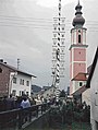
 Haunzenbergersöll from the southwest 2007
|
|
The parish village of Haunzenbergersöll is located in the western Isar-Inn hill country of the Bavarian Alpine foothills in a valley basin formed by the Eschlbach, a left tributary of the Rott , which flows into the Inn on the left .
It is part of the “structured cultural landscape ” and the “landscape worthy of protection with deficits” of the “ Rottal and Hügelland area around Taufkirchen ” in the large Alpine foothills according to the classification of the Federal Agency for Nature Conservation .
In addition, Haunzenbergersöll belongs to the "uncut, low-traffic area Isar-Inn-Hügelland between Velden and Neumarkt-Sankt Veit " according to the classification of the Bavarian State Office for the Environment .
The village is located on the southern edge of the Landshut planning region of the Bavarian State Development Program .
Politically, Haunzenbergersöll belongs to the municipality of Bodenkirchen .
The Roman Catholic parish of St. John the Baptist in Haunzenbergersöll is part of the Schönberg Parish Association in the Mühldorf am Inn dean's office in the Northern Pastoral Region of the Archdiocese of Munich and Freising .
history
The first historical mention of the village is uncertain . Since the place name Haunzenbergersöll is clearly formed from the two components Haunzenberger and Söll (the last to this day the short form of the place name), two lines can be traced back.
The noble family of the Hau (n) zenberger could be determined back to the first half of the 12th century and is to be addressed as the ministerial family of the Diocese of Passau . In the area of what would later become the village of Haunzenbergersöll, a Thomas von Hautzenberg first appeared in 1370 as the nursing magistrate from Neumarkt an der Rott .
The part of the name Söll possibly appeared as "Sel" for the first time in 1231 in the first Bavarian duke surbar .
Both components of the name only appeared together under Martin Hautzenberger, who is documented from 1454 and whose tombstone from 1469 has been preserved in the parish church in Haunzenbergersöll.
Around 1470 Haunzenbergersöll was a closed Hofmark (lower court district of the Haunzenberger sideline Söll). The rule of the Hofmarks came in equal parts to the nobles Tabertshofer and Neuhaus in 1609 and in 1628 as a whole to the nobles von Neuhaus auf Zangberg until 1807.
In 1820 a separate political municipality Haunzenbergersöll was formed, but in 1828 (officially not until 1849) the place was merged with the neighboring municipality of Bodenkirchen for fiscal reasons .


timeline
- 1130 Mention of "Wernhardus et Rupertus de Huzenberge" ( Traditions of the Diocese of Passau )
- 1231 first Bavarian duke surbar , mention of "Sel" (Haunzenbergersöll?)
- 1254–1282 "Ulricus de Hautzenperge" ( Ministeriale of Passau Bishop Otto von Lonsdorf )
- 1314 mention of the surrounding hamlets and deserts Eglso (in map: ⊙ ) Kremping ( ⊙ ), Upper Scrub ( ⊙ ) and lower rubbing ( ⊙ ) and mountain ( ⊙ ) among the places that donations to the Augustinian canons - pin Au am Inn had to do.
- 1370 Thomas von Hautzenberg was a nursing judge in Neumarkt an der Rott .
- 1389 Johann Hautzenberger sat in the village of Teising (on map: ⊙ ) near Neumarkt an der Rott .
- 1398 Ulrich Hautzenberger (his son) sold Teising.
- 1409 Ulrich der Haunzenberger sold the hamlet of Thal (see map here: ⊙ ) to the St. Veit monastery near Neumarkt an der Rott .
- 1443 Oswald Hautzenberger was rent master in Landshut .
- 1454–69 Martin Hautzenberger zu Söll (tombstone to the right of the church portal)
- 1460 Construction of the late Gothic church of St. John the Baptist
- 1470 Haunzenbergersöll became an independent noble seat and consisted of a castle with a pond and the Hofmark with 14 properties: 2 farmers , landlord , blacksmith , bathers , sexton , shoemaker and several smaller houses.
- 1504 Jakob Hautzenberger zu Söll was Kastner zu Neumarkt an der Rott .
- 1515 on February 25th, the brothers Georg, Friedrich and Jakob Hautzenberger zu Söll donated a benefice with a chaplain at the altars of St. Anne and St. Sebastian in the church of St. John the Baptist in Haunzenbergersöll.
- 1516 Georg, son of Jakob Hautzenberger zu Söll, was Kastner at Neumarkt an der Rott .
- 1518 Gravestone for the first Söller chaplain Stefan Tyllmersch in the nave of the church
- In 1563 Philipp Apian's Bavarian country tables mention a farm in Kremping (on map: ⊙ ) and a church in Haunzenbergersöll
- 1586 marble epitaph by Christoff Hautzenberger zu Söll in the church choir (right)
- 1609 Hofmark Haunzenbergersöll each went half to the Tabertshofer and the Neuhaus.
- 1622 marble epitaph by Friedrich Hautzenberger zu Söll in the church choir (left)
- 1628 Hofmark Haunzenbergersöll: Half of the Tabertshofers went to the Neuhaus auf Zangberg (until 1807).
- 1636 Sebastian Hautzenberger zu Söll ( care judge in Straubing ) died as the last of the male line of the Söll line.
- 1710 Bavarian topography by Michael Wening : copper engraving by Haunzenbergersöll
- In 1776 the church was decorated with wall paintings .
- 1790 the church got a new high altar , two side altars and a new pulpit .
- 1791 Construction of the Rococo church tower
- 1807 Death of the last Neuhaus: Maria Josefa Countess von der Wahl
- 1810 The Hofmarkschloss Haunzenbergersöll was demolished.
- 1812 the Bavarian original cadastre on limestone slabs showed Haunzenbergersöll and its surroundings.
- In 1820 the communities Haunzenbergersöll, Bodenkirchen , Bonbruck , Aich , Binabiburg and Rothenwörth (all now part of Bodenkirchen) were formed.
- 1828 Dissolution proceedings of the too small community of Haunzenbergersöll and their assignment to the community of Bodenkirchen
- In 1843 a survey of Haunzenbergersöll created the old village plan.
- 1844 Frieselfieber in Haunzenbergersöll and Schönberg : since then request on May 1st to Michaelhölzl (in map: ⊙ )
- 1849 Official incorporation of Haunzenbergersöll into Bodenkirchen
- 1868 hailstorm catastrophe: since then request to the pilgrimage church Maria-Hilf in Vilsbiburg
- 1887–98 neo-Gothicization of the church
- 1893 Foundation of the volunteer fire brigade
- 1897 the shooting club was re-established after a 15-year break.
- In 1902 a severe village fire destroyed the western part of Haunzenbergersöll.
- 1908 Establishment of the Roman Catholic branch Haunzenbergersöll of the parish of Schönberg
- 1910 electric light in the upper Bina valley : the establishment of an electric light and power station at the Pfistershammer sawmill in Bodenkirchen also provided Haunzenbergersöll with electricity.
- 1910 Foundation of the All Heil cycling club
- 1920 The small caliber - rifle club
- 1922 Foundation of the warrior and soldier comradeship
- 1952 on January 1st, the Haunzenbergersöll branch was elevated to the status of a Roman Catholic parish in Haunzenbergersöll.
- In 1965 a bypass road was built and paved.
- 1968 on September 6th, the Bavarian State Ministry of the Interior awarded the municipality of Bodenkirchen a new municipal coat of arms , which mainly consists of the crescents of the noble family of the Hau (n) zenberger. The coat of arms describes it: "In silver between two turned away black crescent moons a blue cross above and below".
- 1975 Find of a prehistoric mammoth tusk when excavating a pond near Thal (on map: ⊙ ), today exhibited in the local history museum in Vilsbiburg .
- 1978–1981 renovation of the parish church in three construction phases
- 1979 first village festival
- 1980 second village festival
- In 1981 the Haunzenbergersöll school , branch of the elementary school in Bodenkirchen , was closed.
- 1982 Lower Bavaria - Winner in the competition Our village should become more beautiful
- 1986 third village festival with singers' meeting
- 1988 Introduction of partly historical street names
- 1991 Parsonage inauguration after renovation of the old parsonage
- 1998 incorporation of the parish into the parish association of Schönberg
- 2000 “Bavaria's smallest folk festival ” in Haunzenbergersöll
- 2008 Reconstruction of the Holy Sepulcher from around 1900 in the parish church of St. John the Baptist and Passion Concert by the church choir
Monuments
The southwestern part of Hofmarkstrasse is entered in the list of protected monuments . The Bavarian State Office for Monument Preservation describes it as follows:
“The ensemble encompasses the south-western part of the village, which is designed as a straight alleyway with closed buildings leading into the corridor. Two smaller houses with flat saddle roofs , 18th / 19th centuries Century, are the oldest stock of this essentially planned system of the village, which was formerly part of a Hofmark ; the lock opposite has gone off. The buildings in the west were built after a fire in 1902 and were built in historicizing forms. The buildings, which appear urban in their complexity and appearance, go back to the tradition of the Hofmark artisan settlement. "
There is this entry for the parish church of St. John the Baptist :
“Catholic Church of St. Johann Baptist, late Gothic complex, 2nd half of the 15th century, tower raised in 1791; with equipment; Walled cemetery. "
literature
- Georg Schwarz, Vilsbiburg. The origin and development of the forms of rule in the Lower Bavarian region between Isar and Rott (Historischer Atlas von Bayern, Altbayern 37) Munich 1976, pp. 228–230 (Hofmark Haunzenbergersöll).
- Haunzenbergersöll - rule, Hofmark, church. For the 700th anniversary on June 28, 1980. Lecture by Rudolf Angermeier, ed. v. Heimat- und Gartenbauverein Haunzenbergersöll, Haunzenbergersöll 1980.
- Haunzenbergersöll in old pictures , ed. v. Heimat- und Gartenbauverein Haunzenbergersöll, Haunzenbergersöll 1981.
- Niederbayern (Monuments in Bavaria II) , arr. v. Sixtus Lampl and Wilhelm Neu, Munich 1986, p. 184 (Guns monuments in Haunzenbergersöll).
- 100 years of the Haunzenbergersöll volunteer fire department. Foundation festival with flag blessing, 18.-21. June 1993 , ed. v of the volunteer fire brigade Haunzenbergersöll, Haunzenbergersöll 1993.
- Martin Gröning, Martin Weindl, The old houses in Haunzenbergersöll , ed. v. Heimat- und Gartenbauverein Haunzenbergersöll, Haunzenbergersöll 1994.
- Georg Schwarz, the upper Bina valley between the rivers Vils and Rott. Art and culture in the parishes of Aich, Binabiburg, Bodenkirchen, Bonbruck, Egglkofen, Haunzenbergersöll, Treidlkofen (southern dean's office Vilsbiburg) and the community of Bodenkirchen , ed. v. Catholic rectory Bonbruck, Bonbruck 1994.
- 50 years parish Haunzenbergersöll , ed. v. the parish of Haunzenbergersöll, Haunzenbergersöll 2002.
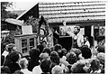
Auctioned at the village festival in 1981
Raising the maypole in 1982
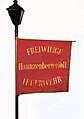
Historic standard of the volunteer fire brigade from 1893

Volunteer fire brigade in 1925
Flag of the volunteer fire brigade from 1956 (photo from 1993)

Church choir 1952

Advent singing by the church choir 1983
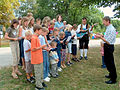
Söller Children's Choir 2003

FC Haunzenbergersöll 1933

Söller winter fun on the Wirtsweiher 1986
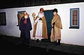
Söller Nikolaus, Krampus and Knecht Ruprecht 1986
Söller Carnival in 1952

Söller Prinzengarde 1952
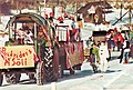
Söller carnival parade 1985


Web links
- Haunzenbergersöll in the location database of the Bayerische Landesbibliothek Online . Bavarian State Library (place name in books, historical maps, etc.)
- Haunzenbergersöll in the Genealogical Place Directory GOV
Footnotes
- ↑ Bavarian State Office for the Environment : Landscape Unit "Tertiary Hill Country (12)"
- ↑ Federal Agency for Nature Conservation : Map of Germany's large natural landscapes ( Memento from October 6, 2010 in the Internet Archive )
- ↑ Federal Agency for Nature Conservation : Landscape profile "Rottal and Hügelland around Taufkirchen (6001)"
- ↑ Bavarian State Office for the Environment : Profile of cultural landscape "Altbaierisches Hügelland (34)"
- ↑ Landshut planning region (13): Homepage
- ^ Bavarian State Ministry for Economy, Infrastructure, Transport and Technology : Bavarian State Development
- ↑ a b Parish Association Schönberg: Homepage
- ↑ a b Haunzenbergersöll Monument List
- ^ Historical atlas of Bavaria: Georg Schwarz, Vilsbiburg