Help
| coat of arms | Germany map | |
|---|---|---|

|
Coordinates: 52 ° 19 ′ N , 9 ° 7 ′ E |
|
| Basic data | ||
| State : | Lower Saxony | |
| County : | Schaumburg | |
| Joint municipality : | Nienstädt | |
| Height : | 58 m above sea level NHN | |
| Area : | 7.77 km 2 | |
| Residents: | 1921 (Dec. 31, 2019) | |
| Population density : | 247 inhabitants per km 2 | |
| Postal code : | 31691 | |
| Area code : | 05724 | |
| License plate : | SHG, RI | |
| Community key : | 03 2 57 013 | |
| LOCODE : | DE PPH | |
| Association administration address: | Bahnhofstrasse 7 31691 Helpsen |
|
| Website : | ||
| Mayor : | Manfred Kesselring ( SPD ) | |
| Location of the community of Helpsen in the district of Schaumburg | ||
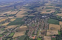
Helpsen is a municipality in the district of Schaumburg in Lower Saxony and, as a place of the joint municipality of Nienstädt, also its administrative seat.
geography
Geographical location
The districts of the municipality of Helpsen are located west of the district town of Stadthagen between the Bückeberg and the Schaumburg Forest in an open landscape. The distance to the cities of Stadthagen, Obernkirchen and Bückeburg is around 7 kilometers.
structure
The municipality of Helpsen consists of the villages of Helpsen, Kirchhorsten and Südhorsten. The focus of the settlement is on the Bergkrug.
Neighboring communities
Starting in the northeast, clockwise, borders on Helpsen: the district town of Stadthagen, the municipality of Nienstädt , the city of Obernkirchen and the municipalities of Seggebruch and Hespe . The communities of Helpsen, Hespe and Seggebruch together form the "Bergkrug communities".
history
Help
The place is first mentioned in 1208 as Helpersen . In a document, Bishop Heinrich von Minden transferred the tithe of seven Hufen to the Obernkirchen monastery. The manorial power lay with the Counts of Holstein-Schaumburg. When the county of Schaumburg was divided up in 1647/1648, Helpsen (like Kirch- and Südhorsten) came to the Lippe part and thus to the house of Schaumburg-Lippe. In 1871 the place was designated as a rural community together with the manor. From 1899 to 1948 the community belonged to the Bückeburg district and from 1948 to 1977 to the Schaumburg-Lippe district . On March 1, 1974, Helpsen, Hespe, Nienstädt and Seggebruch merged to form the Nienstädt municipality. Since August 1, 1977, the community has belonged to the Schaumburg district.
Kirchhorsten
Kirchhorsten is first mentioned as Hursten in an unconfirmed document from 1165 . The Bishop of Minden confirmed the donation of property from the nobleman Miribilis to the Minden church. The monastery Obernkirchen, the Minden church and the castle men of the Schaumburg had possessions here. At the beginning of the 13th century the place is also named as a church village. In 1847 Kirchhorsten received a railway connection to the Hanover-Cologne line. In 1925 the savings and loan fund (today Volksbank) was founded.
Südhorsten
In 1281 Südhorsten was first mentioned as Sudhorsten on the occasion of a transfer of ownership to the Obernkirchen Abbey. Overall, the pen was very wealthy here. The counts of Holstein-Schaumburg held the land and interest rule around 1627. Since 1757 coal mining has been named as a source of income. In 1871 Südhorsten was designated as a rural community.
Incorporations
On March 1, 1974, the communities Kirchhorsten and Südhorsten were incorporated.
religion
The Protestant Christians from all parts of the village belong to the Seggebruch parish. The Evangelical Lutheran Church is located there at the confluence between Schachtstrasse and Bergkrug.
From 1955 to 2010 the Catholic Church of the Holy Cross was in Helpsen . It was last a branch church of the parish of St. Joseph in Stadthagen, to which the Catholic residents of Helpsen belong today. The church was profaned on November 20, 2010 and demolished in 2011.
politics
Municipal council
The council of the community consists of eleven councilors and councilors.
(Status: local election on September 11, 2016)
Mayor / Administration
Mayor is Manfred Kesselring (SPD). The council has appointed the administrative specialist Stefan Kolb as community director. The community office is located at Bahnhofstrasse 29.
Culture and sights
- TV Bergkrug eV with the divisions basketball, tennis, table tennis, volleyball, gymnastics and health sports
- TuS Südhorsten with the divisions football and tennis
- Schützenverein Südhorsten with a shooting range
Two halls, a tennis facility and a sports park are available for sports activities. The building in the Südhorsten sports park is also operated as a village community center.
Economy and Infrastructure
Companies
- The largest employer is HAUTAU GmbH in the Kirchhorsten district. It is a leader in the field of hardware technology and automation for everything to do with windows and has around 300 employees.
- The Volksbank in Schaumburg also has a main office in Kirchhorsten. The Sparkasse Schaumburg is represented by a branch.
- Around 30 commercial enterprises complete the offer.
Public facilities
- The police station in Bückeburg is responsible for public safety and order. During the day shift, a station in Obernkirchen is manned by a branch in the joint municipality administration.
- The fire protection and general help by volunteer fire departments ensured Helpsen, Kirchhorsten and Südhorsten.
- A branch of the Schaumburg District Elderly Center is held in Helpsen. The house is run according to a house community concept.
education
In the pre-school area, a day-care center, a day-care center and a crèche are operated together with the Seggebruch community. For the primary school pupils there are teaching opportunities in Nienstädt and a branch in Seggebruch. An integrated comprehensive school is held in the school center. This includes a school sports hall and a district sports hall. Other secondary schools are located in Stadthagen and Bückeburg.
traffic
Street
The B 65 runs east of the municipality . The Bad Nenndorf and Bad Eilsen junctions of the BAB 2 can be reached in a short time .
The public transport is handled in the district Helpsen via a line of the company Rottmann and Spannuth (RSO). The SVG is responsible in the districts of Kirchhorsten and Südhorsten .
rail
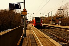
Kirchhorsten station is on the Hanover – Minden railway line . Its entrance building dates from 1847, the architect was Julius Eugen Ruhl . The station is served by the S-Bahn line S1 Minden - Wunstorf - Hanover . The trains run every hour. Regional amplifier trains of the Westfalenbahn also stop in the morning and in the afternoon .
Web links
Individual evidence
- ↑ State Office for Statistics Lower Saxony, LSN-Online regional database, Table 12411: Update of the population, as of December 31, 2019 ( help ).
- ^ Federal Statistical Office (ed.): Historical municipality directory for the Federal Republic of Germany. Name, border and key number changes in municipalities, counties and administrative districts from May 27, 1970 to December 31, 1982 . W. Kohlhammer GmbH, Stuttgart / Mainz 1983, ISBN 3-17-003263-1 , p. 200 .
- ^ Siegfried Lohr : Planning and buildings by the Kassel master builder Julius Eugen Ruhl 1796–1871. A contribution to the building history of Kassel and Kurhessen in the 19th century . Masch. Diss. Darmstadt [1982], p. 364.


