Abyssinia highlands
| Abyssinia highlands | ||
|---|---|---|
| Highest peak | Ras Daschän ( 4533 m ) | |
| location | Ethiopia , Eritrea | |
|
|
||
| Coordinates | 13 ° 14 ′ N , 38 ° 22 ′ E | |
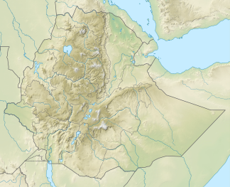
The highlands of Ethiopia ( highlands of Ethiopia , Abessinische Alps or Ethiopian highlands ) than to 4533 m high highland or high mountains in Central and North Ethiopia and Central and West Eritrea .
geography
location
The highlands of Abyssinia extend over the Ethiopian administrative regions of Amhara , Oromia and Tigray , as well as the Eritrean regions of Maekel , Debub , Gash-Barka and Anseba . In the north-west of Ethiopia it gradually turns into the Nubian Desert . In Eritrean territory, the landscape drops steeply to the Red Sea . In the southeast the highlands meet the northern part of the Great African Rift Valley , from which the East African Rift Valley branches off here. This begins with the Abyssinian Rift, which separates the Abyssinian highlands from the Somali highlands , which are also called the southern Ethiopian highlands . In the south, the mountains merge into the aforementioned rift valley , in which the Turkana Sea is located alongside several other lakes . The Nile valley and the swamps of the south adjoin to the southwest and west . The highlands are about 1000 km long in north-south direction and up to 500 km wide in west-east direction, which is roughly the size of the Alps .
Landscape image
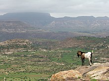
The Abyssinian highlands are characterized by wide plateaus, which are interrupted by deep gorges and overlooked by individual elevations, and the mean height of which is between 2500 m and 3500 m . The Simien Mountains represent an outstanding high mountain landscape with the Ras Daschän ( 4533 m ) as the highest elevation, as well as individual prominent elevations such as the Guna Terara ( 4120 m ). The southernmost branch is the Bale Mountains with Mount Tulu Dimtu ( 4377 m ) in the southeast of Oromia.
From the Nubian Desert in Sudan , which adjoins the highlands in the northwest , the terrain rises only gradually over the highlands and the border to Ethiopia . The Sahel zone stretches through the northern part of the mountains beginning in this border area : The latter comes in this area as a 100 km wide strip from the west and then bends to the north to break away from the northern part of the highlands with a width of up to 500 km along the coast of Red Sea and thus especially through the neighboring country Eritrea to the southeast.
At its eastern edge of the highlands of Abyssinia falls steeply to the west lies the border with Eritrea Koba Depression , a depression , on the shores of lake karum even to drop to 116 m below sea level; There is a marshland in it, which is fed by the streams and rivers that come from the very rainy center of the highlands. The eastern area is determined by dry and wet savannas , which merge further to the east into the broad strip of the Sahel.
In the southeast, where the above-mentioned rift valley runs through Ethiopia in a northeast-southwest direction, the highlands of Abyssinia merge over the moist savannah into the thorn savannah of the trench; there are many lakes in it.
The center of the mountains is mostly determined by grassland on the woodless and rocky table mountains, which often have vertically sloping rock faces. In the wars of earlier centuries, particularly striking rocky plateaus, called Amba , were impregnable fortresses, but also places of exile for members of the ruling families excluded from inheritance.
Towards the southwest and west, the terrain gradually slopes down over the dry savannah to the valleys of the Blue and White Nile .
mountains
The quite rugged high mountains are about 2000 to a maximum of 4533 m high. The highest peaks are sometimes covered with snow for long periods of time , one reason why the Blue Nile, which comes from Lake Tana and its tributaries, receives such abundant water.
To the mountains in the highlands of Abyssinia - sorted by altitude in meters (m):
|
|
Waters
The waters in and around the Abyssinian Highlands include:
Flowing waters |
Still waters
|
Localities
The localities in the highlands of Abyssinia include:
|
States
States with a share in the highlands of Abyssinia are:
geology
Rocks of volcanic origin shape the highlands of Abyssinia. In particular, there is a widespread lava cover up to two kilometers thick , which dates back to the activity of a magmatic large province 30 to 25 million years ago.
Climate and Agriculture
In terms of climate, the Abyssinian highlands are one of the rainiest areas on the African continent, especially in the areas above 2500 m , but concentrated in the months May to August. This leads to an agriculture tailored to the respective climatic conditions, which, depending on the altitude, focuses on cattle breeding (high mountains), the cultivation of wheat and barley (highlands) and the cultivation of Teff (average altitude up to 2500 m ). Overall, the Abyssinian highlands can be counted among the most fertile regions of East Africa due to the volcanic soil composition and the regular large amounts of rain in the summer months (with no frost all year round without high extreme temperatures). In some years, however, problems with below-average amounts of rain (at medium altitude; e.g. East Wollo in the 1980s) and "late rain" during the harvest season in December or January, which can lead to rotting of the ripe grain. A government program to build small, local (village) reservoirs minimized the risk of exceptionally dry years in large areas of the highlands. Annual precipitation amounts of up to 1800 mm in the high and highest altitudes contrast with those of around 1000 mm in the low foothills of the highlands (lower Dega ). As a result, the highlands are very heterogeneous in terms of the risk of drought. The problem is that in the event of a crop failure in a region of the highlands, due to the prevailing subsistence economy, there is hardly any possibility that other regions will also supply the affected region, also due to the lack of financial resources from both the state and those affected.


