
Hamburg-Neustadt
|
district of Hamburg |
|
|---|---|
  |
|
| Coordinates | 53 ° 33'7 " N , 9 ° 59'8" E |
| surface | 2.2 km² |
| Residents | 12,762 (Dec. 31, 2019) |
| Population density | 5801 inhabitants / km² |
| Post Code | 20354, 20355, 20359, 20457, 20459 |
| prefix | 040 |
| district | Hamburg-Mitte district |
| Transport links | |
| Federal road |
|
| Subway |
|
| Train |
|
| Source: Statistical Office for Hamburg and Schleswig-Holstein | |
The Neustadt ( Low German : Neestadt ) is a centrally located district between Hamburg-Altstadt and St. Pauli in the Hamburg-Mitte district of the Free and Hanseatic City of Hamburg .
The border to the old town is formed by an old estuary of the Alster , today's Alsterfleet , in the east, the Elbe in the south and the ramparts between the Elbe and the Inner Alster to the west and north. In the eastern part between Jungfernstieg , Gänsemarkt and Alsterfleet, the shops and offices as well as many Hamburg main branches of banks dominate, while in the west there are residential areas around Wexstrasse and Großneumarkt . The area around the Nikolaikirche , which historically emerged as a new town , is now part of the Hamburg-Altstadt district.
geography
Geographical location
The Neustadt is located in the center of Hamburg, west of the Alster. East closes Hamburg-Altstadt and west - beyond the city walls - St. Pauli on. In the north, delimited by the connecting railway, lies Rotherbaum and in the south, separated by the Elbe, Steinwerder .
District structure

For statistical purposes, the district is divided into four districts:
- The district 105, also called "southern Neustadt", includes the area around the Schaarmarkt south of the Seewartenstrasse - Rothesoodstrasse - Wincklerstrasse - Martin-Luther-Strasse - Pulverturmsbrücke and extends to the port . The Nordic seaman's churches are located here on Ditmar-Koel-Strasse, which also forms the center of the so-called Portuguese Quarter, as a disproportionately large number of Portuguese and Spaniards have their residence in this area and corresponding restaurants predominate.
- To the north of this, west of the Englische Planke - Ludwig-Erhard-Straße - Erste Brunnenstraße - Thielbek - Kohlhöfen - Poolstraße - Gorch-Fock-Wall - Jungiusstraße, is the district 106. This district includes the small and large ramparts and the old Elbpark large parts of the green belt that was created in place of the former city fortifications. The justice forum with the Higher Regional Court, criminal and civil justice building as well as the remand prison are also located in the Kleine Wallanlagen . Until the end of the 19th century, the main residential area of Hamburg's Jews was here and in district 107.
- The district 107 adjoins the district 106 to the east. It is bounded by the Kaiser-Wilhelm-Straße - Stadthausbrücke street . At the southwest end of the district, the Michel, is one of Hamburg's five main churches. The main synagogue (Kohlhöfen) and the Reform Jewish temple (Poolstrasse) used to be here.
- The northern part of the Neustadt is made up of the district 108. Today it is mainly characterized by the upscale shopping streets west of the Alsterfleet. In the northwest is the Old Botanical Garden. The Axel Springer publishing house also has its Hamburg publishing house here .
history


To the west of the Old and New Wall, which used to demarcate the city of Hamburg, the city originally housed disruptive but necessary facilities, such as B. brickworks, powder mills and the plague cemetery. Between 1615 and 1626 the Dutch fortress builder Johan van Valckenburgh built a new fortification which also secured this area. This protection, particularly important during the Thirty Years' War, led to the early settlement. However, it was not until 1685 that the parish church of St. Michaelis was elevated to the status of the main church and the Neustadt to become a parish with equal rights. Only then did the citizens of Neustadt achieve the same rights as the old town population. However, since the Hamburg middle and lower classes settled in the Neustadt, the Michaelis parish was later not as respected as the four other parishes , which is made clear by a verse from the middle of the 18th century:
- Saint Petri de Rieken
- Desglieken Sankt Nikolai
- Saint Catharinen de Sturen
- Saint Jakobi de Buren
- Saint Michaelis de Armen
- May God have mercy on this
The Neustadt was not only a poor quarter, but also a Jewish quarter, without there having been a ghetto or explicit Jewish alleys as in other cities. The (second) Jewish Liberal Temple , known for its reforms, was inaugurated in Poolstrasse in 1844 . In addition, various other Jewish institutions emerged, such as the Israelite Free School , which moved into a newly built house on the Zeughausmarkt in 1830 . When at the turn of the 20th century the majority of the Jewish population had moved from the Neustadt to Grindel , the community institutions followed suit, so that by 1933 - apart from a few residential buildings - there were hardly any specifically Jewish institutions to be found in the Neustadt.
The Neustadt is the only part of the city in which large-scale residential construction took place during the Nazi era , which was made possible by the extensive demolition of the extremely densely built-up “red Gängeviertel ”. The residential area around the Bäckerbreitergang had previously been torn down after the renovation had already started in 1890–1893 with the breakthrough of Kaiser-Wilhelm-Strasse.
After the Second World War, the moat was filled in with rubble. Only a small part of the former botanical garden is still preserved today.
In the 1950s, the east-west road was laid out as a central axis for through traffic from the Elbe bridges to the north-west; in the Neustadt area it is now called Ludwig-Erhard-Strasse. The six-lane road acts like an almost insurmountable barrier between the neighboring districts to the north and south.
The Dammtor Café, which was Munich's Hofbräuhaus until the 1980s , was replaced by a cinema complex.
In district 105, the Wallhöfe district development has been implemented since 2009 as part of urban redevelopment and renewal measures in the Neanderstraße, Neuer Steinweg, Hütten and Peterstraße areas ; As the winner of the competition , the architectural office Bieling Architekten is responsible for the urban planning . The new construction of the district east of the Holstenwall and north of Ludwig-Erhard-Straße includes office, hotel and residential buildings.
Population development
- 1895: 89,000
- 1920: 63,000
- 2002: 11,989
- 2006: 11,544
statistics
- Minor quota: 11.4% [Hamburg average: 16.3% (2017)].
- Elderly rate: 14.4% [Hamburg average: 18.2% (2017)].
- Proportion of foreigners: 20.3% [Hamburg average: 17.1% (2017)].
- Unemployment rate: 5.2% [Hamburg average: 5.2% (2017)].
The average income per taxpayer in Neustadt is 34,521 euros annually (2013), the Hamburg average is 39,054 euros.
politics
For the election to the citizenship , Hamburg-Neustadt belongs to the constituency of Hamburg-Mitte . The 2015 state election led to the following result:
- SPD : 41.0% (-4.5)
- Greens : 18.9% (+0.6)
- Left : 14.5% (+4.4)
- CDU : 8.5% (−6.1)
- FDP : 6.4% (+1.5)
- AfD : 4.4% (+4.4)
- Others: 6.3% (-0.3)
Culture and sights
music

In earlier centuries the Hamburg State Opera was housed on Gänsemarkt. Today's rooms were built in 1826 based on designs by Carl Ludwig Wimmel for the then city theater and rebuilt several times. Martin Haller built a first extension in 1873. The stage was rebuilt in 1925 according to plans by Distel & Grubitz . After the building burned down in World War II , it was rebuilt by Gerhard Weber between 1953 and 1955 . From the outside, it is a typical representative building from the 1950s.
The Laeiszhalle (music hall) on Johannes-Brahms-Platz owes its existence to a legacy from the shipowner Carl Laeisz, who died in 1901, and other donations from his widow Sophie. A late baroque brick building with two concert halls was built according to plans by Martin Haller and Wilhelm Emil Meerwein .
Buildings

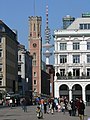
- The city's landmark, the Michel , cannot be overlooked. Below the Michel, the Krameramtsstuben give a small impression of the crampedness of the old residential areas. Today separated by the "Ost-West-Straße" is the first Michaeliskirche, the little Michel , since 1811 Catholic.
- The Bismarck monument (1906) by Hugo Lederer stands above the landing stages .
- The Hummelbrunnen by Richard Kuöhl in the new building area in the thirties.
- Lessing memorial , construction of the tax authorities and Germany House on Gänsemarkt
- Single home Hamburg on Rehoffstrasse, 1913. Architects: Heinrich Wilhelm Behrens and Ernst Vicenz.
- The Hertz-Joseph-Levy-Stift on Großneumarkt is still one of the collegiate houses with which wealthy Jews offered needy community members a home in old age. The Pelikan pharmacy, whose tradition dates back to 1696, is also on Großneumarkt. The sandstone facade of the building dates from 1780.
- The Paradieshof from 1762 has been preserved in the Alter Steinweg . At the end of the 1980s there were serious disputes in the Senate of the Free and Hanseatic City of Hamburg over the preservation of this monument . While Senator for Construction Eugen Wagner (SPD) wanted to demolish the house in the hands of the city and have it replaced with social housing, Senator for Culture Ingo von Münch (FDP) enforced monument protection and renovation for the building.
- The Anglican St Thomas Becket Church on the Zeughausmarkt was built by Ole Schmidt between 1836 and 1838 and is still the spiritual center of Hamburg's Anglicans .
- The Emporio skyscraper
- In the city center the Alte Post and the former Oberpostdirektion
- The Ellerntorsbrücke
- The Görtz-Palais , part of the town hall from 1814 to 1943
Holstenwall
Today the Holstenwall describes a street that was laid out in the section between the Holsten- and Millerntor of the ramparts . A number of representative buildings were built here:
- Brahms Kontor opposite the Laeiszhalle and the Justice Forum
- Museum of Hamburg History
- Hamburg Chamber of Crafts
- Commercial school
Peterstrasse
See Peterstraße and other cultural monuments around the Großneumarkt there .
Parks
- The old ramparts were converted into a park in which the old botanical garden has grown up: Planten un Blomen
- The Gustav Mahler Park at Dammtor
Economy and Infrastructure
Economically, the district is characterized by a very mixed use: There are many office buildings on the outskirts whose employees take care of business in numerous restaurants at lunchtime. Many restaurants and pubs are also open in the evening. a. around the Großneumarkt . There are many shops and offices / galleries of creative people. There is a small press quarter ( Axel Springer Verlag ) on Kaiser-Wilhelm-Straße and Caffamacherreihe .
See also
- List of streets, squares and bridges in Hamburg-Neustadt
- List of cultural monuments in Hamburg-Neustadt
- List of stumbling blocks in Hamburg-Neustadt
gallery
There are shopping malls such as the Alte Post in the northern Neustadt

The Hummel fountain was in former Gängeviertel built
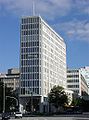
Axel Springer publishing house built in 1956 by Ferdinand Streb

From left: Hütten 100, Peterstraße 36, Peterstraße 34


Web links
- Neustadt on hamburg.de
- Common part of the city side of the residents and businesses in the Hamburg Neustadt
Individual evidence
- ^ Neighborhood development Neustadt / Wallhöfe in Hamburg-Mitte ( Memento from March 8, 2016 in the Internet Archive ). On: www.drost-consult.de, October 2008; Retrieved June 21, 2011.
- ↑ (gs): Start of construction for the Wallhöfe district . In: Die Welt from February 21, 2009; Retrieved June 21, 2011.
- ↑ Quota of minors in the Hamburg districts in 2017
- ↑ Proportion of 65-year-olds and older in the Hamburg districts in 2017
- ↑ Proportion of foreigners in the Hamburg districts in 2017
- ↑ Unemployment rate in the Hamburg districts in 2017
- ↑ Statistical Office for Hamburg and Schleswig-Holstein (ed.): Hamburg District Profile 2016 (= NORD.regional . Volume 19 ). 2018, ISSN 1863-9518 ( Online PDF 6.6 MB [accessed February 12, 2018]).
- ^ Result at the North Statistics Office. The Neustadt district must be searched for using the search function.
- ↑ Unsuitable for single households in FAZ of October 16, 2013, page 28
Billbrook | Billstedt | Borgfelde | Finkenwerder | HafenCity | Hamburg old town | Hamm | Hammerbrook | Horn | Little Grasbrook | Neustadt | Neuwerk | Rothenburgsort | Steinwerder | St. George | St. Pauli | Veddel | Waltershof | Wilhelmsburg