Horodok (Khmelnytskyi)
| Horodok | ||
| Городок | ||

|
|
|
| Basic data | ||
|---|---|---|
| Oblast : | Khmelnytskyi Oblast | |
| Rajon : | Horodok district | |
| Height : | 258 m | |
| Area : | 1,111 km² | |
| Residents : | 16,368 (2017) | |
| Population density : | 15 inhabitants per km² | |
| Postcodes : | 32007 | |
| Area code : | +380 3251 | |
| Geographic location : | 49 ° 10 ' N , 26 ° 34' E | |
| KOATUU : | 6821210100 | |
| Administrative structure : | 1 city | |
| Address: | вул. Грушевського 53 32000 м. Городок |
|
| Statistical information | ||
|
|
||
Horodok (Ukrainian Городок , Russian Городок / Gorodok , Polish Gródek ) is a city in the southern part of the Ukrainian Oblast Khmelnyzkyj with a little more than 16,000 inhabitants (2017).
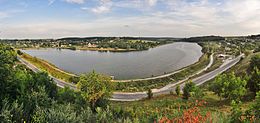
Horodok lies on the bank of the Smotrych . The regional road P-50 and the territorial road T-23-12 run through the city .
history
The settlement was first mentioned in writing in 1392 and has been a city since 1550. In 1916, a train station was built east of the town on what is now the Butschatsch – Jarmolynzi line, connecting the city to the railway network. From July 8, 1941 to March 25, 1944, the city was occupied by Wehrmacht troops.
Web links
Commons : Horodok (Khmelnyzkyj) - collection of images, videos and audio files
- Gródek . In: Filip Sulimierski, Władysław Walewski (eds.): Słownik geograficzny Królestwa Polskiego i innych krajów słowiańskich . tape 2 : Derenek – Gżack . Sulimierskiego and Walewskiego, Warsaw 1881, p. 818 (Polish, edu.pl ).
Individual evidence
- ↑ Cities and Settlements of Ukraine on pop-stat.mashke.org ; accessed on June 11, 2018 (Ukrainian)
- ↑ a b Local history of Chornyvody in the history of towns and villages of the Ukrainian SSR ; accessed on June 11, 2018 (Ukrainian)


