
Isonzo
|
Isonzo Soča |
||
 |
||
| Data | ||
| location | Slovenia , Italy | |
| River system | Isonzo | |
| Drain over | Isonzo → Adriatic Sea | |
| source | in the Julian Alps 46 ° 24 ′ 43 ″ N , 13 ° 43 ′ 21 ″ E |
|
| Source height | 1100 m. i. J. | |
| muzzle |
Gulf of Trieste south of Monfalcone Coordinates: 45 ° 43 ′ 29 " N , 13 ° 33 ′ 22" E 45 ° 43 ′ 29 " N , 13 ° 33 ′ 22" E |
|
| Mouth height | 0 m slm | |
| Height difference | 1100 m | |
| Bottom slope | 8.1 ‰ | |
| length | 136 km | |
| Catchment area | 3400 km² | |
| Drain |
MQ |
170 m³ / s |
| Left tributaries | Lepena , Idrijca , Vipava / Vipacco | |
| Right tributaries | Koritnica , Torre | |
| Medium-sized cities | Gorizia | |
| Communities | Bovec , Gradisca d'Isonzo | |
 Soča near Kobarid |
||
The Isonzo ( Italian ), Soca ( Slovene ), also Sontig (historical German name) Lusinç ( Friulian ) is a river in the historic Slovenian region Goriška and in the Italian region of Friuli-Venezia Giulia .
The river

The Soča rises in northwestern Slovenia from a karst spring at the foot of the Travnik ( 2379 m. I. Year = m. Above the Adriatic Sea) in the Mangart - Jalovec massif in the Julian Alps , has a length of 140 kilometers and flows south of Monfalcone into the Gulf of Trieste .
The karst spring is located in the Triglav National Park near the Vršič Pass (1611 meters), which connects the town of Trenta on the Soča with Kranjska Gora ( Kronau ) on the other side of the Triglav National Park. The Lepena flows into the Soča from the left at the level of Soča, and the Koritnica flows into the Soča from the right near Bovec . In this section the Soča flows into a 750 m long and 10 to 15 m deep limestone trough gorge. The oldest hiking trail in the national park (around 20 km long) crosses the river in several places over swinging wooden-clad suspension bridges.
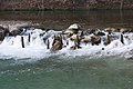
From the mouth of the Lepena through the gorge to the village of Kobarid , the Soča is a challenging white water route for canoeists and other water sports enthusiasts . Anglers appreciate the abundance of marble trout .
The pure water of the Soča appears crystal clear and turquoise blue. Due to the special location of the Soča (the valley is open to the south to the Mediterranean Sea), the climate there is extremely mild both in spring and in late summer, the sun shines down to the bottom of the gorge at noon.
From Gorizia the river enters the eastern end of the northern Italian lowlands , flows through Italy in its last quarter and, on its lower reaches in the coastal plain of Friuli, carries large amounts of debris into the Adriatic. Here the Isonzo forms a wide gravel basin typical of this region ( torrente ), which changes with every flood and requires long bridges - in summer, however, only a small trickle flows there.

The main source of the Soča
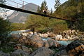
Suspension bridge in the Spodnja Trenta

Gorges of the upper Soča

Soča above the mouth of the Koritnica
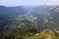
The upper Sočatal around Bovec

White water paddling on the Soča

Just before Kobarid

Alluvial landscape in the lower Sočatal near Tolmin

The reservoir at Most na Soči at the Idrijca estuary

The Soč breakthrough shortly before Nova Gorica

Beginning of the lower reaches at Gorizia

Isonzo falling dry to Gorizia
Remains of the Roman Bridge near Mainizza ( Farra d'Isonzo )

Riserva naturale della Foce dell'Isonzo at the mouth

Camargue horses at the mouth of the Isonzo


.jpg)


.jpg)
_river_near_Kobarid_2.jpg)


.jpg)
.jpg)
.jpg)
.jpg)
.jpg)


History and culture
Roman times
The Isonzo was called in Latin [Fluvius] Sontius , although in some sources it was a tributary of the Fl. Frigidus , which is believed to be the Vipava / Vipacco . But it was also assumed that the Frigidus is also the Isonzo (possibly with the Idrijca as the upper course), because the Tabula Peutingeriana shows the Via Gemina Aquileia - Emona (Ljubljana), the Roman Amber Road and the main route to the inner Balkans, as it is not far from Ponte Sonti (Ad Pontem Sontii) , 14 miles to Aquileia (unlocated in the area of Gradisca / Savona) and about north of Fonte Timavi (sources of Timavo ) the Frigidus crosses: the Via Julia Augusta towards Noricum passes (ad silanos) roughly north of the "Forest" from which the Frigidus arises, so perhaps the whole Julian Alps are represented here. This is supported by the river name and the "extraordinary cold" that Claudian mentions, the Vipava is not particularly cold as a flatland river. Perhaps the Roman geographers were already at odds about the main course: Herodian describes the river - without naming it - as "large and excellent, especially in spring and summer fed by the melting waters of the Alps": This does not apply to the Vipava either the torre. On the other hand, Castra ad Fluvium Frigidus was probably near Ajdovščina , and the Battle of Frigidus 394 is located between Ajdovščina and Vipava , perhaps the Vipava River was considered the upper reaches of the Frigidus. In any case, it is archaeoclimatically possible that the Isonzo was not a torrente in the lower reaches of the Roman period, but a regularly flowing Alpine river. The Tabula Peutingeriana shows the confluence into a large lagoon, not - as it is today - directly into the Bay of Trieste. The Vipava, too, could have been much richer in water and fed by numerous cold karst springs.
Roman settlements are also documented on the upper Slovenian Isonzo (Sočatal), and a road over the Robič .
Twelve battles of the Isonzo
→ Main article: Battles of the Isonzo
When Italy declared war on Austria-Hungary on May 23, 1915 and then attacked during World War I , a new front was formed, partly in the high mountains , from the Dolomites to the Isonzo in the east . In June 1915, the first of four Isonzo battles that year was launched in the eastern section, in the valley of the Isonzo, followed by five more offensives in 1916 and two more offensives in 1917. The Italians did not make the breakthrough in the direction of Trieste and the Ljubljana Basin. The total of eleven Italian offensives claimed hundreds of thousands of deaths, and the city of Gorizia was taken by Italian troops. Since the Austro-Hungarian army acted defensively in the eleven battles, the next battle was now planned as an offensive. Emperor Karl took over the command himself. With the use of poison gas and the support of German troops, the last battle on the Isonzo began on October 24, 1917 with the breakthrough at Bovec . This Twelfth Battle of the Isonzo (referred to by the defeated Italians battaglia di Caporetto (Slovenian: Kobarid ) and by the victorious Central Powers as "the miracle of Good Freit") ended with the allied troops reaching the Piave on November 10, 1917. There was the front then until the collapse of Austria-Hungary.
Viticulture on the Isonzo
On both sides of the Italian course of the river there is a wine-growing region of the same name.
literature
- Marko Simić: On the trail of the Isonzo front , Mohorjeva Hermagoras, Klagenfurt-Laibach-Wien 2004; ISBN 3-85013-884-4
Web links
Individual evidence
- ↑ a b So´ntius. In: Hopper: Dictionary of Greek and Roman Geography 1854 (online at perseus.tufts.edu).
- ↑ a b Frigidus Fluvius. In: Hopper: Dictionary of Greek and Roman Geography 1854 (online at perseus.tufts.edu).
- ↑ cf. plus Luisa Codellia, Antonello Cian: I ponti romani sull'Isonzo / Rimski mostovi na Soči. (pdf, isonzo-soca.it) - with excerpts from the Tabula Peutingeriana (Italian).