
Cologne's Jewish quarter
The Cologne Jewish quarter was the oldest dwelling place of a Jewish community north of the Alps . Jews have probably been settling in the provincial capital of Lower Germany since the end of the 1st century and formed a supraregional community up to the 4th century, which, like the other residents of the urban core area, built their houses on the remains of Roman buildings. Its existence was first mentioned by a decree of Emperor Constantine of the year 321 AD. The Jewish residents of the quarter were expelled from the city of up ewige tzyden (for all times) in 1424 after a one-year period set by the council in 1423 .


history
Settlement in Roman Cologne
The imperial decree of 321 issued to the “decuriones” of the CCAA , which also allowed Jews to be appointed to the “ curia ” or, if necessary, to hold them accountable against their will, is the earliest evidence of the existence of a Jewish one Parish in the city of Cologne. The decree is handed down in the Codex Theodosianus and had the following wording in the translation:
“We permit all city senates by general law to appoint Jews to the curia. So that they have a certain amount of compensation for the earlier regulation, We allow that two or three should always enjoy the privilege not to be used by any appeal (to offices). "
According to this, Jews were already a part of urban life before the Frankish conquest and, since they were a merchant people and not an arable farmer, they were likely to have their business partners and their place of residence in the core area of the city in the following years as well.
Persistence in Frankish times
Whether the late antique collection of laws in the Codex Theodosianus existed in post-Roman Cologne is just as unknown as the further status of the Jewish community in Franconian times. However, the most recent excavations on the site of today's Town Hall Square , a part of the city's archaeological zone, which is being developed as a museum complex, certainly confirm the existence of the synagogue there in the late Carolingian period. Predecessor buildings of the Jewish house of God are supposed to go back to the first half of the 4th century.
Mentioned in the High Middle Ages
It was not until the 11th century that they were once again documented as a Jewish community in Cologne, in which the Jewish quarter was named as "inter Judeos". This emerged from a letter sent by Archbishop Anno to the St. Andreas Abbey , in which the latter donated a piece of land to the Abbey in the Jewish quarter. It was the same property whose building “iuxta domum Divium” was sold by St. Andreas to the Jew Elyachim. Jews had settled in many medieval cities such as Cologne within such districts, which were mostly designated as “inter Judeos” and assigned to the Jews for settlement.

The primarily trading Jews were initially allowed (as in Frankfurt and other cities), in contrast to the Frisian merchants who later settled in the St. Gereon district, to settle within the city wall on the eastern edge of the same. So you distanced they also spatially far from the west front of St. Apostles located early medieval commons , their use was not permitted.
A bourgeois community of Jews and Christians existed only sporadically in the High Middle Ages. It was shown for a short time in a common jurisdiction, in that statements of both groups were recorded in joint books. It was the same with another municipal measure in which they had to take on virtually the same duties as they were taken on by other municipalities. As the expansion of the year 1106 bund had taken place, the Council referred the Jews that their neighborhood first location city gate in defense and named it after them as Jews gate. The section "Ipperwaldgraben" and the cube gate for defense were given to the Christian population of the St. Laurenz district . The Jews had to fulfill civil duties as required, and hardly any rights were granted to them. The burial of their dead had to take place outside the city walls and was still controversial there. Only a privilege granted by Archbishop Engelbert in 1266 brought a provisional settlement. On the other hand, Jews were at all times the partners and financiers of high-ranking gentlemen of the citizenry in various financial transactions. This ambivalent behavior of the early Cologne population in the coexistence of these two population groups had ups and downs and was not to change until the expulsion of the Jews in 1424.
Districts and streets according to group affiliation
Initially, the Jews were able to pursue almost all professions, but they were limited to their traditional skills and abilities. In their old quarter, they were mainly active as traders in money and livestock, were recognized good silver or goldsmiths and doctors , who were even used by the Christian citizens in the worst of times.
In the neighborhood of the Jewish quarter, for example, the painters and sign makers of the Schildergasse were located, above the quarter was the Hochstrasse , which was divided into the sections of the blacksmiths , Sponmacher, Kannengießer and breakdown beaters, while the hat and bag makers, silk stickers and other professions of that time were represented. Members of this diverse craftsmen later organized themselves into powerful guilds and thus influenced the political life of the city. All of them had settled individually or in professional groups, but mostly in a certain neighborhood or street in which they lived and worked for generations.
In Cologne it was the ethnic group itself that, as in almost all medieval cities in Europe, lived in a separate quarter named after them. In Cologne's Jewish quarter, too, the largest street in the quarter was known as Judengasse . Other historical street names were Jerusalemgässchen and Salomongasse, the gold and silversmiths of the arts and crafts coined the name of the street Unter Goldschmied. The street name was in contrast to Goldgasse in the Rheinvorstadt (which later became Strassburgergasse) or Goldgasse ( platea auri ) in the northern suburb of Niederich , which was named after landowners of that name who lived there in the 12th century, purely related to the craft of Christian and Jewish goldsmiths.

The goldsmiths, which were at the forefront of the ranking and were listed in fourth place in the composite letter of 1395 , also belonged to the guilds that were becoming more and more established . After the adoption of this “Basic Law”, it was only a few years until the goldsmiths known as “goltsleigere” ( Gaffelhaus “Zum golden Horn”, 1401 until the end of the imperial city period, Unter Goldschmied 1), as manufacturers of gold leaf and gold jewelry, their Jewish ones Competitors no longer had to fear.
The craft based on this street has recently been evidenced by typical tools such as the discovery of a crucible dating back to the 13th century . The alleys of the traders with their stalls called stalls probably gave their name to the Kleinen- and Große Budengasse, streets that were still there with so-called "Gaddenen" after the expulsion of the Jews into modern times .
On the north side of Unter Goldschmied was the "Botengasse", today's Grosse and Kleine Budengasse of the traders. The Judengasse , known as "Jüddejas" in colloquial language, was the boundary of the east side of the quarter. It was built on on both sides and was not yet interrupted by a free space. In the middle of it, on the side of the street facing the Alter Markt, was the “House of the Citizens”, today's town hall. It was located in the topographical core of the city, but like the seat of the bailiff in the north of the district, it was surrounded by residents of a different ethnic and religious affiliation. For these residents, on the other hand, it was not Cologne residents who lived on the other side of the streets, but Christians.
Vogtshof zur Stesse

The quarter along Judengasse initially had the area of a narrow rectangle, which only reached its later width on Engen Gasse. On its west side, for about a century, was the mayor's court. The Hofstatt, located next to the St. Laurenz church, was built between 1200 and 1230 as a cathedral. advocati in atrio s. Laurenti , later also dom. cum ar. Hermani maioris advocati retro p. Laurentium and then dom. called et curia nobilis advocati . It had become the seat of the Cologne bailiffs in 1263 and apparently remained that way until 1370. By that year, the material to be saved from the city archive was transferred to the Vogtshof zur Stesse.
Growth and dimensions of the quarter


The Jewish quarter had developed over centuries in the old town center of the later parish of St. Laurenz, first mentioned in 1172 and 1176. When the Jewish community grew rapidly at the beginning of the 14th century, the property passed house by house to the Jews, especially on the northern edge of the district in Kleine Budengasse. The council responded with the measure that the Jewish buyers had to pay a quarter of the purchase price to the municipality and at the same time stipulated that the new houses should be given a pension of six shillings in favor of the parish of St. Laurenz.
The core of the entire quarter lay above Judengasse , which originally with its buildings built on and partly on the Roman east wall ran between the streets “Oben Marspforten” and Botengasse (later and still today “Kleine Budengasse”). The area covered the “Enge Gasse” (today's Portalsgasse) along with the entire Judengasse, the Jerusalemgässchen was relatively short, it ran parallel and east of the street “Unter Goldschmied” and had its access from there. To the north and above Unter Goldschmied was the small Salomonsgasse (still today) and the “Kleine Gasse” in this section became today's Laurenzgittergässchen. In the course of time, Jewish property and houses expanded from these streets and included neighboring streets. In parts of the streets Unter Goldschmied, Oben Maarspforten and Marsplatz, short pieces had passed into Jewish ownership, while the street Kleine Budengasse was almost entirely owned by Jews around 1349.
Inclusion of the quarter and its gates
Since 1310 the Jewish quarter was completely closed on the east and north sides. A wall erected by the Jews themselves was mentioned in the documents, which demarcated the Christian houses in the direction of the Alter Markt , but it cannot be ruled out that they were obliged to do so. The shrine entry for the St. Brigida district reads: “Cpm. 1310 “, anterior dom. de novo muro edificato a Judeis usque ad Antiquum forum, dom. retro .
Another entry from 1341 gives information on a total of five gates in the Jewish quarter. The entry reads: “One of the counselors has keys from the Jewish porce and door, should lock them in the evening and open them early in the morning; the key to Engeggasse is reserved for the Jewish bishop according to the Jewish letter ”.
The north side of the district on Kleine Budengasse had been closed by bars that were pushed forward with the expansion of Jewish residents. On this street, first called Botengasse, there was a gate on both sides, the western one at Unter Goldschmied and the eastern one at Judengasse. This in turn had a gate at the end of the street Unter Taschenmacher in the northeast, as well as one at its southeastern beginning on the street Oben Marspforten / Marsplatz. The fifth gate of the quarter was the entrance to Engen Gasse from the Unter Goldschmied side. According to the shrine books, the northern Judengasse was given the name Bürgerhaus- and then the name Bürgerstraße around the middle of the 14th century. In 1341 the narrow alley through the "porta inferior" formed the northern entrance to the Jewish quarter.
Real estate in the Jewish quarter
When the Cologne special communities were formed, the Jewish quarter fell almost entirely into the area of the parish of St. Laurenz , only the Jewish residents who moved into apartments in the houses built on the Roman wall fell administratively to the later Brigidenpfarre (1172) in the Rheinvorstadt .
Shrine books and evaluations

Since about 1130 the city were in the communities Schreinsbücher , according to current understanding basic books out. This communal institution of the districts in its early days in the Laurenz district covered Christians and Jews without distinction. Soon, however, separate shrine registers of the Jewish real estate were created especially for the Jewish real estate, which Jews could essentially only acquire in the old town of Laurence Parish. From these, Robert Hoeniger evaluated the entries from the 30s of the 13th century to the year 1347 for his special treatise .
Hoeniger's research was based on around 50 houses and farmsteads from 1235 that were now owned by Jews. This stock, on a relatively small area of the district they dominated, grew to 60 properties by 1300 and increased to 70 in 1325. The only slight increase to 75 buildings belonging to Jews around 1340 can be explained by the escalating anti-Judaism that culminated in the pogroms of 1349.
According to Hoeniger's evaluations, the officials of the Laurence District were the certifying authority for both Christians and Jews. Only in a few controversial cases of inheritance law , marital property rights or guardianship was the participation of the Jewish community leadership (it consisted of a twelve-member council and a so-called Jewish bishop) to be found in the documents. In comparable cases, in Christian legal transactions, a judgment of the lay judges decided on the disposition authority of the opposing parties.
At the beginning of the sixties of the 13th century, a sporadic settlement of legal transactions began in front of the synagogue building . These privately negotiated deals were attested to in 1266 by the "Judenbishop" and the Judenrat before the shrine office. Thereafter, this procedure varied, the documents drawn up in Hebrew became more common, but they were rarely referred to in the Latin documents. From the end of the 1380s, reference became the rule and the Jewish authority became the sole authority.

As a rule, negotiations and notarization before the shrine office only took place if the seller was a Christian citizen. The Hebrew certificate was missing in such cases, and the entry was not made in the Jewish shrine, but in the Christian shrine books intended for these legal transactions.
In this work, Hoeniger summed up that the Jewish quarter of Cologne could only be referred to as a ghetto to a limited extent .
In comparison to this earlier work, Keussen examined and evaluated all available years of the districts of the entire city area. Since Keussen did not find any Hebrew names in the shrine entries there in the urban districts with the exception of the Laurence Parish and on the eastern outskirts of the Laurence district to the St. Brigida district, he came to the opposite view.
The created maps (Sc. Jud. = Scabinorum Judaeorum) contained the notarizations of Jewish real estate and, in terms of content, followed directly from the previous entries on the shrine maps of this district. As for the rest of the population, all property transactions such as purchase, inheritance and donation of property were recorded. Inheritance, loan and time leases, pledges or other encumbrances in rem were concluded in front of the officials' colleges in the respective sub-districts in which the property in question was located and recorded in the shrine files.
Adolf Kober , historian and rabbi , pointed out that around 1236 special shrine registers were also created in the other sub-districts (the north-western edge areas) of the Laurence Parish. So the Jewish shrine would have been just one of many, so its existence does not necessarily have to be understood as a sign of the incipient exclusion.
Documents of the past

Comparable entries from different centuries reflect the upheavals in the Jewish quarter. The following section gives an insight into the mediaeval conditions in the individual cases cited as examples.
- 1170, a house in the Judengasse in the regular (Christian) shrine book: (Robert Hoeniger, Moritz Stern (ed.): Das Judenschreinsbuch der Laurenzpfarre zu Köln , I 222) “dom. cum ar. in angulo platea Judeorum versus Corduanos, illa pars, que spectat ad Judeos, que erat Wollberonis Litherin et Hertwici fratris Gerardi Teleonarii; is made by the Jew Jac. fil. Ysaac bought ”.
- 1279, house on the southern "Enge Gasse" (Portalsgasse) below the street "Unter Goldschmied". (Jschr. N. 138) “dom. Solomon, bishop of Judei (†) ”. Because of his knowledge of the city's Jewish history, Wallraf is likely to have reintroduced the old name "Salomonsgasse" after the French period.
- 1280, Jewish community center. (Jschr. N. 139) “House that belongs to the Jewish community together with Rabbi Juda, the son of Rabbi Moses”. In the same year, adjacent land was acquired. Also under (Jschr. N. 139), “dom. secunda a domo cer Misten versus sinagogam Judeorum: the courtyard of the house is acquired by the Jewish community to expand the synagogue courtyard, which is adjacent to the south ”.
- 1288, a house in Jerusalemgässchen in a separate Jewish shrine book: (Jschr. N. 173. 176. 181/183. 232; Qu. 3, 305) “dom. universitatis Judeorum, que dic. Speilhůz; it was the bridal or wedding house, which was primarily intended for holding weddings. It was in the south of the Aschpa house (zur Misten, Portalsgasse 16) and stretched out to the neighboring house. To the east it was adjacent to the (Jewish) schoolyard and had its entrance there. In 1288 it had been owned by the municipality for over 30 years. The purchase of a building was also recorded for 1288, which subsequently served as a bakery for the Jewish community. It was the back house of Nichol at Oben Marspforten south of Jerusalemgässchen, a former property of the goldsmith Theoderich Metz "
After the first eviction
- In 1349 the so-called “Jewish fire” occurred in Cologne , also supported by the rampant plague , for which people were looking for guilty parties. During these events, many residents of the Jewish quarter were killed or displaced and numerous houses in the quarter on Judengasse were burned down.
- After 1349 the S. Brigiden shrine to the eastern Judengasse recorded: “Doors to the Christengasse closed, walled up. By 1359 29 houses and 28 house spaces sold to the Jews ”.
- 1366, (Sc. Jud. 1366) seventeen years after the pogrom it was said for a house on the north side of the later Portalsgasse (today “Spanish building”), “Hfst. called the long Huys very soon the Hfst. the Kemenaids; is given to the goldsmith Gerhard Langin by the commissioners of the Jewish property ”. It was not until 1372 that the council's attitude changed, and now the Jews were allowed to resettle in the Judengasse quarter. In 1373, for example, the council rented Salomon a “Huys in der Jůdingassin” to the Jews for four years at a rent of 48 guilders per year.
- Gravestones of Cologne Jews of the 14th century

Oldest known gravestone of Cologne origin

Rachel's tombstone , 1323 (see caption)
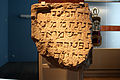
Without naming

Gravestone of Sara, daughter of R. Menachem


Community institutions
Water supply and sewage
The district was supplied with water through a draw well called "Pütz" . They were located on Grosse Budengasse, Sporergasse, on Judengasse above the town hall and the large Pütz des Judenbad with stone spiral staircases, known as Kaltenborn.

However, not much of the exemplary Roman sewer system was preserved in the Middle Ages. The derivation of the waste water was to call in all neighborhoods of the city to be defective, only for the resulting feces to hub septic tanks from. In the 12th and 13th centuries, the roofs had only one eaves , or the rainwater of the "Kallen" ( gutters made of lead had been known since the 12th century ), as well as the fallow water from the houses, was led to the alley and looked for its own there downhill path. This open sewage in the street area, called “Soden” in Cologne, was gradually laid in trenches and covered with planks, which were then called “Aducht”. The downhill main sod, also covered later, was the particularly wide sod Oben Marspforten in the south of the Jewish quarter, which even had a footbridge in the area of the coin . On the north side of the quarter, the ancient sewer system leading towards the Rhine under the Budengassen is likely to have been used, of which parts with a total length of 145 meters are still preserved today.
Synagogue structures
The predecessor buildings of a Jewish church, which may have been built in the first half of the 4th century, were followed by the synagogue of the medieval community, also known as the Jewish school , and was built in 1012 or 1040.
According to the testimony of Elyakim ben Josef from Mainz († between 1145 and 1152), the building was decorated with glass paintings, which with their lions and snake images were among the first glass paintings in the Rhineland. The synagogue was destroyed by the crusaders moving towards Jerusalem in 1096 and was rebuilt in 1165 at the latest. This building survived the first expulsion of the Jews from Cologne around 1349/50 and the time until their return in 1372, but only came back into the possession of the community in 1378. Just two years after the final expulsion of the Jews, the synagogue became a Christian house of worship in 1426, the Council Chapel of St. Mary in Jerusalem .
Social and cultural center
With around 800 people of Jewish affiliation living in a relatively small area, this special community in Cologne developed into a center of German Jewry in the first half of the 14th century . The Jewish quarter of Cologne was considered a stronghold of scholarship , in which traditional Talmud studies were in the foreground. In connection with a literary legacy of Cologne rabbis , the names of Elieser ben Joel Halevi, Abraham Achselrad and Samuel Halevi were cited, who had a significant influence on European-Jewish intellectual life.
Other facilities

As in the Christian parishes, the Jewish house of worship, the synagogue, was the center of their quarter. The synagogue was surrounded by other community facilities, such as the synagogue servant's apartment, the schoolyard enlarged in 1280 through purchase of land, the women's school south of the synagogue, first mentioned in 1281, and the community and "Spillhuys" which burned down in 1349, where the weddings took place. A hospital (1248) as a charitable institution was one of the buildings that were probably jointly maintained , as was maintained for the sick and elderly residents in the rest of the city by parishes or convents. Neither denomination , however, paid equal attention to religious affiliation . While Jewish doctors were also in demand with Christians, the Hospital Haus Grunewald was opened in 1308 on Maximinenstraße (also All Saints' Day) to accommodate poor converted Jews. The institution was founded by Hermann de Ederne and Adolph de Reven. Other facilities were a generally used water basin (possibly a washing area) and the community's important ritual bath, the mikveh.
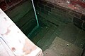
Kaltenborn, Judenbad, mikveh
The first construction phases of the mikveh go back to the time before 800. A renovation followed after 1096, which, apart from a tower-like superstructure (which stood until the 17th century), is still preserved today.
A shrine entry from 1289 for the house of Liv (b) ermamm (Jschr. N. 188 reads "parva dom. Contig. Dom. Lyvermanni versus dom. Civium"). “The house with the yard next to the school yard and the bath (the name Bad, Judenbad also appears as Kaltenborn or Judenpütz and was probably the ritual bath of the Jewish quarter known today as Cologne Mikveh ) south of the yard of the Bardewich u. the big house that R. Livermann from Düren built opposite the Marspforte ”. A final certainty regarding the exact location of individual facilities will only be given after the current excavations have been completed.
Entrance and adjoining excavation area

Upper shaft

Round arch detail
Basin and today's level measurement


Mikveh

The well shaft of the plant had a tower-like superstructure, the small arched windows of which gave the deep shaft little light. The shaft changes below the staggered arched openings from an outer staircase to the inside. It reaches the groundwater level of the Rhine at a depth of approx. 17 meters and thus fulfilled the ritual requirements that required and made immersion in "living water" possible.
Community center
On the site of the Jewish quarter, which has been densely populated since Roman times and later, a first house of the citizens was built on the eastern edge. It served as the administration building of the Richerzeche , the political head of the city, and was of modest size. The later expanded building rested partly on the Roman and Franconian masonry of the previous buildings, the foundations and vaults of which can still be found in the basement, but also had a beam anchorage as a beam in the wall of a neighboring Jewish building. This early form of the later town hall burned down with many other buildings in the area during the pogrom in 1349. This was proven by the traces of fire found in 1864 and the fact, documented for 1352, that the council meetings took place at the time in the Airsbach office on Mühlenbach Street. The loss of parts of the shrine files from this time can be explained, as well as the construction of a new hall (later called Hansasaal), which took place around 1360 at the old location on Judengasse . The ever-growing complex of the “community center” took over many of the adjoining residential and commercial buildings through confiscation or purchase and in 1915 covered an area of around 2200 m² with a length and width of around 74.50 × 42.50 meters. The so-called Plasman House, whose vaulted cellar, next to the mikveh and the historic Löwenhof, will be on view in the tour program of the future archaeological zone, was also integrated into the complex, which is divided into many wings.
Plasma cellar
Between 1197 and 1215, the shrine of the St. Brigiden district ran the house (domus que opposita est scolis Judeorum) that was adjacent to the building of the town house (domus civium) and opposite the Jewish school. It was the large and small Haus zur Hoesen acquired by Gerhardus von der Hoesen after the Jewish pogrom in 1349, as well as the Haus Hückeshoven to the south. The entries in Judenschreinsbuch 1353 notice for now Beyenburg said first house, it was behind a vaulted chamber that might came to the 1374 municipal property property belonged to the then Chamber of the town clerk was. In later times the building was called the office or secretariat. A preserved floor plan of the ground floor from the 18th century shows the medieval parcels of the site, but because a lot of changes have taken place, the old room layout cannot be seen from it. From the early 19th century, the group of houses was given the name "Plasmann houses".
From this former group of houses, which adjoined the hall building of the town hall to the south and which had been incorporated into it through an extension, only the medieval Romanesque cellars remained . The houses gave way to the town hall building depicted in the drawing by Johann Toussyn around 1655, which was renovated by Raschdorff in 1861 . Despite these new constructions and conversions, the vaulted cellars were apparently left untouched, at least in part.
Revision of decades of assumptions

The cellar of the Plasmansche Haus contained a facility that originated in the mid-12th century and was described by Ennen in the "Kölner Blätter" in 1861 as a Jewish bath.
The system mentioned in Paul Clemens Werk around 1930 is still preserved and at that time it was accessible via a staircase leading down from the courtyard. The cellar room in question, connected to other rooms, was located at a depth that was 1.60 m below the level of the Hof and Altermarkt .
The room, spanned by four round-arched cross vaults made of tuff stone , stood out in some details from a normal design, but had no rib decoration on the vault. Its belt arches rest on wall brackets and a central column, the shaft of which was made of limestone and probably came from Roman demolition material. The spolia rose on a base made of trachyte, from which its capital was also made.
A room located 0.55 m higher in the southeast corner was provided with a barrel vault and had a round arched niche in an intermediate wall. The rectangular doorway connecting the two rooms also had a garment made of trachyte, which was seen as a more recent change compared to the rooms themselves. In the larger room there was an area 1.15 m deeper on the west side, in which there was a round well made of tuff stone under a stone cover, which (as assumed at the time) was formerly accessible via steps.
The entry in the shrine mentioned in 1278, in which the location of a washing stone, the “lapis lavatorius” in “antiquus Murus paganorum”, remained misinterpreted for a long time. Today it is assumed that the ancient forecourt of the early synagogue of the Jewish residential area was referred to with this formulation. The interpretation of pre-war research that the facility was a Jewish bath was questioned when the mikvah was discovered in 1956 and was rejected by Otto Doppelfeld as early as 1959.
Nevertheless, the preserved vaulted cellar, even if it only had one of the many secular pits in the district to supply the house with its own water, is one of the objects that were owned by Jews in the 12th century and one of the few remains of the former Jewish quarter.
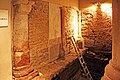
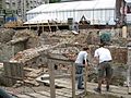
Excavations as part of the Regionale 2010
Start of excavations in January 2008, Portalsgasse
Environment of the mikveh, summer 2010

Parcels along the top of Mars gates

East side to Judengasse


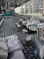
The currently ongoing excavations on the area of the Rathausplatz to the south of today's Portalsgasse are based on plans that were already discussed in the 1950s during Doppelfeld's time in office. Doppelfeld, who had also uncovered the Roman praetorium on the town hall grounds (Spanish building) , suggested expanding the underground facility created for the public and presenting future archaeological monuments there.

In 1969, however, only a partial excavation followed south of the town hall arbor, which was presented but not further developed. Only the approved project of the Regionale 2010 of the Cologne / Bonn region , a foundation of the state of North Rhine-Westphalia , gave the city the opportunity to realize the old plans. The excavation work, which has now been going on for a number of years, is linked to the double fields and now covers the entire area of the square. They open up an area of almost 10,000 m² of floor space, which reveals the basic structures of Roman buildings and the medieval buildings (especially the Jewish quarter) in their preserved remains to the experts.
Publications during the excavations
Periods of time for which no supportive indications are available in the sources can now be clarified by modern methods. A luminescence dating for a water basin that Doppelfeld has probably already seen, which is far before the first entries in the shrine, could be made. In the case of the basin embedded in a screed , no absolute density was determined because no sealing mortar ( Opus signinum ) had been used in its joints to prevent the water from seeping away. Apparently there was no shortage of water in the quarter, so that a strong sintered layer formed through constant supply and overflow , the analysis of which showed an age of around one thousand years.
Under goldsmith
The old street name Unter Goldschmied could be clearly assigned to the goldsmith's trade, which is well represented there, thanks to abundant finds. Typical equipment of this guild was recovered, including tasting stones , crucibles , casting molds and small melting furnaces made of trachyte, which were used in workshops in the 13th century.
Above Mars gates
For the southern part of the site, the excavations along the Oben Marspforten street revealed a plot structure that, starting from the Roman era of the city until the Second World War , has remained unchanged since medieval times. The house on the south-west corner of the street, called “Zum Golde”, was owned by Maria Gultslegersa in 1300, who ran a gold leaf factory. In the 15th century, the property was divided into a large and a small “Zum Golde” house. So far, however, only the eastern parcel has been examined, as the rest is located below the Unter Goldschmied street, which is still open to flowing traffic. The identified parcels of the houses Nichols, Koppe, Bardewich and Nussia adjoin this house to the east of Judengasse. The house of Nichols (not yet fully investigated) was owned by goldsmiths from around 1150 to 1285 and then passed into Jewish ownership. The Koppe house, with a partially preserved vault made from tuff stone from the 12th century and pillar remains made from trachyte from the Drachenfels rock from the 14th century, is seen by the experts as an early Romanesque town house, which would have been comparable to the preserved Overstolzenhaus . The Bardewich house is said to have served the goldsmiths as a guild house before 1200. It was bought by Johannes de Bardewich, his namesake, around 1200 and was the district's department store or yarn store in the 14th and 15th centuries. This house also points to the origin of its construction, as its substructure stood on Roman tuff blocks that could be assigned to the 1st century.

Synagogue environment
When Doppelfeld's investigations were resumed, the subsequent excavations in the area of the synagogue resulted in an optimization of his findings at the time. The phase structure that he was able to undertake in relation to the recent history of the synagogue was no longer comprehensible because the leveling work there in the 1950s destroyed the area near the surface. The surrounding benches of the synagogue, the Torah shrine , which merged into the substructure of Stefan Lochner's altar of the town patron , as well as parts of the substructure of the Bimah and other findings were destroyed.
However, some of the material that Doppelfeld has already recovered has been reproduced in the current excavations. Such as the more than 160 fragments of the Bimah, which have now grown to over 350 as a result of further finds and can thus be reconstructed. Details about the interior of the synagogue have also become known. In addition to fragments of the glazing, colored glazed tiles of the floor, pieces of the whitewashed walls and cornices as well as parts of niches and door frames were hidden . Also essential fragments of the Torah shrine could be recovered, as well as the building sculptures assigned to the mikveh .
Apartment of a Jewish family
An abundance of material that belongs to the apartment on the upper floor of the synagogue was recovered from the cesspool under the synagogue. It was things of everyday life that give a comprehensive insight into the living conditions of a wealthy Jewish family in Cologne in the 14th century and are unique in this diversity. The following were recovered: book fittings, remains of parchment with Hebrew characters, children's toys, medicine bottles, metal fittings of the furniture, window glazing and parts of the roof covering. The sewer also provides information on kosher cooking. The abundance of animal bones and botanical remains that still existed in it enabled the experts to precisely date the material, which shows that the apartment above the synagogue was inhabited until August 1349.
Future design of the historical site

The process of expanding municipal administrative buildings, which began with the first expansion of the House of Citizens, continued for centuries. The historical buildings of the town hall and the tower, which were rebuilt after the war destruction , as well as the new south-eastern administration building now cover the area between Alter Markt, Marsplatz and Judengasse. The entire area between Portalsgasse, Unter Goldschmied, Kleine Budengasse and Bürgerstrasse is occupied by the council buildings of the Spanish building grouped around an inner courtyard. However, this post-war complex covers the subterranean system of the Praetorium , the former residence and official residence of the governor of the province “Germania Inferior” as well as his administrative buildings.
Underground exhibitions
This facility is to be joined by further underground exhibition areas in the future, with the current excavation area with a presentation area of approximately 7,000 m². Overall, the result will be a system that will be one of the largest of its kind in Europe.
The system under construction, the planning of which has been ongoing since 2009, should be completed in 2013 and then be made available to the public. The exhibition is to have its entrance at the lower Alter Markt and will be able to give visitors an insight into several epochs of Cologne's history in different exhibition areas . The tour should include the Roman praetorium, the vault of the Plasman cellar and the then covered current excavation area of the Rathausplatz with the remains of its buildings, which will be enriched in detail by exhibited finds and additional information (also virtual). The outstanding locations will include the old vault of the Koppe house, which was demolished around 1850 and replaced by a new building, whose Romanesque vault is to be restored. Another highlight of the underground facility will be a visit to the Jewish bath, the mikveh, which will no longer be accessible from the Rathausplatz.
Jewish Museum
This square was the open space that was created after the medieval expulsion of the Jews and has remained so far in the core of the former Jewish quarter. According to the planning and the tender competitions initiated by the city, the town hall square is to become the location of a Jewish museum.
Further information
Main article: Jewish history in Cologne
literature
- Hermann Keussen : Topography of the City of Cologne in the Middle Ages , in 2 volumes. Cologne 1910. ISBN 978-3-7700-7560-7 and ISBN 978-3-7700-7561-4 .
- Hans Vogts , Fritz Witte: The art monuments of the city of Cologne , on behalf of the provincial association of the Rhine province and the city of Cologne. Published by Paul Clemen , Vol. 7, Section IV: The profane monuments of the city of Cologne , Düsseldorf 1930. Verlag L. Schwann, Düsseldorf. Reprint Pedagogischer Verlag Schwann, 1980. ISBN 3-590-32102-4 .
- Werner Eck : Cologne in Roman times. History of a city as part of the Roman Empire (History of the City of Cologne Volume 1) . Greven, Cologne 2004, ISBN 3-7743-0357-6 .
- Thomas Otten , Hansgerd Hellenkemper , Jürgen Kunow , Michael Rind : Find stories - archeology in North Rhine-Westphalia. Accompanying book for the state exhibition NRW 2010. On behalf of the Ministry for Building and Transport of the State of North Rhine-Westphalia in cooperation with the Archäologische Gesellschaft Köln e. V., 2010, ISBN 978-3-8053-4236-0 (museum edition).
- Robert Hoeniger , Moritz Stern (ed.): The Judenschreinsbuch der Laurenzpfarre zu Cologne. Publishing house Simion, Berlin 1888.
- Adolf Kober : land register of the Cologne Jewish quarter 1135-1425 . A contribution to the medieval topography, legal history and statistics of the city of Cologne. Bonn 1920 (= publications of the Society for Rhenish History 34).
- Carl Dietmar: "Die Chronik Kölns", Chronik Verlag, Dortmund 1991. ISBN 3-611-00193-7 .
- Adam Wrede : New Cologne vocabulary . 3 volumes A - Z, Greven Verlag, Cologne, 9th edition 1984, ISBN 3-7743-0155-7 .
- Klaus Dresmann: Constitution and proceedings of the Cologne council courts . Dissertation in the Law Faculty of the University of Cologne, 1959.
- Christoph Bellot, in: Walter Geis, Ulrich Krings (Hrsg.): The Gothic town hall and its historical surroundings (= Stadtspuren. Monuments in Cologne, Vol. 26), Cologne: JP Bachem Verlag 2000, ISBN 3-7616-1391-1 .
- Ed. LVR-Jewish Museum in the Archaeological Quarter of Cologne: The decree of 321: Cologne, the emperor and the Jewish history. undated, ISBN 978-3-96719-002-1 .
Individual evidence
- ↑ a b c d e f g h i j k l Hermann Keussen: The Jewish Quarter with a Map, in: Topography of the City of Cologne in the Middle Ages , Volume I., p. 30 ff and the St. Laurenz Shrine District, map u. Street register, p. 183 ff
- ↑ a b Vogts, Witte: Die Kunstdenkmäler der Stadt Köln , on behalf of the Provincial Association of the Rhine Province and the City of Cologne. Edited by Paul Clemen , vol. 7, section IV: The profane monuments of the city of Cologne , p. 263 ff
- ↑ Werner Eck, Volume 1, 2004. P. 325.
- ↑ Keussen, Volume IS 31, note 1). with reference to Julius Aronius : Regesta on the history of the Jews in the Frankish and German empires up to the year 1273. Edited by Julius Aronius with the assistance of Albert Dresdner and Ludwig Lewinski. Simion, Berlin 1902, No. 2.
- ^ A b c d e f g h i Sven Schütte : The Archaeological Zone Cologne , p. 241 ff, in: Thomas Otten , Hansgerd Hellenkemper, Jürgen Kunow, Michael Rind: Fundgeschichten - Archeology in North Rhine-Westphalia. Accompanying book for the state exhibition NRW 2010
- ↑ Keussen, Volume IS 31, note 1). with reference to Julius Aronius: Regesta on the history of the Jews in the Frankish and German empires up to the year 1273. Edited by Julius Aronius with the assistance of Albert Dresdner and Ludwig Lewinski. Simion, Berlin 1902, No. 2., and p. 33.
- ↑ Klaus Dresmann, page 3, reference to Ratjen FA, constitution and seat of the courts in Cologne in the overall picture of the city, p. 23 ff
- ^ Adam Wrede, Volume I, p. 301 b
- ^ Hermann Keussen, Topography of the City of Cologne in the Middle Ages , Vol. IS 143.
- ^ Adam Wrede, Volume I, p. 393.
- ^ Hermann Keussen, Topography of the City of Cologne in the Middle Ages , Volume I, page 210, column af, St. Laurenz district. With reference to: Hoeniger, Schreinsurkunden I 235, and Lau, Cologne 17. IV 1307. 38.60, and Lau, Cologne 276; as well as Stein, files I 89 and Knipping, 1373 City Accounts II, 112 (domini nostri excuntes ad Stessam)
- ↑ Hermann Keussen: The Jewish Quarter with a Map, in: Topography of the City of Cologne in the Middle Ages , Volume I., p. 196, Col. a and b, with reference to (document n. 25 a) and Lacomblet, document book I. 461 Joh. Ecclesiasticus s. Laurentii
- ^ Hermann Keussen, Volume I., St. Brigida District, p. 94. Sp. B
- ↑ Hermann Keussen, with reference to: 1341 Stein, Akten I, 45
- ↑ Hermann Keussen, Volume I, map of the Jewish quarter until 1349
- ^ A b Carl Dietmar: "The Chronicle of Cologne", p. 111.
- ^ Robert Hoeniger , with reference to Hebrew documents no.77
- ↑ Hoeniger, with reference to Hebrew Documents No. 87
- ↑ Hoeniger, with reference to Hebrew documents no.181
- ↑ Hoeniger, pp. 172–179
- ↑ Robert Hoeniger , Moritz Stern (ed.): The Judenschreinsbuch der Laurenzpfarre zu Köln
- ↑ Adolf Kober: The land register of the Cologne Jewish quarter 1235-1425
- ↑ the name exists in different spellings
- ↑ Carl Dietmar: "The Chronicle of Cologne", p. 114.
- ^ Hermann Keussen, S. Brigiden District, Volume I., p. 126 b
- ^ Keussen: Topography of the City of Cologne in the Middle Ages , Bd. IS 154, map of the St. Laurenz district
- ↑ Keussen: Topography of the City of Cologne in the Middle Ages , Bd. IS 171, 175 f
- ↑ Paul Clemen Vol. 7, p. 263, Section IV: The profane monuments of the city of Cologne , with reference to Kober in: Germania Judaica I, 1907, p. 71 and 80.
- ↑ Hermann Keussen, Directory of Hospitals, Poor and Pilgrim Hostels, Volume I, p. 155.
- ^ Info from the city of Cologne
- ^ Municipal information in the exhibition of the mikveh
- ↑ a b c Vogts, Witte: The art monuments of the city of Cologne , on behalf of the provincial association of the Rhine province and the city of Cologne. Edited by Paul Clemen , vol. 7, section IV: The profane monuments of the city of Cologne , building history of the town hall p. 183 ff
- ↑ Christoph Bellot in: Walter Geis, Ulrich Krings (Hrsg.): The Gothic town hall and its historical surroundings ,> S. 278 to 282.
- ↑ Otto Doppelfeld: The excavations in Cologne's Jewish quarter. In: Zvi Asaria (ed.): The Jews in Cologne from the oldest times to the present. Cologne 1959, p. 88.
- ↑ Information on the display boards on the excavation site
Coordinates: 50 ° 56 '17.4 " N , 6 ° 57' 28" E