Canton of Chalabre
| Former Canton of Chalabre |
|
|---|---|
| region | Languedoc-Roussillon |
| Department | Aude |
| Arrondissement | Limoux |
| main place | Chalabre |
| Dissolution date | March 29, 2015 |
| Residents | 3,389 (Jan 1, 2012) |
| Population density | 17 inhabitants / km² |
| surface | 201.98 km² |
| Communities | 15th |
| INSEE code | 1111 |
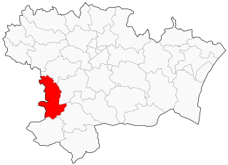
 Location of the canton of Chalabre in the Aude department |
|
The canton of Chalabre was a French constituency in the Aude department and in the Languedoc-Roussillon region until 2015 . It comprised 15 parishes in the Arrondissement of Limoux ; its main town (French: chef-lieu ) was Chalabre . The nationwide changes in the composition of the cantons resulted in its dissolution in March 2015.
The canton was 201.98 km² and last had 3257 inhabitants (as of 2012), which corresponded to a population density of 15 inhabitants per km². It was on average at 417 m , between 314 m in Caudeval and 1090 m in Rivel.
Communities
The canton consisted of 15 municipalities:
| local community | Population (as of 2017) |
Code postal | Code Insee |
|---|---|---|---|
| Caudeval | 185 | 11230 | 11080 |
| Chalabre | 1118 | 11230 | 11091 |
| Corbières | 27 | 11230 | 11100 |
| Courtauly | 73 | 11230 | 11107 |
| Gueytes-et-Labastide | 44 | 11230 | 11171 |
| Montjardin | 87 | 11230 | 11249 |
| Peyrefitte-du-Razès | 48 | 11230 | 11282 |
| Puivert | 471 | 11230 | 11303 |
| Rivel | 199 | 11230 | 11316 |
| Saint-Benoît | 105 | 11230 | 11333 |
| Sainte-Colombe-sur-l'Hers | 435 | 11230 | 11336 |
| Saint-Jean-de-Paracol | 124 | 11260 | 11346 |
| Sonnac-sur-l'Hers | 135 | 11230 | 11380 |
| Tréziers | 100 | 11230 | 11400 |
| Villefort | 89 | 11230 | 11424 |
Population development
| 1962 | 1968 | 1975 | 1982 | 1990 | 1999 | 2006 | 2012 |
|---|---|---|---|---|---|---|---|
| 4001 | 4374 | 3770 | 3642 | 3352 | 3257 | 3398 | 3389 |