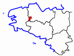
Canton of Maël-Carhaix
| Former canton of Maël-Carhaix |
|
|---|---|
| region | Brittany |
| Department | Cotes-d'Armor |
| Arrondissement | Guingamp |
| main place | Maël-Carhaix |
| Dissolution date | March 29, 2015 |
| Residents | 5,651 (Jan 1, 2012) |
| Population density | 30 inhabitants / km² |
| surface | 186 km² |
| Communities | 8th |
| INSEE code | 2223 |
The canton of Maël-Carhaix was until 2015 a French canton in the arrondissement of Guingamp , in the department of Côtes-d'Armor and in the region of Brittany ; its main town was Maël-Carhaix .
location
Communities
The canton of Maël-Carhaix comprised eight municipalities:
| local community | Breton | Population (2017) |
Area (km²) |
Code postal | Code Insee |
|---|---|---|---|---|---|
| Locarn | Lokarn | 407 | 32.36 | 22340 | 22128 |
| Maël-Carhaix | Mêl Karaez | 1,499 | 36.57 | 22340 | 22137 |
| Le Moustoir | Ar Vouster | 666 | 14.85 | 22340 | 22157 |
| Paule | Paoul | 707 | 37.56 | 22340 | 22163 |
| Plévin | Plevin | 751 | 27.36 | 22340 | 22202 |
| Trébrivan | Trabrivan | 741 | 22.96 | 22340 | 22344 |
| Treffrin | Trefrin | 548 | 7.47 | 22340 | 22351 |
| Tréogan | Treogan | 100 | 7.10 | 22340 | 22373 |
| Canton | Mêl Karaez | 5,651 | 186.23 | - | 2223 |
Population development
| 1962 | 1968 | 1975 | 1982 | 1990 | 1999 | 2006 | 2012 |
|---|---|---|---|---|---|---|---|
| 7,361 | 6,648 | 5,969 | 5,668 | 5,492 | 5,359 | 5,484 | 5,651 |
