Maël-Carhaix
|
Maël-Carhaix Mêl-Karaez |
||
|---|---|---|

|
|
|
| region | Brittany | |
| Department | Cotes-d'Armor | |
| Arrondissement | Guingamp | |
| Canton | Rust races | |
| Community association | Kreiz-Breizh | |
| Coordinates | 48 ° 17 ′ N , 3 ° 25 ′ W | |
| height | 114-243 m | |
| surface | 36.57 km 2 | |
| Residents | 1,499 (January 1, 2017) | |
| Population density | 41 inhabitants / km 2 | |
| Post Code | 22340 | |
| INSEE code | 22137 | |
Maël-Carhaix ( Breton : Mêl-Karaez ) is a French commune with 1,499 inhabitants (as of January 1, 2017) in the Côtes-d'Armor department in Brittany . It belongs to the arrondissement of Guingamp , to the canton of Rostrenen (until 2015: canton of Maël-Carhaix ) and is a member of the local authority association Kreiz-Breizh . The inhabitants are called Maël-Carhaisiens .
geography
Maël-Carhaix is about 50 kilometers northeast of Quimper . Maël-Carhaix is surrounded by the neighboring communities of Locarn in the north, Kergrist-Moëlou in the east, Glomel in the south and south-east, Paule in the south and south-west, Le Moustoir in the west and south-west, and Trébrivan in the west and north-west.
Population development
| year | 1962 | 1968 | 1975 | 1982 | 1990 | 1999 | 2006 | 2013 |
| Residents | 2.173 | 2,046 | 1,832 | 1,663 | 1,613 | 1,538 | 1,512 | 1,574 |
| Source: Cassini and INSEE | ||||||||
Attractions
See also: List of Monuments historiques in Maël-Carhaix
- Parts of a Roman aqueduct
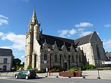
- Saint-Pierre church, built at the end of the 14th century
- Maël-Carhaix manor house
Personalities
- Glenmor , real name Émile Le Scanff (1931–1996), singer
literature
- Le Patrimoine des Communes des Côtes-d'Armor. Flohic Editions, Volume 2, Paris 1998, ISBN 2-84234-017-5 , pp. 654-655.

