
Carnoët
|
Carnoët Karnoed |
||
|---|---|---|
.svg)
|
|
|
| region | Brittany | |
| Department | Cotes-d'Armor | |
| Arrondissement | Guingamp | |
| Canton | Callac | |
| Community association | Guingamp Paimpol Armor Argoat Agglomération | |
| Coordinates | 48 ° 22 ′ N , 3 ° 31 ′ W | |
| height | 87-235 m | |
| surface | 42.06 km 2 | |
| Residents | 661 (January 1, 2017) | |
| Population density | 16 inhabitants / km 2 | |
| Post Code | 22160 | |
| INSEE code | 22031 | |

Carnoët ( Breton Karnoed ) is a French municipality with 661 inhabitants (as of January 1 2017) in the department of Côtes-d'Armor in the region of Brittany . It belongs to the arrondissement of Guingamp and the canton of Callac . The inhabitants are called Carnoëtois (es) .
geography
Carnoët is about 57 kilometers west-southwest of Saint-Brieuc .
Population development
| year | 1793 | 1821 | 1831 | 1851 | 1911 | 1936 | 1962 | 1968 | 1975 | 1982 | 1990 | 1999 | 2006 | 2012 |
| Residents | 1,433 | 1,471 | 1,841 | 2,169 | 2,538 | 1.939 | 1,489 | 1,350 | 1,061 | 840 | 727 | 729 | 751 | 723 |
| Sources: Cassini and INSEE | ||||||||||||||

Carnoët train station

Carnoët village church

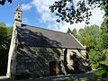
Saint-Gildas Chapel
Notre-Dame du Pénity chapel


Architectural monuments
See: List of Monuments historiques in Carnoët
literature
- Le Patrimoine des Communes des Côtes-d'Armor. Flohic Editions, Volume 1, Paris 1998, ISBN 2-84234-017-5 , pp. 112-113.
Web links
Commons : Carnoët - collection of images, videos and audio files