
Lanrivain
|
Lanrivain Larruen |
||
|---|---|---|
|
||
| region | Brittany | |
| Department | Cotes-d'Armor | |
| Arrondissement | Guingamp | |
| Canton | Rust races | |
| Community association | Kreiz-Breizh | |
| Coordinates | 48 ° 21 ′ N , 3 ° 13 ′ W | |
| height | 160-281 m | |
| surface | 36.74 km 2 | |
| Residents | 456 (January 1, 2017) | |
| Population density | 12 inhabitants / km 2 | |
| Post Code | 22480 | |
| INSEE code | 22115 | |

Lanrivain ( Breton : Larruen ) is a French commune with 456 inhabitants (as of January 1, 2017) in the Côtes-d'Armor department in Brittany . It belongs to the arrondissement of Guingamp , to the canton of Rostrenen (until 2015: canton of Saint-Nicolas-du-Pélem ) and is a member of the local authority association Kreiz-Breizh . The inhabitants are called Lanrivanais .
geography
Lanrivain is about 15 miles south of Guingamp . The Blavet limits the community to the west. Lanrivain is surrounded by the neighboring communities of Kerien in the north, Magoar in the north and northeast, Kerpert in the northeast, Saint-Nicolas-du-Pélem in the east and southeast, Plounévez-Quintin in the south, Trémargat in the west and southwest and Peumerit-Quintin in the west and Northwest.
Population development
| year | 1962 | 1968 | 1975 | 1982 | 1990 | 1999 | 2006 | 2012 |
| Residents | 960 | 882 | 761 | 638 | 510 | 524 | 554 | 538 |
| Source: Cassini and INSEE | ||||||||
Attractions
See also: List of Monuments historiques in Lanrivain
- Saint-Grégoire church, a historic monument since 1931
- Saint-Antoine Chapel, Monument historique
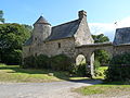
- Chapel of Lannégant, Monument historique
- Gollodic mansion, Monument historique
- Calvaire, Monument historique
- 18th century cross, Monument historique

Saint-Grégoire church

Saint-Antoine chapel

Chapel of Lannégant
Gollodic mansion


Community partnerships
A partnership with the Irish community of Ballymakeera in County Cork has existed since 2005.
literature
- Le Patrimoine des Communes des Côtes-d'Armor. Flohic Editions, Volume 2, Paris 1998, ISBN 2-84234-017-5 , pp. 1250-1253.